Calhoun, Kentucky facts for kids
Quick facts for kids
Calhoun, Kentucky
|
|
|---|---|

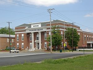
McLean County Courthouse in Calhoun
|
|

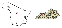
Location in McLean County, Kentucky
|
|
| Country | United States |
| State | Kentucky |
| County | McLean |
| Area | |
| • Total | 0.67 sq mi (1.73 km2) |
| • Land | 0.65 sq mi (1.69 km2) |
| • Water | 0.02 sq mi (0.04 km2) |
| Elevation | 394 ft (120 m) |
| Population
(2020)
|
|
| • Total | 725 |
| • Density | 1,108.56/sq mi (427.99/km2) |
| Time zone | UTC-6 (Central (CST)) |
| • Summer (DST) | UTC-5 (CDT) |
| ZIP code |
42327
|
| Area code(s) | 270 & 364 |
| FIPS code | 21-11854 |
| GNIS feature ID | 0488604 |
Calhoun is a small city in McLean County, Kentucky, United States. It's known as a "home rule-class city," which means it has its own local government. In 2020, about 725 people lived here. Calhoun is also the main town, or county seat, of McLean County. It is part of the larger Owensboro, Kentucky area.
Contents
History of Calhoun
How Calhoun Got Its Name
The area where Calhoun is today was first called "Rhoadsville." It was named after Captain Henry Rhoads, who planned the town between 1784 and 1785. This was near a part of the Green River where the water flowed quickly. Captain Rhoads' brother, Solomon, even built a fort to keep the early settlers safe.
Later, around 1787, a man named John Hanley took over Rhoads' land. The town's name changed then, and it was sometimes called "Fort Vienna" or "Vienna Station."
In 1849, a post office opened here. It was named "Calhoon" after a Kentucky politician, John Calhoon. The state government officially recognized the town in 1852 with this new name. Over time, the spelling changed to "Calhoun." This might have happened because people confused it with a more famous politician, John C. Calhoun, who was a Vice President from South Carolina.
In 1854, Calhoun was chosen to be the county seat for the new McLean County. It was picked over a nearby town called Rumsey, Kentucky, which is on the other side of the river.
Geography of Calhoun
Where is Calhoun Located?
Calhoun is in the middle of McLean County. It sits on the north side of the Green River. This river is the longest one that stays entirely within Kentucky. There's a special structure called Lock and Dam #2 on the river right at Calhoun. This helps boats travel along the river. Just across the river to the south is the community of Rumsey.
Roads and Travel
Several roads pass through Calhoun. Kentucky Route 81 goes through the town as its Main Street. If you go north on this road, you'll reach Owensboro in about 21 miles. Going south for about 23 miles will take you to Central City.
Kentucky Route 256 starts in the center of Calhoun as 1st Street. It goes northwest for about 10 miles to Beech Grove. Kentucky Route 136 crosses the northern part of Calhoun. It also goes to Beech Grove in the northwest and to Livermore in the southeast, about 10 miles away.
Size of the City
The United States Census Bureau says that Calhoun covers about 0.67 square miles (1.73 square kilometers). Most of this area is land, with only a small part, about 0.02 square miles (0.04 square kilometers), being water.
Climate
Calhoun has a climate with hot, humid summers. The winters are usually mild to cool. This type of weather is called a humid subtropical climate.
Population Information
| Historical population | |||
|---|---|---|---|
| Census | Pop. | %± | |
| 1860 | 511 | — | |
| 1880 | 373 | — | |
| 1890 | 637 | 70.8% | |
| 1900 | 631 | −0.9% | |
| 1910 | 742 | 17.6% | |
| 1920 | 743 | 0.1% | |
| 1930 | 683 | −8.1% | |
| 1940 | 753 | 10.2% | |
| 1950 | 746 | −0.9% | |
| 1960 | 817 | 9.5% | |
| 1970 | 901 | 10.3% | |
| 1980 | 1,080 | 19.9% | |
| 1990 | 854 | −20.9% | |
| 2000 | 836 | −2.1% | |
| 2010 | 763 | −8.7% | |
| 2020 | 725 | −5.0% | |
| U.S. Decennial Census | |||
Calhoun's Population in 2010
The 2010 census showed that 763 people lived in Calhoun. These people lived in 317 different homes, and 184 of these were families. About 74 families had children under 18 years old living with them.
On average, there were about 2.15 people in each home and 2.85 people in each family. In 122 homes, only one person lived there.
Most of the people in Calhoun were white (754 out of 763). There were also four people who identified as Native American and five people who were of more than one race. A small number of white people (two individuals) said they were Hispanic or Latino, with roots in Mexico.
The average age of people in Calhoun was 46.4 years old. Women tended to be a bit older on average (49.3 years) than men (44.2 years). This means women in Calhoun generally live longer. For example, among people aged 85 and older, there were 38 women and 19 men.
Notable people
- Glover H. Cary (1885–1936), a congressman who represented Kentucky.
See also
 In Spanish: Calhoun (Kentucky) para niños

