
California Historical Landmarks in Sacramento County facts for kids
This list shares some of the most important and interesting places in Sacramento County, California that have been named California Historical Landmarks. These landmarks are special spots that help us remember important events, people, and buildings from the past. They tell the story of how California grew and changed over time.
Contents
Exploring Sacramento County's Historic Landmarks
Sacramento County is full of history, and many places here are recognized as California Historical Landmarks. These special sites help us learn about the past, from early settlements to important buildings and key moments in transportation.
Famous Buildings and Sites
Many buildings in Sacramento County have played a big part in California's history.
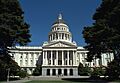
The California State Capitol
The California State Capitol in Sacramento is where California's government works. It's a beautiful building where laws are made and important decisions happen for the state.

Old Sacramento's Treasures
Old Sacramento State Historic Park is a historic area along the Sacramento River. Many buildings here are landmarks because they show what the city was like during the Gold Rush.
- The Adams and Company Building (1014 2nd St.) was once a busy business hub.
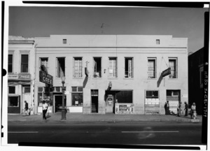
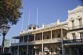
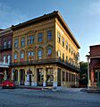
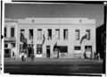
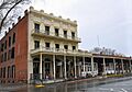
- The B.F. Hastings Building (1000 2nd St.) was home to a bank and a key stop for the Pony Express.

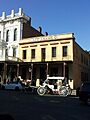
- The Booth Company building (1015-17 Front St.) is another example of the old businesses that thrived here.

- The D.O. Mills Bank Building (2nd and J Sts.) was an important bank in early Sacramento.
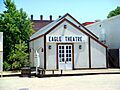
- The Eagle Theatre (925 Front St.) was California's first permanent theater building. Imagine watching a show here long ago!

- Ebner's Hotel (116 1/2 K St.) was a popular place for travelers to stay.

- The Lady Adams Building (117-19 K St.) is one of the oldest buildings in Old Sacramento.

- The Orleans Hotel (1018 2nd St.) and the Overton Building (2nd and J Sts.) are also part of Old Sacramento's rich history.
- The Pioneer Telegraph Station (1015-2nd St.) was where the first telegraph messages were sent in California. This was a huge step for communication!
- The Original Sacramento Bee building (Under N-bound offramp of I-5, W side of 3rd St between J and K Sts) was the first home of a major newspaper.
- The Pioneer Mutual Volunteer Firehouse (200 ft NE of intersection of 3rd and J Sts) reminds us of early firefighting efforts.
- The Sam Brannan House (112 J. St.) belonged to a very important person in early California.
_Wiki.jpg)
- The Western Hotel (Parking lot, 200 ft NE of intersection of 2nd and K Sts.) and the What Cheer House (Front and K Sts.) were also important places for visitors and residents.
Other Significant Buildings
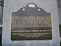
- The African Methodist Episcopal Church (715 Seventh St.) is a landmark because of its importance to the African American community in Sacramento.

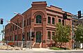
- The E.B. Crocker Art Gallery (216 O St.) is one of the oldest art museums in the Western United States.

- The First Jewish Synagogue (7th St between Capitol and L) was the first synagogue owned by a Jewish congregation on the West Coast.

- The Governor's Mansion (Governor's Mansion State Historic Park) was once home to many California governors.

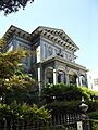
- The Leland Stanford Mansion (800 N St.) was the home of Leland Stanford, a former governor and founder of Stanford University.

- The Old Folsom Powerhouse Station (NE corner of 6th and H Sts) was part of an early system that brought electricity to Sacramento.

- The Pioneer Congregational United Church of Christ (915 6th St.) is a historic church building.
Transportation History
Sacramento County played a huge role in the history of transportation in California and the United States.
California’s First Passenger Railroad
The site of California’s First Passenger Railroad (3rd and R Sts.) marks where the first train in California carried passengers. This was a major step for travel and trade!
The Pony Express
The Pony Express was a famous mail service that used horseback riders to deliver letters across the country very quickly. Several stops were in Sacramento County:
- The Fifteen Mile House (White Rock & Gold Valley Rds.) near Rancho Cordova.
- The Five Mile House (California State University, 6000 "J" St.) in Sacramento.
- Folsom (819 Sutter St.) was also a key stop on the Pony Express route.
The First Transcontinental Railroad
The First Transcontinental Railroad (at Old Sacramento State Historic Park, California State Railroad Museum) began right here in Sacramento. This railroad connected the East and West Coasts of the United States, changing travel and trade forever.
Important People and Places
Many other sites honor important people or unique parts of Sacramento County's past.
Cemeteries and Burial Sites
- The Chevra Kaddisha Cemetery (3230 J St.) is a historic Jewish cemetery.
- The Grave of Alexander Hamilton Willard (Franklin Cemetery) belongs to a member of the famous Lewis and Clark Expedition.
- The Grave of Elitha Cumi Donner Wilder (Elk Grove Masonic Cemetery) is where a survivor of the Donner Party is buried.
- The New Helvetia Cemetery (Alhambra Blvd. and J St.) is another historic burial ground.
- The Sacramento Historic City Cemetery (Broadway and 10th Sts.) is a beautiful and historic cemetery.

Early Settlements and Mills
- Camp Union, Sutterville (Sutterville and Land Park Dr.) was a military camp during the Civil War.
- China Slough (near Sacramento Valley Station) was once a significant area for Sacramento's Chinese community.
- Coloma Road has two landmark locations: one near Nimbus Dam in Granite Bay and another near Sutter's Fort (28th and L Sts.) in Sacramento. This road was important during the Gold Rush.
- The Elk Grove Free Library (9125 Elk Grove Blvd.) was an early library in Elk Grove.
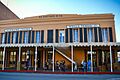
- The Folsom Terminal (Leidesdorff Plaza) was an important train station in Folsom.

- The Folsom Powerhouse (at Folsom Powerhouse State Historic Park) was one of the first hydroelectric power plants in the world.

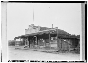
- Michigan Bar (State Hwy 16.) near Rancho Murieta was a mining town during the Gold Rush.
- Murphy's Corral (Grant Line Rd and Hwy 99) in Elk Grove was also known as Murphy's Ranch.
- Prairie City (Prairie City Rd, 500 ft N of State Hwy 50) near Folsom was another important Gold Rush town.
- The Sacramento Assembly Center aka Camp Kohler (Walerga Park) was a site used during World War II.
- The Sheldon Grist Mill (Meiss Rd and Hwy 16) near Sloughhouse was a mill that processed grain.
- Sloughhouse (Meiss St & Hwy 16.) was an early settlement and stagecoach stop.
- The State Indian Museum (2618 K St.) helps us learn about the history and culture of California's Native American people.
- Sutterville (Sutterville Rd, vicinity of Land Park Dr.) was an early settlement attempt near Sacramento.
- Sutter's Landing (28th and C Sts.) was a key spot on the Sacramento River.
Images for kids
-
African Methodist Episcopal Church
-
B.F. Hastings Building
-
Booth Company
-
California State Capitol
-
E.B. Crocker Art Gallery
-
Eagle Theatre
-
First and second state capitols
-
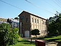
Ebner's Hotel
-
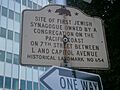
First Jewish Synagogue
-
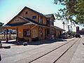
Folsom Terminal
-
Folsom Powerhouse
-
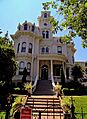
Governor's Mansion
-
Lady Adams Building
-
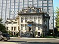
Leland Stanford Mansion
-

Michigan Bar
-
Old Folsom Powerhouse Station
-
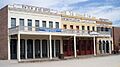
Old Sacramento
-
Original Sacramento Bee building
-
Sacramento Historic City Cemetery
-
Sam Brannan House


