Callejones facts for kids
Quick facts for kids
Callejones
|
|
|---|---|
|
Barrio
|
|

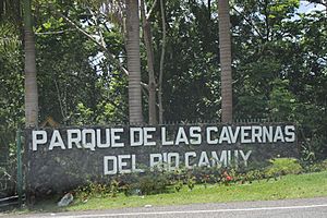
An entrance to the Camuy River Cave Park in Callejones
|
|

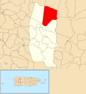
Location of Callejones barrio within the municipality of Lares shown in red
|
|
| Commonwealth | |
| Municipality | |
| Area | |
| • Total | 8.39 sq mi (21.7 km2) |
| • Land | 8.39 sq mi (21.7 km2) |
| • Water | 0 sq mi (0 km2) |
| Elevation | 1,207 ft (368 m) |
| Population
(2010)
|
|
| • Total | 4,575 |
| • Density | 545.3/sq mi (210.5/km2) |
| Source: 2010 Census | |
| Time zone | UTC−4 (AST) |
Callejones is a special area called a barrio in the town of Lares, Puerto Rico. In 2010, about 4,575 people lived there. Callejones is known for its cool caves, like Machos Cave (which means Cueva Machos in Spanish) and Pajita Cave (Cueva Pajita).
Contents
History of Callejones
Puerto Rico used to belong to Spain. After the Spanish–American War, Spain gave Puerto Rico to the United States. This happened because of a peace agreement called the Treaty of Paris of 1898. Puerto Rico then became a territory of the United States.
In 1899, the United States government counted all the people living in Puerto Rico. This count is called a census. The census found that 2,152 people lived in Callejones barrio at that time. The population has grown quite a bit since then!
| Historical population | |||
|---|---|---|---|
| Census | Pop. | %± | |
| 1900 | 2,152 | — | |
| 1980 | 2,765 | — | |
| 1990 | 3,584 | 29.6% | |
| 2000 | 4,361 | 21.7% | |
| 2010 | 4,575 | 4.9% | |
| U.S. Decennial Census 1899 (shown as 1900) 1910-1930 1930-1950 1980-2000 2010 |
|||
What are Sectors?
Barrios like Callejones are often divided into smaller areas. These smaller areas are called sectores (which means sectors in English). Think of them like neighborhoods within a bigger area.
Sectors can have different names, such as urbanización (a planned neighborhood), reparto (a land division), barriada (a settlement), or residencial (a housing complex).
Sectors in Callejones
Here are some of the sectors you can find in Callejones barrio:
- Arco Iris
- Berrocal
- Camino Emau
- Camino Julito Nieves
- Carmelo Mercado
- Copa de Oro
- Demetrio Otaño
- El Maná
- Las Lajas
- Los Adames
- Los Chayotes
- Los Luciano
- Los Otaño
- Miro Torres
- Monchín Rivera
- Sector Crematorio
- Sector Cueva Pajita
- Sector El 21
- Sector El Taino
- Sector Gregorio Rivera
- Sector La Gallera
- Sector La Pista
- Sector La Sierra
- Sector Las Campanas
- Sector León Vega
- Sector Los Nieves
- Sector Los Santiago
- Sector Pagán
- Sector Pedro Colón
- Sector Zenón Rivera
- Sico Torres
- Tramo Carretera 129
- Tramo Carretera 134
- Tramo Carretera 454
Ancient Archeological Site
Callejones is home to an interesting archeological site. An archeological site is a place where scientists study old human history. This site has a batey. A batey was a large, open area where ancient people held important ceremonies and played games.
This batey dates back to very old times, from about 600 AD to 1500 AD. Researchers like Jose Oliver from Yale University and Samuel Kirkland Lothrop have studied this special place to learn more about the people who lived there long ago.
See also
 In Spanish: Callejones (Lares) para niños
- List of communities in Puerto Rico
- List of barrios and sectors of Lares, Puerto Rico
Images for kids
 | Calvin Brent |
 | Walter T. Bailey |
 | Martha Cassell Thompson |
 | Alberta Jeannette Cassell |


