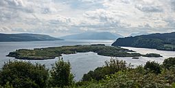
Calve Island facts for kids
 Calve Island viewed from Tobermory Golf Course |
|
| OS grid reference | NM521546 |
|---|---|
| Coordinates | 56°37′N 6°02′W / 56.62°N 6.04°W |
| Physical geography | |
| Island group | Mull |
| Area | 72 ha (180 acres) |
| Area rank | 171= |
| Highest elevation | 20 m (66 ft) |
| Administration | |
| Sovereign state | United Kingdom |
| Country | Scotland |
| Council area | Argyll and Bute |
| Demographics | |
| Population | 0 |
Calve Island is a small, flat island found off the east coast of the Isle of Mull in Argyll and Bute, on the west coast of Scotland. It is about 1.2 miles (1.9 km) long and 0.5 miles (0.8 km) wide.
Even though no one lives on Calve Island permanently, there is a farmhouse with other buildings on its western side. This house is used as a summer home. The Cotton family owns Calve Island and enjoys spending their summers there.
Contents
Tidal Islands Near Calve
Calve Island is considered a separate island from Mull. However, at very low tides, you can sometimes walk to it. This happens at its south-western point, across a small tidal island called Cnap a' Chailbhe. A tidal island is land that is connected to the mainland or another island only when the tide is out.
The water channel between Mull and Calve is called Dòirlinn a' Chailbhe. Calve Island helps protect Tobermory Bay from strong waves. This makes Tobermory Bay a safer place for boats to anchor. There is another small tidal island to the north-west of Calve called Eilean na Beithe.
Exploring Under the Sea
The waters around Calve Island are very popular for diving. Divers can explore rocky walls, reefs, and even old shipwrecks.
One amazing diving spot is a deep rock wall on the north-eastern side of the island. It goes down more than 44 metres (144 feet)! This spot was ranked as one of Scotland's best "Wall dives." It's known for its depth, the many sea creatures living there, and clear water.
Shipwrecks Around Calve
There are three known shipwrecks near Calve Island, all located between Calve and Mull.
The Pelican Wreck
The oldest and largest wreck is the Pelican. This was a steel paddle steamer built in 1850. It was first used as a passenger ferry. By 1895, it was used to store coal in Tobermory Harbour. In December 1895, a big storm caused the Pelican to break free from its moorings. It drifted across Tobermory Bay and hit rocks on Calve Island. When the tide went out, it slipped off the rocks and sank into 20 metres (66 feet) of water.
Other Shipwrecks
The Strathbeg is another wreck found at the south end of Dòirlinn a' Chailbhe. This motor fishing boat sank during a strong wind in May 1984 while it was anchored.
Divers have also found a third wreck, a single-masted smack called Anna Bhan. We don't know when or how this boat was lost.
Boat Accident in 2009
In May 2009, a speedboat called 'Sooty' crashed on the northern tip of Calve Island. The boat was traveling very fast when it hit the rocky shore. One person on board was thrown from the boat and sadly died from their injuries.
Calve Island's History
In 1934, two explorers, Alastair Dunnett and Seamus Adam, went on a kayak trip around the Inner Hebrides. They wrote reports about their journey for newspapers. They found that Calve Island was farmed by one large family. They even stayed to help with the harvest and met two sisters, Margaret and Janet McDonald, who were famous for their rowing skills.
Alastair Dunnett, who later became a famous newspaper editor, wrote that Calve was a rich land, even if it seemed a bit forgotten. In 2018, another historian, David Gange, visited Calve Island on a similar kayak trip. He noticed that unlike other Scottish islands that were growing, Calve still had no people living there and very little farming.
Calve Island Stamps
In 1984, special local stamps were made for Calve Island. These stamps had a picture of a Basset Hound dog on them. The closest official post office box is in Tobermory, on the main island of Mull.
 | Bessie Coleman |
 | Spann Watson |
 | Jill E. Brown |
 | Sherman W. White |

