
Cameron's 1 Ton Survey Post facts for kids
Quick facts for kids Cameron's 1 Ton Survey Post |
|
|---|---|
.jpg)
Cameron's 1 Ton Survey Post, 2007
|
|
| Location | Barwon River, Mungindi, Shire of Balonne, Queensland, Australia |
| Design period | 1870s - 1890s (late 19th century) |
| Built | 1882 |
| Official name: Cameron's 1 Ton Survey Post | |
| Type | state heritage (built) |
| Designated | 21 October 1992 |
| Reference no. | 600014 |
| Significant period | 1882 (fabric, historical)) |
| Lua error in Module:Location_map at line 420: attempt to index field 'wikibase' (a nil value). | |
Cameron's 1 Ton Survey Post is a special marker found on the bank of the Barwon River near Mungindi, Queensland, Australia. It's called "heritage-listed" because it's an important part of history. This large wooden post was put in place in 1882. It helps us remember the official survey that marked the border between Queensland and New South Wales.
Contents
History of the Border Post
This big wooden post, known as Cameron's 1 Ton Survey Post, was set up around 1882. It stands on the bank of the Barwon River. Its main job was to mark the official border between Queensland and New South Wales.
Why a Border Was Needed
For many years, people knew they needed a clear border. This was important for things like laws and trade between the two colonies. So, in mid-1879, surveyors from both colonies met. They started their work near a town called Barringun in New South Wales.
The Surveyors and Their Journey
The main surveyors were JB Cameron from New South Wales and GC Watson from Queensland. John Brewer Cameron was born in Scotland and came to Australia in 1853. He was known for being adventurous. He became a surveyor and was very good at it.
Their survey work began at a spot called Zero Obelisk in Barringun. Cameron's job was to figure out the exact location using stars. Watson was in charge of measuring distances.
They started surveying the border heading west. Their goal was to reach the border with South Australia. This spot is now known as Cameron Corner. It was a very long distance, about 378 kilometers (235 miles), across tough land.
Challenges Along the Way
The surveyors faced many problems. First, there were big floods in the Warrego and Paroo rivers. Then, a severe drought hit. They also had health issues and ran low on food and water. Watson eventually left the survey, but Cameron kept going. This part of the survey took over a year to finish!
In 1881, Cameron returned to Barringun. He then surveyed the eastern part of the border, heading towards the Barwon River. This section, about 320 kilometers (200 miles) long, was easier. There was plenty of water and grass.
The Famous One Ton Post
When the survey was finally done, Cameron wanted to mark the spot. He placed a huge wooden post on the river bank. This post weighed about one ton (1,000 kilograms) and had his name carved into it. That's how it got its name: Cameron's 1 Ton Survey Post. Even though other surveys had happened, this one was the official one.
John Cameron later moved to New Guinea for more important survey work. He passed away in 1897 in Brisbane. He is buried in the Toowong Cemetery.
What the Post Looks Like
Cameron's 1 Ton Survey Post is a tall wooden post. It stands about 2.7 meters (9 feet) high. It's shaped like a pyramid at the top. On one side, you can see "J. CAMERON GS" carved into the wood, going upwards. On another side, it says "LAT 29 ". This shows the latitude, or how far north or south the spot is.
Why This Post is Important
Cameron's 1 Ton Survey Post is listed on the Queensland Heritage Register. This means it's recognized as a very important historical site.
A Piece of Queensland's History
This post marks the first official survey of the border between Queensland and New South Wales. Back then, these were separate colonies. Knowing the exact border was very important for laws and trade. The post also reminds us of how difficult surveying was in the 1800s. Surveyors worked in incredibly tough conditions.
A Rare and Special Marker
Cameron's 1 Ton Survey Post is rare because it's one of the biggest wooden survey posts in Australia. It marks the end point of John Cameron's important survey at Latitude 29°.
Connected to a Key Person
This survey post is strongly linked to the life and work of John Brewer Cameron. His work helped shape Australia. The post is a lasting reminder of one of his greatest achievements.
Images for kids
-
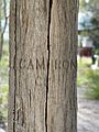
J. CAMERON GS carved on a post

