Cameron Corner Survey Marker facts for kids
Quick facts for kids Cameron Corner Survey Marker |
|
|---|---|

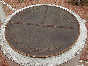
Cameron Corner Survey Marker, 2001
|
|
| Location | South-west Queensland, at the border corner with New South Wales and South Australia., Cameron Corner, Shire of Bulloo, Queensland, Australia |
| Design period | 1870s - 1890s (late 19th century) |
| Official name: Cameron Corner | |
| Type | state heritage (built) |
| Designated | 9 November 2012 |
| Reference no. | 602806 |
| Significant period | 1880- |
| Lua error in Module:Location_map at line 420: attempt to index field 'wikibase' (a nil value). | |
The Cameron Corner Survey Marker is a special historical landmark. It's located in Cameron Corner, Queensland, Australia. This marker shows where the borders of Queensland, New South Wales, and South Australia meet. It was put in place way back in 1880. This important spot is now protected on the Queensland Heritage Register.
Contents
History of the Border Marker
The Cameron Corner Survey Marker was set up in September 1880. This happened during the very first official survey of the western border. This survey was for the border between Queensland and New South Wales (NSW). It took place from 1879 to 1881. The marker shows the furthest western point of the Queensland-New South Wales border. Creating this marker was a huge achievement for surveyors at that time.
How Queensland's Borders Were Decided
After a lot of discussion, Queen Victoria officially created the new Colony of Queensland. This happened in June 1859. The Queen's special document, called "letters patent," described the border. It had three main parts:
- The first part followed the watershed from Point Danger west to the Dumaresq River. A watershed is like a natural dividing line.
- The second part followed rivers like the Dumaresq, Macintyre, and Barwon. This went up to a specific line of latitude, 29 degrees South.
- The third part followed that 29-degree South line all the way to the 141st line of East longitude. This 141st line was the eastern border of South Australia.
The parts of the border that followed rivers didn't need surveying. But the eastern and western sections did.
Surveying the Eastern Border
The eastern part of the border was surveyed between 1863 and 1866. Surveyors Francis Edward Roberts from Queensland and Isaiah Rowland from New South Wales worked on it. They started in June 1863. They had to survey the line from Point Danger west to the Dumaresq River.
They did two separate surveys. Sometimes they used the same tree to mark the border. But often, Roberts and Rowland marked the border in slightly different places. Queensland's chief surveyor, Roberts, changed his path a bit. He wanted to make the survey more accurate. In the end, both the New South Wales and Queensland governments mostly accepted Roberts' survey.
Marking the River Sections
The river section of the border was marked in 1865. This part followed the Dumaresq, Macintyre, and Barwon Rivers. It went up to the 29th parallel of South latitude. This was important for the governments. It helped them set fair rents for large farming areas. Some of these areas were in both colonies.
Augustus Charles Gregory, Queensland's Surveyor-General, helped with this survey. He worked with William Albert Baylesford Greaves from New South Wales. They marked the border with steel pins. These pins were driven a few inches underground. They also took measurements to nearby trees. This work was finished in about six weeks.
Settling the Western Lands
The western part of the border, at 29 degrees South, still needed to be surveyed. People started settling in south-west Queensland in the 1860s. By 1864, large cattle and sheep farms were being set up. The Bulloo Downs Station was one of the first in the Bulloo area. By the end of the 1860s, the Cooper Creek area was also settled.
By the 1870s, settlement spread even further west. This included areas near the Diamantina and Georgina. By 1885, almost all the land in Queensland's far south-west was claimed. This area is known as Channel Country. It has many rivers and creeks that flood. When it floods, it creates a network of channels. This makes the land great for raising cattle.
Border Taxes and Smuggling
Another reason for marking the border was to collect taxes. These were called customs duties. They were charged on goods moving between colonies. This started in the 1850s. It showed that the Australian colonies were growing apart. Each new colony set up its own Customs office. These offices collected taxes and tried to stop smuggling.
In 1862, Queensland agreed to a system with New South Wales. They would collect taxes on goods crossing their shared border. At first, not many goods moved through the inland areas. So, collecting taxes there wasn't worth the cost. But as more people settled, Queensland started losing money. They estimated they lost a lot each year. Many farms and shops in southern Queensland got their supplies from New South Wales. Taxes on things like tea and tobacco were twice as high in Queensland. This led to a lot of smuggling across the border.
By 1870, Queensland passed a new law. It allowed them to collect taxes on goods from other colonies. A small team of police was set up to patrol the border. They collected taxes and kept records. They also suggested places for new Customs offices. This increased effort meant more goods were sent to Brisbane instead of through the inland areas.
The Western Border Survey
Finally, in June 1879, the rest of the Queensland-NSW border was surveyed. This was the 29th parallel of south latitude. It stretched into the Channel Country. Survey teams from both colonies met at Barringun. William Jacomb Conder from NSW did some early work. He used stars to figure out the exact latitude of the border town.
Then, surveyors John Brewer Cameron from NSW and George Chale Watson from Queensland started the survey. They began on September 15, 1879. They started from a point on the Warrego River. They had put up a marker called the Zero Obelisk there. Watson was in charge of measuring distances. Cameron handled the astronomical measurements. These were needed for this precise survey.
Challenges of the Survey
The surveyors soon faced floods. Cameron wrote about how hard it was to cross creeks with their entire camp. He had to build two boats to ferry their supplies. After the floods, they faced the usual dry conditions of the south-west.
In March 1880, they reached the 100-mile mark on the Paroo River. Surveyor Watson then left the survey team. He felt Cameron was very precise and careful. Watson also had other duties as a land commissioner. This made it hard for him to fully participate in the survey.
So, Cameron was left to finish the survey alone. He had to survey the 29-degree South latitude across very remote and empty land. Cameron wrote about almost losing all their horses one night. They couldn't find water. He had to give the horses water mixed with oatmeal. This helped them travel to the next water source. He then had to let the horses rest for a week.
Cameron marked the corner where Queensland, NSW, and South Australia meet. He used a timber post with a special government arrow. The survey of 285 miles (459 km) from Barringun to the South Australian border took 12 months and 15 days.
After marking the corner, Cameron went back to Barringun. He then surveyed the eastern section of the border. This was about 200 miles (320 km) to the Barwon River. He finished the entire border survey in October 1881. Cameron also marked the end of the survey in the east. He used a one-ton post called Cameron's 1 Ton Survey Post.
About John Brewer Cameron
John Brewer Cameron was born in Scotland. He moved to Victoria, Australia, with his family in 1853. He worked in the Victorian goldfields and in New Zealand. He later returned to Victoria and joined a government surveying team. This led him to become a surveyor.
He worked in Fiji as a surveyor in 1869. He came back to Victoria in 1872. There, he became an expert in surveying and geodesy. By 1879, he was a top surveyor in New South Wales. He was also a member of the Royal Geographical Society of Australasia. He did the important survey of the Queensland-NSW border from 1879 to 1881.
In 1883, Cameron moved to New Guinea. He bought a farm there. He also guided Sir William MacGregor, the Government Resident, on exploration trips. In 1896, Cameron became the Government Surveyor of New Guinea. He sadly died suddenly from malaria in Brisbane on December 31, 1897. He was buried in Toowong cemetery. His former colleague, George Watson, said Cameron's border marks would be a lasting reminder of his skill.
The Corner Today
Cameron faced huge challenges during his survey. His work on the Queensland-NSW border was very impressive. Today, we have new technology like Global Positioning System (GPS). This allows us to find locations much more accurately.
It turns out the exact corner Cameron surveyed was slightly different from where it was supposed to be. The original corner post was replaced by a concrete pillar in 1969. Even today, official maps show slight differences. This shows how hard it was to survey remote areas back then.
The Queensland Boundaries Declaratory Act of 1982 confirmed the border. It said that the land boundaries, marked before 1900, are permanent. The corner post is also protected by law. People are not allowed to interfere with it.
Today, the Cameron Corner Survey Marker is a popular place for tourists to visit.
What Cameron Corner Looks Like
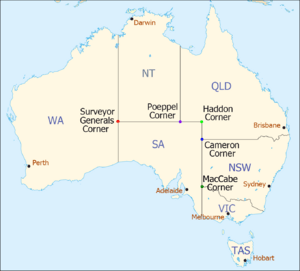
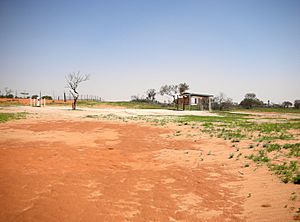
Cameron Corner Survey Marker is the southernmost of Queensland's three south-western corners. It is the westernmost point of the Queensland-New South Wales border. It is about 335 kilometres (208 mi) south of Haddon Corner. It is also about 450 kilometres (280 mi) south-east of Poeppel Corner. The area is very dry, with red dirt and sand. There is some native plant life.
The exact spot where 141 degrees East and 29 degrees South meet is about 112 metres (367 ft) to the south-east. This spot has no official marker.
Nearby, you can find:
- The Cameron Corner Store.
- A shelter shed with information boards on the NSW side.
- A road and road signs on the Queensland side.
- The famous Dingo Fence.
| Corners in Australia | |||||
|---|---|---|---|---|---|
| Name | Surveyor Generals | Poeppel | Haddon | Cameron | MacCabe |
| States | WA/NT/SA | NT/SA/Qld | SA/Qld | SA/Qld/NSW | SA/Vic/NSW |
Why Cameron Corner is Important
Cameron Corner Survey Marker was added to the Queensland Heritage Register on November 9, 2012. It met several important rules.
Shows Queensland's History The Cameron Corner Survey Marker was set up in 1880. It marks the western end of the first official Queensland-New South Wales border survey. It shows how important clear borders were to the governments. Having clear borders helped with economic growth and managing the colonies. It gave certainty to governments and farmers. It also helped them collect customs duties (taxes).
Cameron Corner is a result of early teamwork between the Australian colonies. It shows the amazing effort needed to finish the Queensland-New South Wales border survey.
Shows Great Technical Skill Cameron Corner shows a high level of technical skill for its time. It is the result of a very difficult surveying project. It was one of the first times such advanced surveying was used in Queensland.
Important to the Community Cameron Corner is important to the Australian community. It is a well-known geographical and cultural landmark. It is also a popular place for tourists to visit.
Connected to an Important Person Cameron Corner is strongly linked to the life and work of John Brewer Cameron (1843–97). It celebrates one of his most important achievements as a surveyor.
 | Victor J. Glover |
 | Yvonne Cagle |
 | Jeanette Epps |
 | Bernard A. Harris Jr. |


