Dumaresq River facts for kids
Quick facts for kids Dumaresq |
|
|---|---|

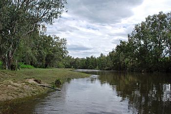
Dumaresq River near Texas, Queensland.
On the left bank is Queensland; on the right bank is New South Wales. |
|
|
Location of Dumaresq River mouth in New South Wales
|
|
| Native name | Karaula |
| Other name(s) | Macintyre Brook, Dumaresq or Severn River |
| Country | Australia |
| State | New South Wales, Queensland |
| Region | Northern Tablelands, Darling Downs, North West Slopes |
| Physical characteristics | |
| Main source | Great Dividing Range |
| River mouth | confluence with the Macintyre River east of Boggabilla, New South Wales 227 m (745 ft) 28°39′45″S 150°29′1″E / 28.66250°S 150.48361°E |
| Length | 214 km (133 mi) |
| Basin features | |
| River system | Macintyre River catchment, Murray–Darling basin |
| Tributaries |
|
The Dumaresq River is a long river in Australia. The local Indigenous Bigambul people call it Karaula. It's part of the Macintyre River system, which then flows into the even larger Murray–Darling basin. This river flows through parts of New South Wales and Queensland. It even forms part of the border between these two states!
Contents
River's Journey and Features
The Dumaresq River starts in the western mountains of the Great Dividing Range. It begins where two smaller rivers, the Queensland branch of the Severn River and Tenterfield Creek, join together. This meeting point is east of Glenlyon Dam in Queensland.
Where the River Flows
The river generally flows towards the southwest and then the northwest. Along its way, fourteen smaller rivers and creeks join it. These include the Mole River, Pike Creek, Beardy River, and Macintyre Brook. Finally, the Dumaresq River meets the Macintyre River east of Boggabilla. The river drops about 154 meters as it flows for 214 kilometers.
The Border Rivers Group
The Dumaresq River is part of a group of rivers called the Border Rivers. This group also includes Pike Creek, the Mole, Beardy, Severn (Queensland), Severn (New South Wales), and Macintyre rivers. The Dumaresq River flows past towns like Bonshaw in New South Wales, and Yelarbon and Texas in Queensland. South of Texas, the Bruxner Highway crosses over the river.
Life Along the River
The valley around the Dumaresq River is a busy place. You can find vineyards there, where grapes are grown. It's also a great spot for fishing. In the past, farmers in this valley grew tobacco crops. In 2011, a plant called water hyacinth was found in the river. This plant can cause problems for the river system.
River's Name and History
The traditional owners of the land around the Dumaresq River are the Indigenous Bigambul people. They have always called the river Karaula. The Kamilaroi people also have strong ties to this river.
How the River Got its Name
A European explorer and botanist named Allan Cunningham visited the river in 1827. He named it in honor of Lt-Colonel Henry Dumaresq. Henry Dumaresq was a relative of Ralph Darling, who was the Governor of New South Wales at that time. The Dumaresq River is very important for the people who live along its banks. It helps them with their daily lives and farming.
 | Selma Burke |
 | Pauline Powell Burns |
 | Frederick J. Brown |
 | Robert Blackburn |


