Haddon Corner facts for kids
Quick facts for kids Haddon Corner |
|
|---|---|
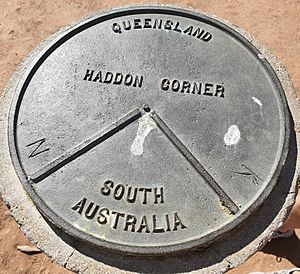
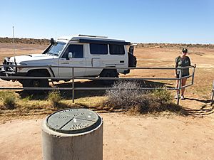
Survey mark at Haddon Corner, 2019
|
|
| Location | South-West Queensland, on the border corner with South Australia, Tanbar, Shire of Barcoo, Queensland, Australia |
| Design period | 1870s - 1890s (late 19th century) |
| Official name: Haddon Corner | |
| Type | state heritage |
| Designated | 9 November 2012 |
| Reference no. | 602807 |
| Lua error in Module:Location_map at line 420: attempt to index field 'wikibase' (a nil value). | |
Haddon Corner is a special historical place in Tanbar, Shire of Barcoo, Queensland, Australia. It is located in the outback Channel Country, right on the border between Queensland and South Australia. This important spot was added to the Queensland Heritage Register on 9 November 2012.
The corner was first measured by Augustus Poeppel in 1880. Haddon Corner sits exactly where the 26th parallel south (a line of latitude) crosses the 141st meridian east (a line of longitude).
History of Haddon Corner
First Peoples of the Land
The land around Haddon Corner is the traditional home of the Karuwali people. Their language, also known as Garuwali or Dieri, covers this part of far western Queensland. This includes areas within the Diamantina Shire Council, like Betoota and Haddon Corner.
Marking the Border
Haddon Corner was officially marked in 1880. This happened during a big survey of the western border between Queensland and South Australia. The survey took place between 1879 and 1880. Marking this spot was a huge achievement for surveyors back then. It shows the north-eastern point where Queensland and South Australia meet.
How Queensland's Borders Were Decided
In June 1859, Queen Victoria signed documents that created the new Colony of Queensland. This separated Queensland from New South Wales (NSW). The documents described Queensland's border using natural features like rivers and specific lines of latitude and longitude.
At first, the western border of Queensland was set at the 141st meridian. However, people soon wanted to change this. The Surveyor-General, Augustus Charles Gregory, thought the border should be moved further west. He believed this would give Queensland better access to important areas and harbours.
In 1861-1862, expeditions were sent to find explorers Burke and Wills. These journeys explored a huge part of inland Australia. This made people interested in the land beyond Queensland's western border. Queensland's Governor, George Bowen, wanted to protect any new settlers in this area. He suggested extending Queensland's western border to the 138th meridian.
This idea was accepted. So, on 12 April 1862, new documents were issued. They added land north of the 26th parallel and between the 141st and 138th meridians to Queensland. This created two more corners on Queensland's western boundary. It also gave the colony control over areas like the Barkly Tableland and the future Mount Isa mining region.
Settling the Outback
By the 1870s, settlers were moving further west into areas like the Diamantina, Mulligan, and Georgina regions. This land became known as Channel Country. During floods, this dry area turns into a network of waterways. These waterways help grow rich grasslands, which are perfect for raising cattle.
As more people settled, they wanted the borders to be clearly marked. This was important for knowing where their land ended and for collecting customs duties. These duties were taxes on goods moved between colonies. Border customs offices were set up to collect these taxes and stop smuggling. Places like Beetoota, Birdsville, and Oontoo had customs offices near the South Australian border.
The Great Border Survey
The survey of the Queensland-South Australian border happened in 1879-1880. The South Australian Government led this effort. It was the final part of surveying their border along the 141st meridian.
The first surveyor for this part was William Barron. He started in May 1879 with a team of horses and camels. He worked north from the 29th parallel (Fort Grey) towards the 26th parallel. The work was very hard, crossing sand ridges and claypans. He marked the line with mileposts. Barron surveyed from Cameron Corner north to Cooper Creek. But his health failed, and he had to return home.
Augustus Poeppel took over the survey in January 1880. He was helped by Lawrence Allen Wells. They arrived at their camp in Innamincka in February 1880. After getting ready, they continued the survey. They reached the 26th parallel, where they met their Queensland colleague, Alexander Hutchinson Salmond.
Together, these surveyors used stars to find the exact spot at 26 degrees South and 141 degrees East. This spot is now known as Haddon Corner, named after a nearby cattle station. They marked the corner with a tall wooden post, 12 feet (3.7 m) long, placed over an iron bar. They also dug trenches in the shape of an angle.
The Surveyors Behind the Mark
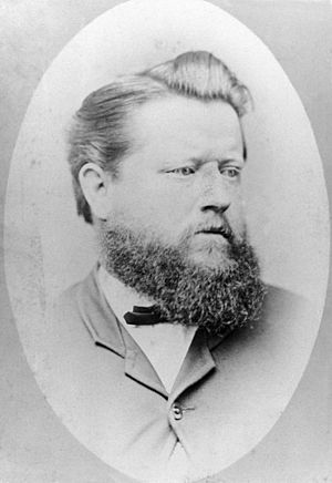
- Augustus Poeppel was born in Germany in 1839. He became a mining surveyor and architect. He joined the South Australian Lands Department in 1878 and worked on border surveys. His health suffered greatly during the surveys, and he lost sight in one eye. He passed away in 1891 at age 52.
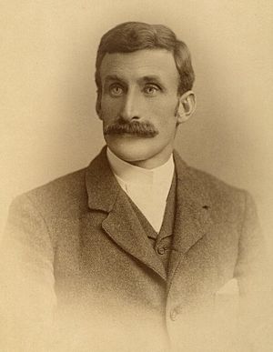
- Lawrence Wells was born in South Australia in 1860. He joined the Survey Department in 1878. At just 23, he helped survey almost the entire Queensland-South Australian-Northern Territory borders. He later became a famous explorer, known for leading expeditions that discovered goldfields and explored northern Western Australia. He was honored with the Order of the British Empire in 1937.
- Alexander Salmond was born in Scotland in 1850. He learned navigation in the British merchant navy. He became a licensed surveyor in 1878 and worked in remote parts of Australia. A river in the Kimberley region is named after him.
Haddon Corner Today
The surveyors faced huge challenges, but their work was amazing. Today, we use Global Positioning Systems (GPS) to find locations much more accurately. We now know that the exact spot at 26 degrees South and 141 degrees East is slightly different from where the original marker was placed. However, a law passed in 1982 confirmed that the borders marked on the ground before 1900 are the official ones. Also, the Earth's tectonic plates move slowly over time, which can change the exact longitude and latitude of a place.
The original wooden post at Haddon Corner has been replaced with a strong concrete pillar. This survey mark is protected by law. Haddon Corner is now a popular place for tourists to visit.
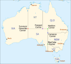
| Corners in Australia | |||||
|---|---|---|---|---|---|
| Name | Surveyor Generals | Poeppel | Haddon | Cameron | MacCabe |
| States | WA/NT/SA | NT/SA/Qld | SA/Qld | SA/Qld/NSW | SA/Vic/NSW |
What Haddon Corner Looks Like
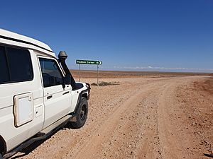
Haddon Corner is in south-western Queensland, right next to the border with South Australia. It is about 335 kilometres (208 mi) north of Cameron Corner and about 300 kilometres (190 mi) east of Poeppel Corner. The area is part of the Channel Country, with gentle slopes and drainage that flows towards Cooper Creek to the east and the Diamantina River to the west.
The actual point where 26 degrees South and 141 degrees East meet (which is not officially marked) is a few hundred meters south and a little east of the main Haddon Corner post. Like other Queensland borders, there's a small difference between the exact latitude/longitude and where the border fence or post is placed.
Why Haddon Corner is Important
Haddon Corner is listed on the Queensland Heritage Register because it meets several important rules:
Showing Queensland's History
Haddon Corner shows how important it was to clearly mark borders in Queensland's early history. Clear borders helped governments and farmers know where their land was. They also made it easier to collect customs duties, which were important for the economy. Haddon Corner is a great example of how Australian colonies worked together. It also shows the amazing effort it took to survey the Queensland-South Australia border.
A Great Achievement in Surveying
Haddon Corner represents a difficult but successful surveying achievement. It shows an early use of "geodetic surveying" in Queensland. This is a special type of surveying that considers the Earth's curved shape.
Important to the Community
Haddon Corner is a well-known place for many Australians. It is a geographical landmark and a popular spot for tourists to visit.
Connected to Important People
Haddon Corner has a strong link to the lives and work of Augustus Poeppel and Lawrence Allen Wells. These surveyors also worked on other important border surveys, including Poeppel Corner and the Queensland-Northern Territory border.
 | Kyle Baker |
 | Joseph Yoakum |
 | Laura Wheeler Waring |
 | Henry Ossawa Tanner |


