
Barringun, Queensland facts for kids
Quick facts for kids BarringunQueensland |
|||||||||||||||
|---|---|---|---|---|---|---|---|---|---|---|---|---|---|---|---|

Barringun
Location in Queensland
|
|||||||||||||||
| Population | 17 (2021 census) | ||||||||||||||
| • Density | 0.0182/km2 (0.047/sq mi) | ||||||||||||||
| Postcode(s) | 4490 | ||||||||||||||
| Area | 932.8 km2 (360.2 sq mi) | ||||||||||||||
| Time zone | AEST (UTC+10:00) | ||||||||||||||
| Location |
|
||||||||||||||
| LGA(s) | Shire of Paroo | ||||||||||||||
| State electorate(s) | Warrego | ||||||||||||||
| Federal Division(s) | Maranoa | ||||||||||||||
|
|||||||||||||||
Barringun is a small rural area in Queensland, Australia. It is located right on the border between Queensland and New South Wales. In 2021, only 17 people lived in Barringun.
A former town called Wooroorooka is also part of this area. It's located in the south-west of Barringun.
Geography
Barringun is bordered by the Warrego River to the west. The southern border is shared with New South Wales. A special marker called the Zero Obelisk stands here. It shows where the first official survey of the border began. This survey was very important for legal and economic reasons back in the 1800s. It reminds us how hard early surveyors worked in tough conditions.
Barringun Road runs through the area. It connects Cunnamulla, Queensland to Bourke, New South Wales. This road is part of the larger Mitchell Highway.
Most of the land in Barringun is used for grazing. This means farmers raise animals like sheep or cattle on the natural plants.
Binya National Park is just west of Barringun. It is located in a nearby area called Cuttaburra.
Barringun is also known as the capital of the self-proclaimed Murrawarri Republic.
The old town of Wooroorooka is now abandoned. It sits just north of the New South Wales border, near Owangowan Creek.
History
_Customs_Quarters,_1885.jpg)
The name Barringun comes from an Aboriginal word. It describes the lower part of the Warrego River. Some people say the word means fish die in the water.
Early European settlers built a station called Barringun on the Warrego River. An 1887 map shows it just south of the New South Wales border.
The name Wooroorooka came from a large farm (pastoral run). A man named Mr Dangar owned it in 1865. Later, James Tyson bought it in 1866.
In 1884, the Queensland Government sold many town lots in Wooroorooka.
Around 1885, there were talks about building a rabbit-proof fence. This fence would stop rabbits from spreading between the colonies.
Before Australia became one country in 1901, Wooroorooka was a border customs office for Queensland. A customs office checks goods crossing borders. Across the border, Barringun was the customs office for New South Wales. At that time, Wooroorooka had a customs officer, police, a teacher, and a postmaster.
The old customs house in Wooroorooka became a home for the border fence ranger. Wooroorooka also had its own police station.
Barringun helped support the surrounding farms. The shearing season was a very important time for jobs. The local creek provided water, even when it didn't rain much. People enjoyed fishing and playing cricket with nearby farms.
In the 1930s, the town continued to enjoy sports, including horse races.
There was a plan to build a railway line from Bourke to Barringun. This was in the late 1920s to 1940s. The idea was to connect it to Cunnamulla for moving goods. However, the Queensland Government didn't like this plan. They thought it would take trade and money away from Queensland.
By 1952, the road from Cunnamulla to the New South Wales border was sealed with bitumen. This made the railway plan less likely to happen. The road between Barringun and Bourke was expected to be sealed by 1971.
During 2020 and 2021, the Queensland border was closed. This was because of the COVID-19 pandemic. There were police checkpoints at places like Barringun. They checked if people were allowed to enter Queensland.
Demographics
In 2021, Barringun had a population of 17 people.
Heritage listing

Barringun has a special heritage-listed site. It's the Zero Obelisk on the east bank of the Warrego River. This obelisk marks the start of the first official survey of the border. It shows the boundary between what were then two separate colonies.
Education
There are no schools in Barringun itself. The closest primary and secondary schools are in Cunnamulla. This town is about 107 kilometers away. For students in Barringun, options include learning from home or going to a boarding school.
Writings
The old town of Barringun was featured in a poem from 1917. The poem was written by a Scottish-Australian poet named Will H. Ogilvie. He wrote about the dusty landscape and the small town.
Ogilvie knew the area well. He worked on a property called Belalie in the early 1890s. This property was near Enngonia, south of Barringun.
Another poem by Ogilvie, called Comrades, also mentions Barringun. It talks about shearers and cattle coming through the area.
Ogilvie also wrote a short story about the mail delivery to the town. It was called His Majesty's mail and was published in 1922.
Images for kids
-
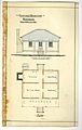
Architectural drawings of the Barringun Customs Quarters, 1885
-
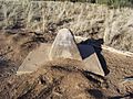
Zero Obelisk
