
Camiac-et-Saint-Denis facts for kids
Quick facts for kids
Camiac-et-Saint-Denis
|
||
|---|---|---|
 |
||
|
||

Camiac-et-Saint-Denis
Location in France

Camiac-et-Saint-Denis
Location in Nouvelle-Aquitaine
|
||
| Country | France | |
| Region | Nouvelle-Aquitaine | |
| Department | Gironde | |
| Arrondissement | Libourne | |
| Canton | Les Coteaux de Dordogne | |
| Intercommunality | Entre Deux Mers Ouest | |
| Area
1
|
6.6 km2 (2.5 sq mi) | |
| Population
(Jan. 2019)
|
360 | |
| • Density | 54.5/km2 (141.3/sq mi) | |
| Time zone | UTC+01:00 (CET) | |
| • Summer (DST) | UTC+02:00 (CEST) | |
| INSEE/Postal code |
33086 /33420
|
|
| Elevation | 28–114 m (92–374 ft) (avg. 62 m or 203 ft) |
|
| 1 French Land Register data, which excludes lakes, ponds, glaciers > 1 km2 (0.386 sq mi or 247 acres) and river estuaries. | ||
.svg)
Camiac-et-Saint-Denis is a small commune in France. A commune is like a small town or village with its own local government. It is located in the southwest part of the country.
Contents
About Camiac-et-Saint-Denis
This commune is a quiet place in the French countryside. It is known for its peaceful setting.
Where is Camiac-et-Denis?
Camiac-et-Saint-Denis is found in the Aquitaine region. This region is in the southwest of France. The commune is part of the Gironde department. The closest big city is Bordeaux.
How Many People Live Here?
As of January 2019, about 360 people live in Camiac-et-Saint-Denis. This makes it a very small community. The area of the commune is about 6.6 square kilometers.
Who is in Charge?
The mayor of Camiac-et-Saint-Denis is André Tite. The mayor is the head of the local government. They help manage the commune's services. These services include things like roads and local events.
What's the Land Like?
The land in Camiac-et-Saint-Denis varies in height. The lowest point is 28 meters (about 92 feet) above sea level. The highest point is 114 meters (about 374 feet) above sea level. The average height is 62 meters (about 203 feet).
Images for kids
-
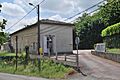
The town hall of Camiac-et-Saint-Denis.
-
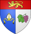
The coat of arms for Camiac-et-Saint-Denis.
See also
 In Spanish: Camiac-et-Saint-Denis para niños
