
Campobello Island facts for kids
Quick facts for kids
Campobello Island
Île Campobello
|
|
|---|---|
|
Rural community
|
|

Head Harbour Lighthouse and station, Passamaquoddy Bay
|
|

Campobello Island
Location in Canada

Campobello Island
Location in New Brunswick
|
|
| Country | Canada |
| Province | New Brunswick |
| County | Charlotte County |
| Erected | 1803 |
| Area | |
| • Land | 39.59 km2 (15.29 sq mi) |
| Highest elevation | 90 m (300 ft) |
| Lowest elevation | 0 m (0 ft) |
| Population
(2021)
|
|
| • Total | 949 |
| • Density | 24/km2 (60/sq mi) |
| • Pop 2016-2021 | |
| • Pop 2016-2021 density | 24/km2 (60/sq mi) |
| • Dwellings | 612 |
| Time zone | UTC-4 (AST) |
| • Summer (DST) | UTC-3 (ADT) |
Campobello Island is a beautiful island in New Brunswick, Canada. It is the largest and only island where people live in the area called Campobello. This island is very close to the border with Maine, United States. In 2021, about 949 people lived here.
Campobello Island is famous for a few cool places. These include the Roosevelt Campobello International Park, the Head Harbour Lighthouse, and Herring Cove Provincial Park. Since 2010, Campobello Island has been a "rural community." This means it has its own local government. The community of Campobello also includes some smaller islands nearby.
Contents
What's in a Name?
Have you ever wondered how places get their names? In 1770, a man named Captain William Owen was given the entire island. He cleverly made the island seem smaller than it was to get around rules about land size. Owen then renamed the island "Campobello." This was a playful way to honor Lord William Campbell, who was the Governor of Nova Scotia at the time. Later, the whole area around the island was named Campobello Parish after the island itself.
Island History

Long before Europeans arrived, the Passamaquoddy Nation lived on the island. They called it Ebaghuit.
The first Europeans to visit were French explorers in 1604. Pierre Dugua de Mons and Samuel de Champlain set up a settlement nearby on Saint Croix Island. The French called Campobello Island "Port aux Coquilles," which means "Seashell Harbour."
After a big war called the War of the Spanish Succession, the island became part of the British colony of Nova Scotia in 1713.

More people, known as United Empire Loyalists, moved to the island after the American Revolutionary War. These were people who stayed loyal to Britain. For a while, smuggling was a big part of how people made money on the island.
During the War of 1812, British ships took control of some coastal lands in Maine. After the war, these lands were returned, but the islands offshore, including Campobello, stayed with Britain. In 1817, the United States officially gave up its claim to Campobello, Deer Island, and Grand Manan islands. In return, they got other islands in Cobscook Bay.
To help ships navigate, the government of New Brunswick built the Head Harbour Lighthouse (also called East Quoddy Head Light) in 1829. This lighthouse worked with the West Quoddy Head Light that the United States had built earlier.
In 1866, a large group of over 700 men called the Fenian Brotherhood tried to take over Campobello Island. They arrived on the Maine shore across from the island, but British warships from Halifax quickly stopped them.

In 1857, a British naval officer named John James Robinson became the owner of the island. Then, in 1881, he sold it to a group of American businessmen, including James Roosevelt. In the 1880s, Campobello Island became a popular summer spot for rich Canadians and Americans. Many fancy hotels and large homes were built. The famous Roosevelt family started spending their summers on Campobello Island from 1883 onwards.
By the mid-1800s, over 1,000 people lived on Campobello Island. This number grew to 1,230 by 1910.
Campobello Parish History
In 1803, Campobello Island became its own special area called Campo-Bello Parish. This separated it from another area called West Isles Parish. The exact borders of the parish were made clearer in 1877.
Over the years, the name of the parish was sometimes spelled "Campo Bello" in official documents. But by 1903, it was officially spelled "Campobello."
In 2010, the entire parish became the Rural Community of Campobello Island. This means it now has its own local government to manage services for the people living there.
Island Geography
Campobello Island is located at the entrance to Passamaquoddy Bay, which is part of the larger Bay of Fundy. It's one of the islands in the Fundy Bay.
The island is about 14 kilometers (9 miles) long and 5 kilometers (3 miles) wide. Its total area is about 39.6 square kilometers (15.3 square miles). On the north side, there's a high cliff called East Quoddy Point. On the west side, you'll find Charley Point and the Mulholland Point navigation light.
Getting to Campobello Island
It's interesting that Campobello Island doesn't have a direct road connection to the rest of Canada! You can drive to the island from Lubec, Maine, in the United States, by crossing the Franklin Delano Roosevelt Bridge.
If you want to reach mainland Canada by car without crossing into the U.S., you have to take two different ferry rides. First, you take a ferry to nearby Deer Island, and then another ferry from Deer Island to L'Etete on the Canadian mainland. This ferry service to Deer Island used to stop in the winter, but because of the COVID-19 pandemic, it now runs all year round.
Island Economy
Campobello Island has several good harbors. Most people who live on the island work in fishing, aquaculture (which is like fish farming), or tourism.
The two most popular places for visitors on the island are Herring Cove Provincial Park and Roosevelt Campobello International Park. The Roosevelt Campobello International Park was created in 1964. It was officially opened in 1966 by U.S. President Lyndon Johnson and Canadian Prime Minister Lester Pearson.
Island Infrastructure
The island's only main road, Route 774, connects to Lubec, Maine, via the Franklin Delano Roosevelt Bridge. As mentioned, the only way to get to the rest of Canada by car is by taking a seasonal ferry to Deer Island.
Even mail delivered to Campobello Island often goes through the United States. In 2019, U.S. border officials started searching packages going to and from the island. This caused some concern among residents and was even discussed in the House of Commons of Canada, because people worried about their privacy and Canada's control over its own land.
In late 2020, people on the island again asked the Canadian government to build a bridge to the New Brunswick mainland. This is because the current ferry can't always run in winter due to bad weather. During the COVID-19 pandemic, the border closure made it very hard to drive to and from the island, except for essential reasons. This showed how important a year-round connection is.
The government agreed to pay for the ferry service to continue longer, but islanders still feel a bridge or a permanent ferry is needed.
Education
The island has one school, Campobello Island Consolidated School. This school teaches students of all ages, from the youngest grades up to high school. It is part of the Anglophone South School District.
Island Communities
Here are some of the smaller communities within the rural community of Campobello Island:
- North Road
- Otter Cove
- Welshpool
- Wilsons Beach
Bodies of Water
These are some of the bays, lakes, and streams found on or around Campobello Island:
- Friars Bay
- Lake Glensevern
- Harbour de Lute
- Head Harbour
- Head Harbour Passage
- Lubec Channel
- Lubec Narrows
- Mill Cove Creek
- Mill Stream
- Quoddy Narrows
- Passamaquoddy Bay
Other Islands Nearby
Besides Campobello, here are some other named islands in the area:
- Duck Islands
- Duck Rock
- Head Harbour Island
- Little Island
- Sugar Loaf Rock
Parks and Protected Areas
These are special areas on the island set aside for nature and recreation:
- Herring Cove Provincial Park
- Roosevelt Campobello International Park
Images for kids
-
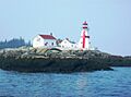
Head Harbour Lighthouse and station, Passamaquoddy Bay
-
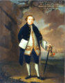
Captain William Owen.
-
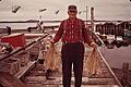
Campobello fisherman in 1973
-
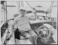
Franklin D. Roosevelt on Campobello, 1933
See also
 In Spanish: Isla Campobello para niños
