
Cape Arkona facts for kids

Cape Arkona is a cool spot on the island of Rügen in Germany. It's a 45-meter (about 150-foot) high cliff that sticks out into the sea. This cape is at the very tip of the Wittow peninsula. It's a super popular place for tourists, with around 800,000 people visiting every year!
At Cape Arkona, you'll find two lighthouses, an old navigation tower, and some old military bunkers. There's also the remains of an ancient Slavic temple fortress called Jaromarsburg. Plus, there are restaurants, shops, and places to grab a snack.
The cliffs here can sometimes crumble, especially in winter, because of the weather and how the land is formed. Even though many people think Cape Arkona is the northernmost point of Rügen, it's actually not! There's a spot called Gellort about a kilometer to the northwest that's a tiny bit further north. At the bottom of Gellort, there's a huge 165-ton rock called the Siebenschneiderstein.
Contents
The smaller lighthouse was built a long time ago, in 1826/27. It was designed by a famous architect named Karl Friedrich Schinkel. This lighthouse is about 19.3 meters (63 feet) tall. It started working in 1828 but stopped being used in 1905. It's the second oldest lighthouse on Germany's Baltic Sea coast! People sometimes call it the Schinkelturm ("Schinkel Tower").

The bigger lighthouse was built right next to the old one in 1901/02. It's much taller, at 35 meters (115 feet). It started guiding ships in 1905. For 90 years, it used special lights called arc lamps. But in 1995, they were updated to a modern Metal-halide lamp. This light flashes three times every 17 seconds, helping ships find their way.
There's also an old naval navigation tower, built in 1927. It used to send out radio waves to help ships navigate, especially the Sassnitz-Trelleborg railway ferry. Its technical equipment was destroyed in 1945.
All three towers were fixed up in the early 1990s. Now, you can visit them! The old lighthouse has a museum inside. You can even get married there! The navigation tower is now an art museum and studio. From the top of each tower, you get amazing views of Rügen and even the Danish island of Møn on a clear day.
Jaromarsburg: Ancient Temple Fortress

From the 800s to the 1100s, the Jaromarsburg was a very important religious place for the Rani, a Slavic tribe. They worshipped their god Svantevit here. The fortress was built right at the tip of the cape. Cliffs protected it on three sides, and a huge 25-meter-high wall (called a burgwall) protected it from the land side.
The temple inside these walls became even more important after another Slavic religious center was destroyed in 1068. But in 1168, the Danish king Valdemar I conquered Rügen. The island then became Christian, and the temple and fortress were destroyed.
Over the years, parts of the cliffs at Arkona have fallen into the sea. Because of this, today you can only see the remains of the old walls of the Jaromarsburg.
Steps to the Beach: King's and Violet Staircases

A bit west of Cape Arkona, you'll find the Königstreppe ("King's Staircase"). It has 230 steps that go down the 42-meter-high cliff.
Long ago, when Rügen belonged to Sweden, the Swedish king Frederick I had a warning signal put up near these steps during a war. That's why the area was known as the "King's Climb."
Later, in 1833, the Prussian king Frederick William III (Rügen was Prussian then) had a landing spot and steps built here. This was for a special steamboat expedition. In 1865, the first telegraph cable under the Baltic Sea to Sweden was laid from this very spot! As tourism grew, many visitors came by boat and landed at the pier here. However, a big storm in 1953 completely destroyed the landing stage. The new Königstreppe steps were finished in 1995, built in the same historic spot.
South of the Jaromarsburg ruins, there's another path to the beach called the Veilchentreppe ("Violet Staircase"). It gets its name from the beautiful violets that grow around the steps in spring.
Bunkers: Hidden History

Close to the lighthouses, there are two old bunkers. The smaller, older one was built during Wehrmacht times (Germany's armed forces before and during World War II). Later, during the time of East Germany (GDR), it was used by border guards. It's usually called the Arkona Bunker.

The bigger, newer bunker was built between 1979 and 1986. It was a command center for the East German navy, the Volksmarine ("People's Navy"). This bunker complex is huge, with a total area of 2,000 square meters! It has a main tunnel with two entrances and many separate bunker rooms. These rooms were made from strong concrete parts. Some even had sleeping areas and emergency exits.
In 1985, a picture book about the East German army (NVA) accidentally showed an aerial photo of Cape Arkona with the unhidden bunker complex. This was a big secret, so the book was quickly taken off shelves! Today, that original book is a rare collector's item.
From 1986, 50 to 70 soldiers from the Volksmarine would train here several times a year. The bunkers were closed on October 3, 1990, when Germany became one country again.
Today, the bunkers have been bought and fixed up. The Arkona Bunker now has an art gallery. The NVA Bunker has an exhibition showing equipment from East Germany and photos about the Volksmarine.
How to Get There

If you want to visit Cape Arkona, you'll need to park your car or bus at a large car park just outside the village of Putgarten. From there, you can walk to the cape (it's about 1.8 kilometers or just over a mile). You can also take a horse and carriage or ride the Cape Arkona road train. Bicycles are also a great way to explore the area.
Since 1993, the Cape Arkona Train has taken visitors from Putgarten to the cape and the nearby fishing village of Vitt. Even though it's called a "train," it doesn't run on tracks! It's a road train that looks like an old steam locomotive but runs on wheels on regular roads. Since 1996, it's been powered by an environmentally friendly gas engine.
You can also get to Cape Arkona by boat! Ships run daily from the towns of Binz and Sassnitz to the cape.
Climate
-Deutschland.png)
The weather at Cape Arkona is typical for the coast of North Vorpommern. The average temperature for the whole year is about 7.9 degrees Celsius (around 46 degrees Fahrenheit). It gets about 521 millimeters (20.5 inches) of rain each year. Because it's so close to the sea, the air is often very humid.
Maritime Connections
- Ships

Some ships have been named after Cape Arkona:
- The German luxury ocean liner, SS Cap Arcona, launched in 1927.
- The cargo ship, Kap Arkona, which belonged to a German shipping company.
- The rescue cruiser, Arkona, used by the German Maritime Search and Rescue Service.
- Other
There's also a big offshore wind farm called Arkona being built about 35 kilometers (22 miles) northeast of the cape. It will have 60 huge wind turbines to generate clean energy!
Gallery
-
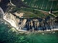
Cape Arkona from the air
-
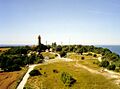
View from the navigation tower


See also
- Pomerania during the Early Middle Ages
- Pomerania during the Late Middle Ages
- Conversion of Pomerania
- Rugii (Germanic Tribe)
- Rani (Slavic tribe)
- Principality of Rügen
