
Cape Chidley Islands facts for kids

Cape Chidley Islands area
|
|

Cape Chidley Islands
Location in Nunavut

Cape Chidley Islands
Location in Canada
|
|
| Geography | |
|---|---|
| Location | Labrador Sea |
| Coordinates | 60°25′45″N 64°27′50″W / 60.42917°N 64.46389°W |
| Archipelago | Canadian Arctic Archipelago |
| Area | 10 km2 (3.9 sq mi) |
| Highest point | 401 m (1,316 ft) |
| Administration | |
| Nunavut | Nunavut |
| Region | Qikiqtaaluk |
| Demographics | |
| Population | Uninhabited |
| Source: Cape Chidley Islands at the Atlas of Canada | |
The Cape Chidley Islands are a group of islands in Nunavut, Canada. They are part of the Canadian Arctic Archipelago. These islands are found in the Labrador Sea. They are located at the southern entrance to the Hudson Strait. The islands are north of Killiniq Island's Cape Chidley. The MacGregor Strait separates them from Killiniq Island.
What are the Cape Chidley Islands?
The Cape Chidley Islands are made up of two main islands. These are Cabot Island and Pert Island. Both islands are uninhabited, meaning no one lives there. They are known for their rugged, natural beauty.
Cabot Island
Cabot Island is the island located to the east. It is about 2 miles (3.2 km) long. This island has two high points, or summits. The northern summit is 401 meters (1,316 feet) above sea level. The southern summit is 325 meters (1,066 feet) high.
Pert Island
Pert Island is the smaller of the two islands. It lies about 0.5 miles (0.8 km) to the west of Cabot Island. The highest point on Pert Island is 385 meters (1,263 feet) above sea level. The community of Port Burwell is located about 20 kilometers (12 miles) west of Pert Island.
Images for kids
-
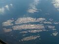
Button Islands in July. This view is from the northwest looking southeast. Killiniq Island is barely visible in the upper right. The Cape Chidley Islands are just outside this photo, beyond Knight Island.
.jpg)
