Capel, Western Australia facts for kids
Quick facts for kids CapelWestern Australia |
|
|---|---|

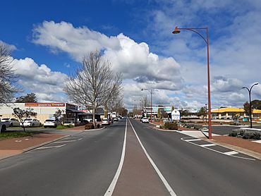
Forrest Road in Capel
|
|
| Established | 1897 |
| Postcode(s) | 6271 |
| Elevation | 19 m (62 ft) |
| Area | [convert: needs a number] |
| Location | |
| LGA(s) | Shire of Capel |
| State electorate(s) | Collie-Preston |
| Federal Division(s) | Forrest |
Capel is a town in the South West region of Western Australia. It is about 212 kilometers (132 miles) south of Perth. Capel sits between the towns of Bunbury and Busselton. The town is built on the Capel River. It is about 19 meters (62 feet) above sea level.
Contents
History of Capel
The land around Capel was first home to the Wardandi Noongar people. They lived here for thousands of years.
Early European Visits
European settlers visited this area very early. Frederick Ludlow explored the Capel River in 1834. The river got its English name soon after. This happened when the Bussell family settled nearby. The town's name honors Capel Carter Brockman (1839–1924). She was the daughter of John Bussell. She was named after a cousin of the Bussells in England.
Town Development
Many settlers followed the Bussells to the area in the 1830s. Even the first two Governors of Western Australia, James Stirling and John Hutt, owned land here. Plans for a townsite began in 1844. However, the land was not measured until the 1870s. Town lots were first sold in 1897. The town was first called Coolingnup. This was the Noongar name for the place. The name was changed to Capel in 1899.
Climate in Capel
Capel has a hot-summer Mediterranean climate. This means it has hot, dry summers. It also has cool, wet winters.
Temperature and Rainfall
In summer, daily temperatures range from 13°C (55°F) to 40°C (104°F). In winter, temperatures are from 5°C (41°F) to 27°C (81°F). The town gets about 830 millimeters (33 inches) of rain each year.
Capel's Population
In 1898, the town of Capel had 91 people. There were 44 males and 47 females.
Recent Population Figures
According to the 2016 census, the town of Capel had 2,509 people. The whole Shire of Capel had a population of 17,123.
Capel's Economy
For a long time, Capel was a farming area. Farmers traditionally raised dairy cows and beef cattle.
Modern Agriculture
Recently, Capel has become popular for hobby farms. These are smaller farms for fun or special crops. New types of farming have also started. These include raising alpacas and growing grapes for wine (called viticulture). People also farm fish (called aquaculture) and grow blue gum trees.
Mining and Tourism
The Shire of Capel also has some mining of mineral sands. These are special sands that contain valuable minerals. Tourism is also becoming more important. Many visitors come to see the area's natural beauty.
Mineral Sands Mining History
Westralian Sands started in 1954. They began mining in 1959. They worked at the Yoganup deposit, just north of Capel. Another company, RGC, had a mine south of the town. In 1998, these two companies joined together. They formed Iluka Resources. This company still mines ilmenite around Capel. They also make synthetic rutile at a processing plant north of town. This plant is located along the Bussell Highway.
 | Selma Burke |
 | Pauline Powell Burns |
 | Frederick J. Brown |
 | Robert Blackburn |


