Carp Lake Township, Ontonagon County, Michigan facts for kids
Quick facts for kids
Carp Lake Township, Michigan
|
|
|---|---|

|
|

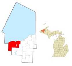
Location within Ontonagon County (red) and the administered community of White Pine (pink)
|
|
| Country | United States |
| State | Michigan |
| County | Ontonagon |
| Area | |
| • Total | 225.59 sq mi (584.3 km2) |
| • Land | 224.84 sq mi (582.3 km2) |
| • Water | 0.75 sq mi (1.9 km2) |
| Elevation | 1,027 ft (313 m) |
| Population
(2020)
|
|
| • Total | 582 |
| • Density | 3.21/sq mi (1.24/km2) |
| Time zone | UTC-5 (Eastern (EST)) |
| • Summer (DST) | UTC-4 (EDT) |
| ZIP code(s) | |
| Area code(s) | 906 |
| FIPS code | 26-13520 |
| GNIS feature ID | 1626034 |
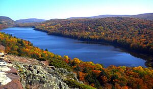
Carp Lake Township is a special area located in Ontonagon County, in the state of Michigan. It's called a civil township, which is a type of local government area. In 2020, about 582 people lived here. A large part of the amazing Porcupine Mountains Wilderness State Park is found right within this township!
Did you know that Carp Lake Township is the westernmost place in the United States that uses Eastern Standard Time? That's a pretty cool fact!
Exploring Carp Lake Township
This township covers a total area of about 225.59 square miles (584.28 square kilometers). Most of this area, about 224.84 square miles (582.33 square kilometers), is land. The rest is water.
Water and Shoreline
A significant part of Carp Lake Township has a shoreline along the beautiful Lake Superior. Imagine living so close to one of the largest freshwater lakes in the world!
Local Communities
Carp Lake Township is home to a couple of interesting communities:
- Carp Lake is a community that started way back in 1858. It grew up around a copper mine.
- White Pine is another community in the township. It's known as a census-designated place, which means it's an area identified by the census bureau for statistics.
See also
 In Spanish: Municipio de Carp Lake (condado de Ontonagon) para niños


