Carriage Club, Colorado facts for kids
Quick facts for kids
Carriage Club, Colorado
|
|
|---|---|

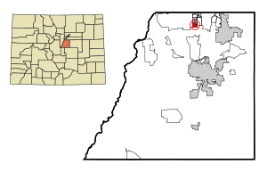
Location of Carriage Club in Douglas County, Colorado.
|
|
| Country | |
| State | |
| County | Douglas County |
| City | City of Lone Tree |
| Elevation | 6,014 ft (1,833 m) |
| Population
(2000)
|
|
| • Total | 1,002 |
| Time zone | UTC-7 (MST) |
| • Summer (DST) | UTC-6 (MDT) |
| ZIP code |
Lone Tree 80124
|
| Area codes | 303 & 720 |
| GNIS feature | Carriage Club, Colorado |
Carriage Club is a neighborhood located in the City of Lone Tree, Douglas County, Colorado, in the United States. It used to be known as a "census-designated place" (CDP). This means it was an area set up just for counting people during a census. In the year 2000, about 1,002 people lived there.
Geography
Carriage Club is found in a specific spot in Colorado. Its exact location is at 39.532 degrees North and 104.901 degrees West. This is like giving its address on a map using special numbers. The neighborhood sits at an elevation of about 1,833 meters (or 6,014 feet) above sea level.
See also
 In Spanish: Carriage Club para niños

All content from Kiddle encyclopedia articles (including the article images and facts) can be freely used under Attribution-ShareAlike license, unless stated otherwise. Cite this article:
Carriage Club, Colorado Facts for Kids. Kiddle Encyclopedia.
