Carson City, Michigan facts for kids
Quick facts for kids
Carson City, Michigan
|
|
|---|---|

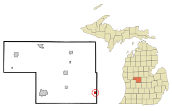
Location within Montcalm County and the state of Michigan
|
|
| Country | United States |
| State | Michigan |
| County | Montcalm |
| Government | |
| • Type | Mayor-council government |
| Area | |
| • Total | 1.17 sq mi (3.04 km2) |
| • Land | 1.14 sq mi (2.96 km2) |
| • Water | 0.03 sq mi (0.08 km2) |
| Elevation | 761 ft (232 m) |
| Population
(2020)
|
|
| • Total | 1,120 |
| • Density | 979.02/sq mi (378.16/km2) |
| Time zone | UTC-5 (Eastern (EST)) |
| • Summer (DST) | UTC-4 (EDT) |
| ZIP code |
48811
|
| Area code(s) | 989 |
| FIPS code | 26-13600 |
| GNIS feature ID | 1626036 |
Carson City is a small city in Montcalm County, located in the state of Michigan in the United States. In 2020, about 1,120 people lived there. It's a friendly community with a rich history.
Contents
History of Carson City
Carson City was first planned out in 1866. This means people decided where streets and buildings would go. The first piece of land was sold in 1867 to Thomas Scott and his nephews, John and Thomas LaDue.
They started a sawmill in 1868 and a grist mill (for grinding grain) in 1870. The post office moved to this spot in 1868. Thomas Scott named the town "Carson City" because he had visited Carson City, Nevada, during its gold and silver mining boom. Carson City officially became a village in 1887 and a city in 1960. John T. Hallett was the first mayor.
Geography and Location
Carson City is in the southeastern part of Montcalm County. It is surrounded by Bloomer Township on three sides and North Shade Township to the east.
The state highway M-57 goes right through the city, acting as its Main Street. You can drive west about 20 miles to Greenville or east about 37 miles to Chesaning. Stanton, which is the main town of Montcalm County, is about 20 miles northwest.
Carson City covers about 1.17 square miles. Most of this area is land, with a small part being water. Fish Creek, a stream that flows into the Maple River, runs along the western edge of the city. This creek is part of a larger water system that eventually leads to Lake Michigan.
People of Carson City
| Historical population | |||
|---|---|---|---|
| Census | Pop. | %± | |
| 1880 | 709 | — | |
| 1890 | 921 | 29.9% | |
| 1900 | 906 | −1.6% | |
| 1910 | 808 | −10.8% | |
| 1920 | 973 | 20.4% | |
| 1930 | 972 | −0.1% | |
| 1940 | 1,112 | 14.4% | |
| 1950 | 1,168 | 5.0% | |
| 1960 | 1,201 | 2.8% | |
| 1970 | 1,217 | 1.3% | |
| 1980 | 1,229 | 1.0% | |
| 1990 | 1,158 | −5.8% | |
| 2000 | 1,190 | 2.8% | |
| 2010 | 1,093 | −8.2% | |
| 2020 | 1,120 | 2.5% | |
| U.S. Decennial Census | |||
Population in 2010
In 2010, there were 1,093 people living in Carson City. These people lived in 451 households, with 271 of them being families. The city had about 1,051 people per square mile.
Many households included children under 18. About 40% of households were married couples. The average age of people in Carson City was around 41.8 years old. About 24% of residents were under 18, and another 24% were 65 or older.
Local Services and Facilities
The Carson City post office serves the city and nearby areas. Its ZIP code is 48811.
The nearest airport, Mayes Airport, is about 4.3 miles away. However, it is now closed.
Education
Students in Carson City attend schools run by the Carson City-Crystal Area Schools district. This district has a lower elementary school, a combined upper elementary and middle school, and a high school. The school mascot is the eagle.
Famous People from Carson City
- Orson Baldwin (1881–1942), a professional baseball player for the St. Louis Cardinals.
- Daniel Henney (born 1979), a well-known actor and model.
- Bill Knot (1940–2014), a famous poet.
- William C. Lawe (1910–1942), a United States Navy sailor who received the Distinguished Flying Cross during World War II.
See also
 In Spanish: Carson City (Míchigan) para niños
 | May Edward Chinn |
 | Rebecca Cole |
 | Alexa Canady |
 | Dorothy Lavinia Brown |

