
Casco, Maine facts for kids
Quick facts for kids
Casco, Maine
|
|
|---|---|

Casco village from the air with Pleasant Lake in the background
|
|

Location in Cumberland County and the state of Maine.
|
|
| Country | |
| State | |
| County | Cumberland |
| Incorporated | 1841 |
| Villages | Casco Cook Mills Crescent Lake Pike Corner South Casco |
| Area | |
| • Total | 38.01 sq mi (98.45 km2) |
| • Land | 31.24 sq mi (80.91 km2) |
| • Water | 6.77 sq mi (17.53 km2) |
| Elevation | 545 ft (166 m) |
| Population
(2020)
|
|
| • Total | 3,646 |
| • Density | 117/sq mi (45.1/km2) |
| Time zone | UTC−5 (Eastern (EST)) |
| • Summer (DST) | UTC−4 (EDT) |
| ZIP Codes |
04015 (Casco)
04077 (South Casco) |
| Area code(s) | 207 |
| FIPS code | 23-11125 |
| GNIS feature ID | 0582395 |
Casco is a small town in Maine, United States. It is located in Cumberland County. In 2020, about 3,646 people lived there.
Casco includes a few smaller areas called villages. These are Casco, South Casco, and Cook Mills. The town is right next to the eastern side of Sebago Lake. Part of Sebago Lake State Park is also in Casco.
Casco is about 30 miles (48 km) from downtown Portland. Every year, Casco hosts a fun event called "Casco Days." It's a community fair that happens on the last Saturday in July.
Contents
History of Casco
Casco has an interesting history that goes back a long time.
How Casco Became a Town
In 1767, the area was given to Captain William Raymond and his soldiers. This was a reward for their service in a battle in 1690. At first, it was called Raymondtown Plantation.
In 1803, Raymondtown Plantation officially became the town of Raymond. Later, in 1838, some land was taken from Raymond to create the town of Naples.
The western part of Raymond wanted to become its own town. This was because it was separated by Rattlesnake Mountain. After a few tries, their request was approved. On March 18, 1841, Casco officially became its own town.
Early Life and Industries
The land in Casco was a bit rocky, but farmers could still grow crops. The town had many ponds and rivers. These were important because they provided power for mills.
In the past, Casco had many different types of mills. There were sawmills for cutting wood and gristmills for grinding grain. There were also factories that made things like barrels and roof shingles. A carriage factory and a tannery (for making leather) also existed.
Trade and Tourism
In 1832, the Cumberland and Oxford Canal opened. This canal connected Sebago Lake directly to Portland. It made it easier to trade goods.
In the 1840s, steamboats started traveling on the waterways. These boats carried both tourists and goods. This helped Casco become a place for visitors. In 1938, Sebago Lake State Park was created. It was one of the first state parks in Maine.
| Historical population | |||
|---|---|---|---|
| Census | Pop. | %± | |
| 1850 | 1,046 | — | |
| 1860 | 1,116 | 6.7% | |
| 1870 | 998 | −10.6% | |
| 1880 | 908 | −9.0% | |
| 1890 | 844 | −7.0% | |
| 1900 | 783 | −7.2% | |
| 1910 | 688 | −12.1% | |
| 1920 | 685 | −0.4% | |
| 1930 | 713 | 4.1% | |
| 1940 | 890 | 24.8% | |
| 1950 | 881 | −1.0% | |
| 1960 | 947 | 7.5% | |
| 1970 | 1,256 | 32.6% | |
| 1980 | 2,243 | 78.6% | |
| 1990 | 3,018 | 34.6% | |
| 2000 | 3,469 | 14.9% | |
| 2010 | 3,742 | 7.9% | |
| 2020 | 3,646 | −2.6% | |
| U.S. Decennial Census | |||
Geography of Casco
Casco covers a total area of about 38 square miles (98 square kilometers). Most of this is land, and about 6.77 square miles (17.53 square kilometers) is water. The town has two main rivers: the Crooked River and the Songo River.
Neighboring Towns and Villages
Casco shares borders with several other towns. These include Raymond to the southeast, Naples and Otisfield to the northwest, and Poland to the northeast.
The main village of Casco is in the northern part of the town. South Casco is in the southeast, near Sebago Lake. Cook Mills is located near the western border of the town.
Population of Casco
Every ten years, the United States counts its population in a census. This helps us understand how many people live in a place and what they are like.
Casco's Population in 2010
In 2010, there were 3,742 people living in Casco. These people lived in 1,554 households. A household is like a home where people live together.
Most of the people in Casco were White (97%). About 29.7% of households had children under 18 living with them. The average age of people in Casco was about 42.6 years old.
Transportation in Casco
Casco has several important roads that help people travel around.
 Maine State Route 11: This is the longest state highway in Maine. It's often used by trucks, especially those carrying lumber. Locally, it's known as Poland Springs Road.
 Maine State Route 35: Route 35 runs next to Route 302 through the Casco area. It then goes north towards Harrison along Long Lake.
 Maine State Route 85: This road is about 8 miles (13 km) long. It connects Route 302 and Route 11. It starts near Sebago Lake and goes through Raymond.
 Maine State Route 121: Known as Meadow Road, this route begins at Route 302 near Sebago Lake. It goes through downtown Casco.
 US Route 302: This is a very important road in the lakes region. It's called Roosevelt Trail locally. It provides a direct way to get to Portland and other large towns in Maine.
Fun Places to Visit in Casco
Casco has many interesting places to see and visit:
- Raymond-Casco Historical Society, Museum at Watkins Farm on Route 302 in Casco
- Nathaniel Hawthorne's boyhood home in Raymond
- Sebago Lake State Park
- Netop Summer Camp
- Seeds of Peace international camp
- Camp Laurel South
- Camp Cedar
- Point Sebago Resort
Notable People from Casco
Here are some well-known people who have connections to Casco:
- Luther Gulick, a doctor and a member of the Basketball Hall of Fame
- William LeMessurier, a structural engineer
- Bonnie Titcomb Lewis, a state legislator
- Tony Montanaro, a mime artist
- Susan Augusta Pike Sanders, a teacher, clubwoman, and author
Images for kids
-
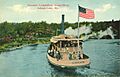
Steamer Longfellow on the Songo River in 1912

See also
 In Spanish: Casco (Maine) para niños
