Cassville, Missouri facts for kids
Quick facts for kids
Cassville, Missouri
|
|
|---|---|

Location of Cassville, Missouri
|
|
| Country | United States |
| State | Missouri |
| County | Barry |
| Township | Flat Creek |
| Area | |
| • Total | 3.42 sq mi (8.87 km2) |
| • Land | 3.42 sq mi (8.86 km2) |
| • Water | 0.00 sq mi (0.00 km2) |
| Elevation | 1,319 ft (402 m) |
| Population
(2020)
|
|
| • Total | 3,190 |
| • Density | 931.93/sq mi (359.86/km2) |
| Time zone | UTC-6 (Central (CST)) |
| • Summer (DST) | UTC-5 (CDT) |
| ZIP codes |
65623, 65625
|
| Area code(s) | 417 |
| FIPS code | 29-11890 |
| GNIS feature ID | 2393769 |
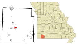
Cassville is a city located in Barry County, Missouri, United States. It's found within Flat Creek Township. In 2020, about 3,190 people lived there. Cassville is an important place for jobs and shopping for many people in the surrounding area. It is also the main government center, or county seat, for Barry County.
Contents
History of Cassville
How Cassville Started
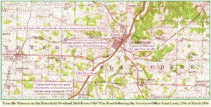
The area where Cassville is today was first planned out in 1845. A post office was also set up that same year. The town was named after Lewis Cass, who was a famous United States Senator and Secretary of War. Cassville was built along an old road called the Old Wire Road. This road connected Jefferson Barracks in Saint Louis, Missouri, to Fort Smith, Arkansas. It was also a stop on the Butterfield Overland Mail Route, which was a way to deliver mail and passengers across the country. Cassville officially became a city on March 3, 1847.
Cassville During the Civil War
For a short time during the American Civil War, Cassville was the capital of Missouri for the Confederate side. This was from October 29 to November 7, 1861. However, this didn't last long. The Union army pushed the Confederate government further south into Arkansas. Later, the Battle of Pea Ridge helped the Union keep control of Missouri.
Transportation and Historic Sites
Cassville was connected by a railroad called the Cassville & Exeter Railroad. This train line ran from July 4, 1896, until September 11, 1956.
Several important places in and around Cassville are listed on the National Register of Historic Places. This list includes the Cassville Ranger Station Historic District, the Natural Bridge Archaeological Site, and six different spots in Roaring River State Park. These places are protected because they are important to history or culture.
Population Information
| Historical population | |||
|---|---|---|---|
| Census | Pop. | %± | |
| 1870 | 287 | — | |
| 1890 | 626 | — | |
| 1900 | 702 | 12.1% | |
| 1910 | 781 | 11.3% | |
| 1920 | 1,002 | 28.3% | |
| 1930 | 1,016 | 1.4% | |
| 1940 | 1,214 | 19.5% | |
| 1950 | 1,441 | 18.7% | |
| 1960 | 1,451 | 0.7% | |
| 1970 | 1,910 | 31.6% | |
| 1980 | 2,091 | 9.5% | |
| 1990 | 2,371 | 13.4% | |
| 2000 | 2,890 | 21.9% | |
| 2010 | 3,266 | 13.0% | |
| 2020 | 3,190 | −2.3% | |
| U.S. Decennial Census | |||
Cassville's Population in 2010
In 2010, the city of Cassville had 3,266 people living there. There were 1,275 homes, with 848 of them being families. The city had about 1,402 housing units in total.
Most of the people living in Cassville in 2010 were of European American background (93.8%). There were also smaller groups of African American, Native American, and Asian residents. About 4.6% of the population identified as Hispanic or Latino.
The average age of people in Cassville was 40.5 years old. About 23.8% of the residents were under 18 years old.
Education in Cassville
The Cassville R-IV School District runs the schools in the city. This includes one elementary school, one middle school, one intermediate school, and Cassville High School.
Cassville also has a public library. It is part of the Barry-Lawrence Regional Library system.
For students looking for higher education, Crowder College offers two-year degree programs right in Cassville.
In August 2022, the school district brought back a specific type of discipline. This method is only used as a last choice if other ways of helping students behave don't work. Parents must agree to this option for their child. If parents do not agree, their child will not be disciplined in this way.
Getting Around Cassville
The city of Cassville has its own small airport. It's called the Cassville Municipal Airport (Missouri) and is located about two miles northwest of the city. This airport is mainly used for general aviation, like private planes.
Famous People from Cassville
- Clete Boyer - A professional baseball player who was born in Cassville.
- Mary Easley - She served as a Senator and Representative in Oklahoma.
- Curtis F. Marbut - He was a director for the Soil Survey Division of the U.S. Department of Agriculture.
- Scott Fitzpatrick - He has held important government roles in Missouri, including State Auditor and State Treasurer.
Geography and Climate
Where Cassville Is Located
Cassville covers an area of about 3.22 square miles, and all of it is land. The city is located in the Ozarks region. This area is known for its many hills and thick forests. Cassville itself sits along a stream called Flat Creek. Just south of Cassville, you'll find Roaring River State Park. This park is a popular place for people to go hiking, fishing, and camping.
Cassville's Weather
The weather in Cassville usually has warm temperatures and rain spread out evenly throughout the year. This type of weather is called a "Humid Subtropical Climate."
| Climate data for Cassville, Missouri (1991–2020 normals, extremes 1911–present) | |||||||||||||
|---|---|---|---|---|---|---|---|---|---|---|---|---|---|
| Month | Jan | Feb | Mar | Apr | May | Jun | Jul | Aug | Sep | Oct | Nov | Dec | Year |
| Record high °F (°C) | 77 (25) |
86 (30) |
86 (30) |
92 (33) |
92 (33) |
101 (38) |
106 (41) |
108 (42) |
102 (39) |
96 (36) |
85 (29) |
78 (26) |
108 (42) |
| Mean daily maximum °F (°C) | 43.6 (6.4) |
48.9 (9.4) |
58.0 (14.4) |
67.3 (19.6) |
74.6 (23.7) |
82.7 (28.2) |
87.0 (30.6) |
86.8 (30.4) |
79.6 (26.4) |
69.6 (20.9) |
57.2 (14.0) |
46.9 (8.3) |
66.9 (19.4) |
| Daily mean °F (°C) | 33.4 (0.8) |
37.6 (3.1) |
46.5 (8.1) |
55.4 (13.0) |
64.2 (17.9) |
72.4 (22.4) |
76.6 (24.8) |
75.7 (24.3) |
67.8 (19.9) |
57.7 (14.3) |
46.1 (7.8) |
36.7 (2.6) |
55.8 (13.2) |
| Mean daily minimum °F (°C) | 23.2 (−4.9) |
26.3 (−3.2) |
35.0 (1.7) |
43.5 (6.4) |
53.8 (12.1) |
62.1 (16.7) |
66.2 (19.0) |
64.6 (18.1) |
56.0 (13.3) |
45.8 (7.7) |
35.0 (1.7) |
26.5 (−3.1) |
44.8 (7.1) |
| Record low °F (°C) | −19 (−28) |
−24 (−31) |
−2 (−19) |
17 (−8) |
26 (−3) |
36 (2) |
41 (5) |
39 (4) |
29 (−2) |
15 (−9) |
2 (−17) |
−15 (−26) |
−24 (−31) |
| Average precipitation inches (mm) | 2.50 (64) |
2.32 (59) |
3.88 (99) |
5.00 (127) |
6.18 (157) |
4.77 (121) |
4.20 (107) |
3.27 (83) |
4.56 (116) |
3.77 (96) |
3.87 (98) |
3.09 (78) |
47.41 (1,204) |
| Source: NOAA | |||||||||||||
See also
 In Spanish: Cassville (Misuri) para niños
 | Valerie Thomas |
 | Frederick McKinley Jones |
 | George Edward Alcorn Jr. |
 | Thomas Mensah |


