Castleford, Idaho facts for kids
Quick facts for kids
Castleford, Idaho
|
|
|---|---|

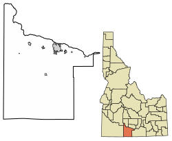
Location of Castleford in Twin Falls County, Idaho.
|
|
| Country | United States |
| State | Idaho |
| County | Twin Falls |
| Area | |
| • Total | 0.10 sq mi (0.25 km2) |
| • Land | 0.10 sq mi (0.25 km2) |
| • Water | 0.00 sq mi (0.00 km2) |
| Elevation | 3,875 ft (1,181 m) |
| Population
(2010)
|
|
| • Total | 226 |
| • Density | 2,604.17/sq mi (1,008.25/km2) |
| Time zone | UTC-7 (Mountain (MST)) |
| • Summer (DST) | UTC-6 (MDT) |
| ZIP code |
83321
|
| Area code(s) | 208, 986 |
| FIPS code | 16-13240 |
| GNIS feature ID | 2409410 |
Castleford is a small city located in Twin Falls County, Idaho, in the United States. In 2010, about 226 people lived there. It is part of the larger Twin Falls, Idaho area.
Contents
Where is Castleford?
Castleford is found on the west side of Salmon Falls Creek. This creek is a natural waterway. The city covers a total area of about 0.09 square miles (0.23 square kilometers). All of this area is land.
What is the climate like?
Castleford has a semi-arid climate. This means it is usually dry. It does not get a lot of rain.
| Climate data for Castleford, Idaho, 1991–2020 normals, extremes 1963–2021 | |||||||||||||
|---|---|---|---|---|---|---|---|---|---|---|---|---|---|
| Month | Jan | Feb | Mar | Apr | May | Jun | Jul | Aug | Sep | Oct | Nov | Dec | Year |
| Record high °F (°C) | 63 (17) |
69 (21) |
80 (27) |
89 (32) |
100 (38) |
103 (39) |
105 (41) |
102 (39) |
96 (36) |
89 (32) |
85 (29) |
64 (18) |
105 (41) |
| Mean maximum °F (°C) | 51.8 (11.0) |
57.2 (14.0) |
69.7 (20.9) |
79.0 (26.1) |
86.3 (30.2) |
93.3 (34.1) |
97.3 (36.3) |
95.3 (35.2) |
90.2 (32.3) |
80.5 (26.9) |
64.7 (18.2) |
52.0 (11.1) |
97.8 (36.6) |
| Mean daily maximum °F (°C) | 36.1 (2.3) |
42.1 (5.6) |
52.9 (11.6) |
60.1 (15.6) |
69.5 (20.8) |
78.4 (25.8) |
87.9 (31.1) |
85.9 (29.9) |
76.3 (24.6) |
62.0 (16.7) |
46.5 (8.1) |
35.3 (1.8) |
61.1 (16.2) |
| Daily mean °F (°C) | 28.2 (−2.1) |
32.6 (0.3) |
40.6 (4.8) |
46.5 (8.1) |
55.0 (12.8) |
62.8 (17.1) |
70.8 (21.6) |
68.9 (20.5) |
60.2 (15.7) |
48.4 (9.1) |
36.0 (2.2) |
27.2 (−2.7) |
48.1 (9.0) |
| Mean daily minimum °F (°C) | 20.3 (−6.5) |
23.1 (−4.9) |
28.3 (−2.1) |
32.9 (0.5) |
40.6 (4.8) |
47.1 (8.4) |
53.8 (12.1) |
51.9 (11.1) |
44.2 (6.8) |
34.8 (1.6) |
25.6 (−3.6) |
19.2 (−7.1) |
35.2 (1.8) |
| Mean minimum °F (°C) | 5.8 (−14.6) |
10.1 (−12.2) |
18.8 (−7.3) |
22.8 (−5.1) |
30.3 (−0.9) |
36.5 (2.5) |
45.3 (7.4) |
42.2 (5.7) |
33.2 (0.7) |
23.0 (−5.0) |
11.4 (−11.4) |
5.3 (−14.8) |
−0.7 (−18.2) |
| Record low °F (°C) | −23 (−31) |
−14 (−26) |
0 (−18) |
12 (−11) |
22 (−6) |
30 (−1) |
34 (1) |
33 (1) |
15 (−9) |
4 (−16) |
−10 (−23) |
−26 (−32) |
−26 (−32) |
| Average precipitation inches (mm) | 1.22 (31) |
1.05 (27) |
0.96 (24) |
1.21 (31) |
1.43 (36) |
0.75 (19) |
0.24 (6.1) |
0.34 (8.6) |
0.50 (13) |
0.78 (20) |
0.94 (24) |
1.30 (33) |
10.72 (272.7) |
| Average snowfall inches (cm) | 4.6 (12) |
2.5 (6.4) |
0.8 (2.0) |
0.2 (0.51) |
0.0 (0.0) |
0.0 (0.0) |
0.0 (0.0) |
0.0 (0.0) |
0.0 (0.0) |
0.2 (0.51) |
2.2 (5.6) |
4.9 (12) |
15.4 (39.02) |
| Average precipitation days (≥ 0.01 in) | 5.7 | 5.7 | 6.5 | 6.0 | 5.8 | 4.5 | 1.7 | 1.5 | 2.2 | 3.6 | 6.3 | 5.7 | 55.2 |
| Average snowy days (≥ 0.1 in) | 2.5 | 1.4 | 0.7 | 0.2 | 0.0 | 0.0 | 0.0 | 0.0 | 0.0 | 0.1 | 1.2 | 2.8 | 8.9 |
| Source 1: NOAA (precip days, snow/snow days 1981–2010) | |||||||||||||
| Source 2: National Weather Service | |||||||||||||
Who lives in Castleford?
| Historical population | |||
|---|---|---|---|
| Census | Pop. | %± | |
| 1960 | 274 | — | |
| 1970 | 174 | −36.5% | |
| 1980 | 191 | 9.8% | |
| 1990 | 179 | −6.3% | |
| 2000 | 277 | 54.7% | |
| 2010 | 226 | −18.4% | |
| 2019 (est.) | 250 | 10.6% | |
| U.S. Decennial Census | |||
Population in 2010
In 2010, the census showed that 226 people lived in Castleford. There were 90 households, which are groups of people living together. About 48 of these were families.
Most people (87.6%) were White. About 35% of the people were Hispanic or Latino.
The average age of people in Castleford was 33.7 years old.
- About 26% of residents were under 18 years old.
- About 12% were 65 years or older.
- The number of males and females was almost equal.
See also

- In Spanish: Castleford (Idaho) para niños
 | Georgia Louise Harris Brown |
 | Julian Abele |
 | Norma Merrick Sklarek |
 | William Sidney Pittman |

