Cathlamet, Washington facts for kids
Quick facts for kids
Cathlamet
|
|
|---|---|
| Cathlamet, Washington | |

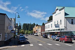
Downtown Cathlamet
|
|

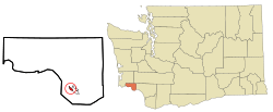
Location of Cathlamet, Washington
|
|
| Country | United States |
| State | Washington |
| County | Wahkiakum |
| Area | |
| • Total | 0.51 sq mi (1.32 km2) |
| • Land | 0.51 sq mi (1.31 km2) |
| • Water | 0.00 sq mi (0.00 km2) 1.46% |
| Elevation | 79 ft (24 m) |
| Population
(2020)
|
|
| • Total | 560 |
| • Density | 1,098/sq mi (424/km2) |
| Time zone | UTC-8 (Pacific (PST)) |
| • Summer (DST) | UTC-7 (PDT) |
| ZIP code |
98612
|
| Area code | 360 |
| FIPS code | 53-10635 |
| GNIS feature ID | 1503862 |
| Website | Town of Cathlamet |
Cathlamet is a small town in Wahkiakum County, Washington. It's located along the Ocean Beach Highway. Cathlamet is also the county seat, which means it's where the main government offices for the county are located. In 2020, about 560 people lived there.
Contents
History of Cathlamet
Long ago, Cathlamet was one of the biggest villages for Native American groups living near the Columbia River. It was home to the Kathlamet people.
In 1792, a British explorer named Lt. W.R. Broughton saw the village. Later, in 1805, famous explorers Lewis and Clark visited. They noted that about 300-400 people lived there in houses made of cedar wood.
The first permanent non-Native settler was James Albion Birnie in 1846. He had worked for the Hudson's Bay Company, a big fur trading business. Birnie set up a trading post in the area. He first called the place "Birnie's Retreat." But in 1851, the name was changed to Cathlamet.
Cathlamet officially became a town on February 18, 1907. Years later, in 1938, the Julia Butler Hansen Bridge was built. This bridge helps people travel across the Columbia River to Puget Island.
Geography and Location
Cathlamet is found in southwestern Washington, right on the Columbia River. It's directly across from Puget Island and the state of Oregon.
You can easily reach the Pacific Ocean to the west or the city of Longview to the east using State Route 4. Another road, State Route 409, takes you to Puget Island. From there, you can take the Wahkiakum County Ferry across the Columbia River to Westport, Oregon.
The town covers about 0.50 square miles (1.3 square kilometers). Most of this area is land, with a very small part being water.
Cathlamet's Climate
| Climate data for Cathlamet, Washington | |||||||||||||
|---|---|---|---|---|---|---|---|---|---|---|---|---|---|
| Month | Jan | Feb | Mar | Apr | May | Jun | Jul | Aug | Sep | Oct | Nov | Dec | Year |
| Mean daily maximum °F (°C) | 45 (7) |
50 (10) |
54 (12) |
59 (15) |
64 (18) |
68 (20) |
74 (23) |
75 (24) |
71 (22) |
62 (17) |
50 (10) |
45 (7) |
60 (15) |
| Mean daily minimum °F (°C) | 31 (−1) |
33 (1) |
35 (2) |
38 (3) |
43 (6) |
47 (8) |
51 (11) |
51 (11) |
46 (8) |
39 (4) |
35 (2) |
32 (0) |
40 (5) |
| Average precipitation inches (mm) | 8.28 (210) |
6.75 (171) |
5.94 (151) |
4.08 (104) |
2.69 (68) |
1.83 (46) |
0.84 (21) |
0.96 (24) |
2.22 (56) |
4.08 (104) |
8.84 (225) |
8.98 (228) |
55.49 (1,408) |
| Source: The Weather Channel | |||||||||||||
Cathlamet has a mild climate. Summers are warm and pleasant, while winters are cool and rainy. The wettest months are usually November and December.
Population Information
| Historical population | |||
|---|---|---|---|
| Census | Pop. | %± | |
| 1880 | 133 | — | |
| 1910 | 362 | — | |
| 1920 | 422 | 16.6% | |
| 1930 | 537 | 27.3% | |
| 1940 | 621 | 15.6% | |
| 1950 | 501 | −19.3% | |
| 1960 | 615 | 22.8% | |
| 1970 | 647 | 5.2% | |
| 1980 | 635 | −1.9% | |
| 1990 | 508 | −20.0% | |
| 2000 | 565 | 11.2% | |
| 2010 | 532 | −5.8% | |
| 2020 | 560 | 5.3% | |
| U.S. Decennial Census | |||
How Many People Live Here?
In 2010, there were 532 people living in Cathlamet. Most residents were White (94.7%). A small number of people were of other backgrounds, including Native American, Asian, African American, or from two or more races. About 3.4% of the population was Hispanic or Latino.
The average age in Cathlamet in 2010 was about 53 years old. About 15% of the people were under 18.
Arts and Culture
Local Festivals and Events
Cathlamet hosts a fun, two-day festival called "Bald Eagle Days." It usually takes place in July. The festival includes a parade, street vendors, and special activities for kids. The town's "Art in the Park" workshop and farmer's market are also part of the event. The first Bald Eagle Days was held in 1982.
Historic Buildings and Places
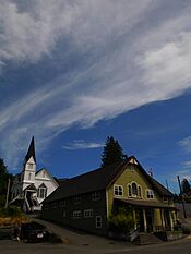
In the center of town, you can find the Pioneer Church. This historic building was built way back in 1895.
Cathlamet in Movies and Books
Cathlamet has been a filming location for several movies:
- Come See the Paradise (1990)
- Snow Falling on Cedars (1999)
- Men of Honor (2000)
Also, the horror novel The Good House by Tananarive Due is set in a fictional town called Sacajawea, WA, which was inspired by Cathlamet.
Education in Cathlamet
Cathlamet is home to all the schools in the Wahkiakum School District. This district serves students from kindergarten all the way through 12th grade (K-12). About 430 students attend these schools. They come from Cathlamet and nearby areas like Puget Island and Skamokawa Valley.
Notable People from Cathlamet
- James Birnie: He was a fur trader and is known as the founder of the town.
- Julia Butler Hansen: A politician who served in the United States House of Representatives from 1960 to 1974.
See also
 In Spanish: Cathlamet (Washington) para niños


