
Cazones de Herrera facts for kids
Quick facts for kids
Cazones
|
||
|---|---|---|
|
Town and Municipality
|
||
| Cazones de Herrera | ||
     Top: Cazones main plaza; Middle: Cazones de Herrera Municipal Hall, Sacred Heart of Jesus Church; Bottom: Cazones Lighthouse, Chaparrales Beach
|
||
|
||
| Etymology: Cazón: sharpnose shark in Mexican Spanish | ||

Cazones
Location in Veracruz

Cazones
Location in Mexico
|
||
| Country | ||
| State | ||
| Municipal Status | 1936 | |
| Area | ||
| • Municipality | 273.1 km2 (105.4 sq mi) | |
| Elevation
(of seat)
|
10 m (30 ft) | |
| Population
(2020) Municipality
|
||
| • Municipality | 24,421 | |
| • Density | 89.4/km2 (232/sq mi) | |
| • Seat | 4,773 | |
| Time zone | UTC-6 (Central (US Central)) | |
| • Summer (DST) | UTC-5 (Central) | |
| Postal code (of seat) |
92977
|
|

| Historical population | ||
|---|---|---|
| Year | Pop. | ±% |
| 1995 | 23,621 | — |
| 2000 | 23,839 | +0.9% |
| 2005 | 23,059 | −3.3% |
| 2010 | 23,483 | +1.8% |
| 2015 | 23,675 | +0.8% |
| 2020 | 24,421 | +3.2% |
Cazones de Herrera, or just Cazones, is a town and municipality in the northern part of the Mexican state of Veracruz. It is located right on the Gulf of Mexico. While it has cool beaches and places for tourists, especially near Barra de Cazones, many people in the area work hard in farming.
Contents
The Town of Cazones
The town of Cazones de Herrera is about 321 kilometers (200 miles) from Xalapa, which is the capital city of Veracruz. It's a small town, much like others in the area. You'll find a main church, a central plaza, a kiosk, and the municipal palace, which is like the town hall.
The town is right next to the Cazones River. You can even take a boat from the town to other communities across the river. Some boats are big enough to carry vehicles! Even though it's the biggest community in the municipality with about 4,773 people (as of 2020), many families here work hard to make a living.
History of Cazones

The name "Cazones" comes from a Spanish word for the Atlantic sharpnose shark. These sharks used to be very common in the waters here. The "de Herrera" part was added to honor a soldier and politician named José Joaquín de Herrera.
The town's official seal shows things important to the area. It has citrus fruits and corn, which are grown there, and of course, sharpnose sharks! Other parts of the seal show the land and Farallón Island, which is at the mouth of the Cazones River.
Long ago, before the Spanish arrived, this area was part of the Totonacapan region. Later, in the 1400s, the Aztecs took control. After the Spanish Conquest, the Totonac people became important in the local culture again.
After Mexico became independent, this area was part of the Papantla municipality. The current municipality of Cazones was created in 1936. It was formed from land that used to belong to Papantla and Tuxpan. The town of Cazones was chosen as its main center. The full official name, Cazones de Herrera, was adopted in 1956.
The Municipality of Cazones

The town of Cazones de Herrera is the main government center for 70 other smaller communities. The whole municipality covers an area of 273.1 square kilometers (about 105 square miles). It shares borders with other municipalities like Tuxpan, Papantla, Poza Rica, and Tihuatlán. To the east, it has the beautiful Gulf of Mexico.
Besides the main town, some other important communities are La Unión (with 1,824 people), Rancho Nuevo (1,238 people), Barra de Cazones (1,166 people), and Manlio Fabio Altamirano (1,121 people). The local government is run by a mayor (called a municipal president), an officer called a "síndico," and four representatives called "regidors."
Geography and Nature
The municipality is usually about ten meters (33 feet) above sea level. The main river is the Cazones River, which divides the municipality into two parts. This river is also a traditional border between two cultural regions: Totonacapan and La Huasteca. Where the river meets the sea, it forms the Barra de Cazones, which is like a sandbar.
The coastline of Cazones faces the Gulf of Mexico and has several beaches. One special beach is Playa Chaparrales, where marine turtles come to lay their eggs in March and April. The weather here is hot and humid, with an average temperature of 25°C (77°F) and a lot of rain. The main type of forest is a tropical rainforest with tall, evergreen trees. You can still find tropical hardwood trees in the remaining forests. Along the shoreline, there are many estuaries with mangrove trees.
Wildlife in the area includes rabbits, raccoons, opossums, armadillos, and coyotes. The mangroves along the river are home to different kinds of crabs, some of which are becoming rare.
Culture and Economy

Today, this area is considered the far southeast part of the La Huasteca cultural region. Traditional dances from this region are popular, and danzón is a very traditional type of music. The municipality often holds events to keep these traditional dances alive.
The creation of the municipality is celebrated every year from June 16 to 23. Carnival is another big annual festival. The local food is famous for its seafood, like shrimp, sea bass, crab, and octopus. These are often served with special sauces like mole, adobo, and chili pepper. A unique dish that isn't seafood is pork served in a chili pepper and garlic sauce.
Most people in Cazones speak Spanish, but about 15% of the population also speaks an indigenous language.
Many people in the municipality work in farming, fishing, and forestry. The main crops grown here are corn, oranges, bananas, green chili peppers, and grapefruit. Farmers also raise livestock like cattle, pigs, sheep, goats, and chickens. Some people work in mining, construction, and utilities. About 32% of the working population is involved in shops and services, including tourism.
Education and Services
The municipality has 32 preschools, one special education facility, 42 primary schools, 16 middle schools, and 9 high schools. There are no universities or higher education facilities here. There are also 17 public libraries. In 2010, about 15% of the people could not read or write, and about 19% had not finished primary school.
Most homes (over 96%) have electricity, and about 58% have running water. About 70% of homes have cement floors. Many homes have televisions (86%), refrigerators (70%), and radios (69%). About 34% have cell phones, but fewer people have computers (about 5%) or internet access (less than 2%).
Sports and Tourism


The National Triathlon of Cazones is a big yearly sports event in northern Veracruz. The money raised from this event helps protect marine turtle homes.
The best tourist spots in the municipality are its beaches and the Cazones River. The most famous area is Barra de Cazones, where almost all the hotels are. This community has a main boardwalk and docks that were built in 2006. The Cazones lighthouse, built in the 1970s, helps guide small fishing boats.
Farallón Island
Farallón is a small island at the mouth of the Cazones River, about half a kilometer from the ocean. Long ago, during colonial times, pirates used it as a hiding spot. One side of the island has an 18-meter-high (59-foot) cliff called "El Chivo," which is popular for rappelling. The island is also home to a type of black iguana called "garrobo negro."
Popular Beaches
- Playa Sur is the most well-known beach because it has hotels and other things for tourists.
- Playa Norte is a natural, untouched beach with no permanent buildings. It's on the opposite side of the river mouth from the main docks. You can find many seagulls here, and parts of the beach are covered in seashells and coral pieces. One cool feature is "El Pulpo" (The Octopus), a rock formation that looks like it has six arms, shaped by ocean waves. Another is the Cueva del Tigre (Tiger Cave), a small cave that gets hidden when the tide is high.
- Playa Chaparrales is a semi-natural beach where buildings are mostly hidden from the shore. This beach has piles of shells washed ashore in interesting shapes. It's a protected place where three types of marine turtles lay their eggs. Visitors can come to the beach during nesting times, and government officials guard the area.
- Playa Azul is another semi-natural beach with an estuary called El Tejón.
- Playa Boquillas gets its name from the Boquillas River estuary.
Other Natural Spots

- Arrecife Blake (Blake Reef) is also called "Bajo Negro" (Black Low) because it has black coral. It also has large areas of mangroves.
- La Encantada is a cave that is home to a small type of bat.
The municipality has about 71.1 kilometers (44 miles) of highways, mostly maintained by the state government.
Images for kids
-
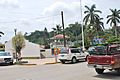
Cazones main plaza
-
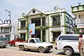
Cazones de Herrera Municipal Hall
-
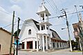
Sacred Heart of Jesus Church
-
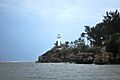
Cazones Lighthouse
-
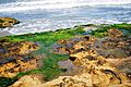
Chaparrales Beach
-
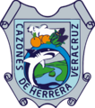
Seal of Cazones de Herrera
See also
 In Spanish: Municipio de Cazones de Herrera para niños
