
Cedar River (Gladwin County, Michigan) facts for kids
Quick facts for kids Cedar River |
|
|---|---|

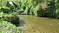
The Cedar River in Gladwin
|
|
| Country | United States |
| Physical characteristics | |
| Main source | Hamilton Township, Clare County |
| River mouth | Tobacco River 712 ft (217 m) |
| Basin features | |
| River system | Saginaw River |
The Cedar River is a river in the United States state of Michigan. It flows for about 29.0-mile-long (46.7 km), which is like driving from one end of a medium-sized town to another. This river runs through Clare County and Gladwin County.
The main part of the Cedar River starts when two smaller streams, Cranberry Creek and the West Branch Cedar River, join together. This happens in Hamilton Township, in Clare County. The river then flows into the Tobacco River near Beaverton.
Contents
Branches of the Cedar River
The Cedar River has several important branches that feed into it. These branches help make the river bigger and stronger as it flows.
North Branch Cedar River
The North Branch Cedar River begins in the northwest part of Gladwin County. It starts in Sherman Township, close to the border with Roscommon County. This branch then flows until it meets the main Cedar River a few miles northwest of Wiggins Lake.
Middle Branch Cedar River
The Middle Branch Cedar River starts in the northeast part of Clare County. It begins in Franklin Township. This branch mostly flows south before joining the West Branch Cedar River in Hamilton Township, near the edge of Gladwin County.
West Branch Cedar River
The West Branch Cedar River also starts in Franklin Township, a few miles southwest of Meredith. Another stream, Cranberry Creek, starts from Arnold and Cranberry lakes. These lakes are a few miles northeast of Harrison.
It's interesting to know that the Little Cedar River is not part of the Cedar River system. It flows into the Tobacco River about 5 miles (8 km) downstream from Beaverton.
What Flows into the Cedar River?
Many smaller streams, lakes, and drains flow into the Cedar River. These are called tributaries. They add water to the river as it travels.
Here are some of the places that connect to the Cedar River, starting from its mouth and moving upstream:
- Doone Creek
- Farm Drain
- Canham Drain
- Lucas Drain
- Swan Lake (also known as Slaughterhouse Lake)
- The City of Gladwin is located along the river.
- Bendle Drain
- Silver Creek
- Chappel Dam, which helps create Wiggins Lake.
- Wiggins Lake (also known as Chappel Pond)
- Howland Creek, which flows from Howland Lake.
- Frost Lake
- Smith Creek
- Lake Contos
- Puro Lake
- Mud Lake, which connects to Pratt Lake.
- North Branch Cedar River
- Peach Lake
- McGilvery Lake
- Schoolhouse Lake
- Greasy Jim Lake
- Blue Lake, which connects to Island Lake.
- Streaked Lake, which connects to Trout Lake (Gladwin County). Trout Lake then connects to House Lake and Hoister Lake.
- Middle Branch Cedar River
- Lindy Lake
- Lake Little George
- Trout Lake (Clare County)
- Decker Lake
- West Branch Cedar River
- Popple Creek
- Cranberry Creek, which flows from Cranberry Lake and Arnold Lake.
Where Does the River Get Its Water?
The Cedar River gets its water from a large area called a drainage basin. This basin includes parts of two counties in Michigan:
Clare County Areas
- Arthur Township
- Franklin Township
- Frost Township
- Hamilton Township
- Hayes Township
Gladwin County Areas
- City of Beaverton
- Beaverton Township
- Buckeye Township
- City of Gladwin
- Gladwin Township
- Grout Township
- Sage Township
- Sherman Township
- Tobacco Township
Images for kids
-
The creek flowing through downtown Gladwin
.jpg)
