
Cedars of Lebanon State Park facts for kids
Quick facts for kids Cedars of Lebanon State Park |
|
|---|---|

cedar glade
|
|
| Type | Tennessee State Park |
| Location | Lebanon, Tennessee |
| Area | 900 acres (364 ha) |
| Operated by | Tennessee Department of Environment and Conservation |
| Website | Cedars of Lebanon State Park |
|
Cedars of Lebanon State Park Historic District
|
|

Cedar Lodge
|
|
| Nearest city | Lebanon, Tennessee |
| Built | 1925-1949 |
| NRHP reference No. | 95001274 |
| Added to NRHP | 1995 |
Cedars of Lebanon State Park is a special place in Wilson County, Tennessee. It covers about 900 acres (364 hectares). This park is part of a much larger area called the Cedars of Lebanon State Forest, which is about 9,420 acres (3,812 hectares). Both the park and the forest are located about 10 miles (16 km) south of the city of Lebanon, Tennessee.
The Cedars of Lebanon State Forest is famous for its unique areas called cedar glades. These are special ecosystems where the soil is very thin, or sometimes there's no soil at all! Because of this, only certain plants can grow there. You'll often see thick groups of red cedar trees around these glades. These trees are a type of juniper that can survive in very thin soil. Early settlers thought these red cedar trees looked like the famous cedar forests from the Bible. That's how the park got its name!
Where is the Park?
Cedars of Lebanon State Park is located in a flat area of Middle Tennessee. It's about 15 miles (24 km) west of the Highland Rim and 15 miles (24 km) east of Nashville. The park is also about 20 miles (32 km) north of Murfreesboro. A main road, U.S. Route 231, goes right through the state forest. The developed part of the park is on the eastern side of this road. The western part is mostly undeveloped forest.
The park area has many underground streams. This is common in places with karst geology, where water flows through cracks in the rock. The water from the forest eventually flows into nearby streams like Hurricane Creek. These streams then lead to J. Percy Priest Lake, which is a few miles west of the park.
Amazing Nature

The ground beneath Cedars of Lebanon State Forest is made of limestone. This rock formed about 460 million years ago from tiny bits of shells and sea creatures in an ancient ocean. Over time, water has worn away this rock, creating cool features like sinkholes, underground caves, and cracks in the ground. You can see these everywhere in the park and forest. The soil here is often very thin, and sometimes the limestone rock is right on the surface.
The cedar glades are special because their plants have learned to live in these tough conditions. The soil is too thin for most big trees. Glades often look like rocky or gravelly meadows. Some spots have bare rock where nothing grows. Other areas have gravel where only grasses can grow. Then there are patches of very thin soil that support small shrubs and red cedars. These glades are usually surrounded by thick groups of red cedar trees. Beyond these cedar thickets, the soil gets thicker, allowing bigger trees like oak and hickory to grow.
The cedar glades at Cedars of Lebanon State Forest are home to 350 different kinds of plants. Twenty-nine of these plants are found only in cedar glades! Some of the cool flowering plants you might see include the Tennessee Coneflower, the Prickly Pear cactus, and the Limestone flame flower (Phemeranthus calcaricus). You might also spot Gattinger's Prairie Clover (Dalea gattingeri) and Glade Phlox (Phlox bifida). Besides red cedars, the surrounding forest has white oak and shagbark hickory trees. You'll mostly see small animals like rodents and different kinds of birds here.
Park History
The first European settlers came to Wilson County in the late 1790s. The city of Lebanon was founded in 1802. It was named "Lebanon" because there were so many red cedar trees. The settlers thought these trees looked like the famous cedar forests of ancient Lebanon. Those ancient cedars were used to build important structures like the Temple of Solomon. Early buildings in Wilson County, including the first courthouse, were also made from red cedar logs.
For a long time, the glades were mostly empty, except for a few small farms. The soil was known to be very thin and dry. In the late 1800s and early 1900s, there was a high demand for wood. Red cedar was popular for furniture, fences, and pencils. Farmers in the cedar glades struggled because their thin soil was getting even worse from poor farming methods.
In 1935, during a time called the New Deal, the government started a plan to help farmers move from worn-out lands. This allowed the forests to grow back. As part of the "Lebanon Cedar Forest Project," the government helped farmers move. Workers from the Works Project Administration (WPA) built park facilities and planted thousands of red cedar trees. The "Lebanon Cedar Forest" officially opened in 1937. The federal government owned the land until 1955, when it was given to the state of Tennessee.
Scientists realized how important the cedar glades were a long time ago. In 1973, the forest was named a National Natural Landmark. This means it's a very special natural area. In 1995, Cedar Lodge and other buildings built by the WPA in the 1930s and 1940s were added to the National Register of Historic Places. This protects them as important historical sites.
What to Do Today

Cedars of Lebanon State Park is a great place to visit! It has 117 campsites where you can stay overnight. There are also 11 picnic shelters for day trips. If you love hiking, there are 8 miles (13 km) of trails. The park also has a group lodge and a meeting hall. You can learn more about the forest's nature at the Merritt Nature Center, which has a small museum. The park even has a disc golf course for some fun.
The park's hiking trails are different lengths, from 0.5 miles (0.8 km) to 5 miles (8 km).
- The 0.5-mile (0.8 km) Cedar Glades Trail starts at the visitor center. It's a self-guided trail that takes you through different cedar glade habitats.
- The 2-mile (3.2 km) Cedar Forest Trail loops through a forest with oak, hickory, and red cedar trees. You'll see some big sinkholes along this trail.
- The 0.5-mile (0.8 km) Dixon Merritt Trail starts behind the Merritt Nature Center. This trail leads to Jackson Cave.
- The 0.5-mile (0.8 km) Limestone Sinks Trail is another self-guided trail that passes several large limestone sinks.
- The 5-mile (8 km) Hidden Springs Trail is the longest. It starts near the picnic area and takes you through many different parts of the forest. You'll see a big limestone sink, dry streambeds, several cedar glades, and thick forests.
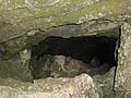
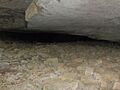
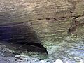
Jackson Cave is one of 18 known caves in the area. The entrance to the cave is 30 feet (9 m) wide and 4 feet (1.2 m) high. Inside, the cave is usually about 12 feet (3.7 m) wide and 6 feet (1.8 m) high. The cave goes about 1,000 feet (300 m) until it reaches a large pool of water.
Images for kids
-
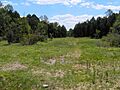
Cedar glade along Hidden Springs Trail
-
Sinkhole along the Cedar Forest Trail
-
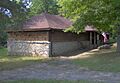
Merritt Nature Center
-
Entrance to Jackson Cave
-
The wall of a large sinkhole along the Hidden Springs Trail
-
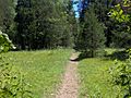
Hidden Springs Trail crossing a cedar glade
-
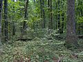
Oak-hickory forest along Hidden Springs Trail
-
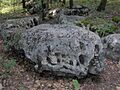
Blockfield along the Cedar Forest Trail


