Cefn Eglwysilan facts for kids
Quick facts for kids Cefn Eglwysilan |
|
|---|---|

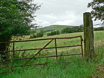
View towards Cefn Eglwysilan
|
|
| Highest point | |
| Elevation | 382 m (1,253 ft) |
| Prominence | 235 m (771 ft) |
| Listing | Marilyn |
| Naming | |
| English translation | back (ridge) of Ilan’s church |
| Language of name | Welsh |
| Geography | |
| Location | Caerphilly/Rhondda Cynon Taf, Wales |
| OS grid | ST 097905 |
| Topo map | OS Landranger 171 / Explorer 166 |
Cefn Eglwysilan is a cool hill located in South Wales. It has two peaks, both about 382 meters (1,253 feet) high. These peaks are found about 2 kilometers east of Pontypridd, in the Rhondda Cynon Taf area. Part of its eastern side is in the Aber Valley, which is in the Caerphilly area.
The hill gets its name from a nearby small village called Eglwysilan. The church there is named after a saint called Ilan. You'll find a wireless transmission station on the northern peak. The southern peak has a 'trig point,' which is a special marker used for surveying.
Contents
What is Cefn Eglwysilan Made Of?
Cefn Eglwysilan is made mostly of a type of rock called Hughes Sandstone. This rock formed a very long time ago, about 306 to 309 million years ago. This was during the Carboniferous Period, when Earth looked very different! Below the main sandstone, you can also find layers of siltstone and mudstone.
Ancient History of the Hill
The hill has some interesting old features from long ago.
The Senghenydd Dyke
A long earthwork called Senghenydd Dyke stretches across the eastern side of the hill. An earthwork is like a ditch or a bank made by people a long time ago. Experts believe this dyke marked the edge of a huge deer park from the 13th century. This park was connected to the famous Caerphilly Castle nearby.
Other Earthworks and Cairns
There are also three smaller earthworks on the flat top of the hill. More earthworks can be seen on its southern side. You can find a pile of stones called Garnedd Lwyd next to the main dyke. There are also other stone piles, known as Garneddi Llwydion, in another spot near the Senghenydd Dyke. These stone piles are called cairns.
Exploring Cefn Eglwysilan
The top part of Cefn Eglwysilan is mapped as "open access." This means anyone can freely walk and explore there!
Paths and Trails
There are also a couple of special paths called "byways" that cross the hill. These byways connect a smaller road, Eglwysilan Road, with the main road between Nelson and Senghenydd. The Rhymney Valley Ridgeway Walk, a popular walking trail, follows one of these byways along the eastern edge of the hill's top.

