
Central Northside (Pittsburgh) facts for kids
Quick facts for kids
Central Northside
|
|
|---|---|
|
Neighborhood of Pittsburgh
|
|
 |
|
 |
|
| Country | United States |
| State | Pennsylvania |
| County | Allegheny County |
| City | Pittsburgh |
| Area | |
| • Total | 0.259 sq mi (0.67 km2) |
| Population
(2010)
|
|
| • Total | 2,923 |
| • Density | 11,286/sq mi (4,357/km2) |
Central Northside is a cool neighborhood located in the North Side part of Pittsburgh, Pennsylvania. It's known for its beautiful, old-fashioned row houses that have been fixed up. You'll also find lots of community gardens and streets lined with trees.
This area was once called "The Buena Vista Tract." It has a special postal code, 15212. A local leader, called a council member, represents the neighborhood in the Pittsburgh City Council. This council member helps make decisions for the city.
Contents
Exploring Central Northside's Past
Central Northside has a rich history, especially from the late 1800s. Back then, the area was part of a separate city called Allegheny, Pennsylvania. Wealthy families built grand homes here. This part of Allegheny later became a neighborhood in Pittsburgh.
What Are the Mexican War Streets?
One famous part of Central Northside is called the Mexican War Streets. These streets were planned in 1847 by William Robinson Jr.. He was a former mayor of Allegheny.
Robinson named the streets after important battles and generals from the Mexican–American War. You can find streets like Buena Vista Street, Monterey Street, Palo Alto Street, and Taylor Avenue. Even though he named them, Robinson himself didn't fight in the war.
Discovering City Steps in Central Northside
Central Northside is home to four unique sets of city steps. These steps are like outdoor staircases. They help people walk easily through the hilly neighborhood.
The city steps connect residents to public transportation. They also provide quick routes to local schools. For example, the O'Hern Street steps lead right to the Propel Northside charter school.

Neighborhoods Around Central Northside
Central Northside shares its borders with seven other Pittsburgh neighborhoods. Knowing these helps you understand where Central Northside is located.
- To the north, you'll find Perry South.
- Fineview is to the northeast.
- To the southeast is East Allegheny.
- Allegheny Center is to the south.
- To the southwest, there's Allegheny West.
- Manchester is to the west.
- And California-Kirkbride is to the northwest.
Central Northside in Movies
This neighborhood has even appeared in movies! Its unique look has made it a setting for fictional stories.
- In 1979, the movie The Fish That Saved Pittsburgh used North Avenue. This street was once known for its entertainment venues. The film showed a character's office and home near the Garden Theater.
- Years later, in 2010, the movie One for the Money used the same buildings. The Garden Theater marquee was featured again. This showed how the area could still look like a busy city environment, even after many changes.
What's in a Name?
In 2012, the Central Northside Neighborhood Council (CNNC) voted to change the neighborhood's name. They wanted to call it Allegheny City Central.
However, changing official city maps is difficult. The city planning department usually prefers to keep established names. The name change was part of a plan to create a "new brand and marketing strategy" for the area.
Images for kids
-
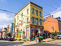
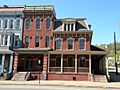
Randyland Art Museum at 1501 Arch Street.
-
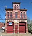
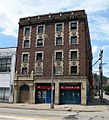
Engine Company No. 3, built in 1877, at 1416 Arch Street.
-
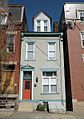
Ferris House (the former home of George Washington Gale Ferris Jr.), likely built in the mid-to-late 19th century, at 1318 Arch Street.
-
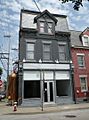
House at 200 West North Avenue, built circa 1880.
-
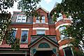
Aberlie House, likely built in the late 19th century, at 122-124 East North Avenue.
-
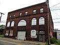
Allegheny City Stables, built in 1895 and 1896, at 836 West North Avenue.
-
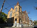
Brown Chapel A.M.E. Church, built in 1903, at 1400 Boyle Street.
-
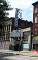
Garden Theater, built in 1915, at 12 West North Avenue.
-
Malta Temple (Salvation Army Building), built in 1927, at 100 West North Avenue.
-
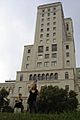
Allegheny General Hospital, built from 1928 to 1930.
-
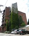
The Mattress Factory art museum at 500 Sampsonia Way.
-
The Mattress Factory's annex gallery building at 1414 Monterey Street (at the corner of Monterey and Jacksonia streets).
-
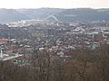
View of the neighborhood from the Fineview Overlook.


