
Chandalar River facts for kids
Quick facts for kids Chandalar River |
|
|---|---|

East Fork of the Chandalar River, at Arctic Village
|
|

Location of the mouth of the Chandalar River in Alaska
|
|
| Native name | T'eedrinjik |
| Country | United States |
| State | Alaska |
| Census Area | Yukon–Koyukuk |
| Physical characteristics | |
| Main source | confluence of the river's north and middle forks southeastern Brooks Range, 23 miles (37 km) south-southeast of Chandalar 1,203 ft (367 m) 67°10′13″N 148°17′50″W / 67.17028°N 148.29722°W |
| River mouth | Yukon River 20 miles (32 km) northwest of Fort Yukon, Yukon Flats National Wildlife Refuge 387 ft (118 m) 66°36′33″N 146°00′09″W / 66.60917°N 146.00250°W |
| Length | 100 mi (160 km) |
| Basin features | |
| Basin size | 9,330 sq mi (24,200 km2) |
The Chandalar River (T'eedriinjik in Gwich'in) is a river in Alaska, a state in the United States. It is about 100-mile (160 km) long. The river flows into the larger Yukon River.
The main part of the Chandalar River starts where two other rivers meet. These are the North Fork Chandalar River and the Middle Fork Chandalar River. From there, it flows mostly southeast through northern Alaska. It passes by the Philip Smith Mountains in the Brooks Range. The Chandalar River joins the Yukon River about 20 miles (32 km) northwest of Fort Yukon.
Scientists measured the river's flow between 1964 and 1974. The highest flow recorded was 62,800 cubic feet per second (1,780 m3/s) on June 9, 1968. This measurement was taken near Venetie.
Contents
Chandalar River's Main Branches
The Chandalar River system has several important branches, also called tributaries. These branches feed water into the main river.
North Fork Chandalar River
The North Fork Chandalar River is about 104 miles (167 km) long. It starts near Atigun Pass in the Brooks Range. It flows southeast and passes through Chandalar Lake. This branch then meets the Middle Fork to form the main Chandalar River. Near its start, there is a flat area called Chandalar shelf. Caribou often spend the winter here.
Middle Fork Chandalar River
The Middle Fork Chandalar River is about 102-mile (164 km) long. It begins in the Philip Smith Mountains, which are east of Atigun Pass. This branch flows south from the mountains until it joins the North Fork.
East Fork Chandalar River
The East Fork Chandalar River is the longest branch, at about 175 miles (282 km) long. It starts near the Romanzof Mountains in the eastern Brooks Range. It flows southwest past Arctic Village. This branch then joins the main Chandalar River before it reaches Venetie.
West Fork Chandalar River
The West Fork Chandalar River is a shorter branch, about 24-mile (39 km) long. It flows east from the mountains near Coldfoot. It joins the North Fork Chandalar River about 5 miles (8 km) upstream from where the North Fork meets the Middle Fork.
Fun Activities on the River
The Chandalar River basin is a great place for outdoor activities like fishing and hunting.
Fishing Opportunities
You can fish in the lower part of the river for fish like northern pike, sheefish, and salmon. However, the upper river, its branches, and nearby lakes offer even more exciting fishing. The main types of fish you can catch here are northern pike, Arctic grayling, charr, and lake trout.
Exploring the Area
Most people who visit this area for fishing or hunting arrive by small airplane. In winter, some use snowmobiles. If you are an experienced boater, you can float down the river system in rafts or kayaks. But be careful, as there can be shallow spots and fast-moving water (rapids). There are no public campsites or facilities along the river. However, there is a fishing lodge located at Chandalar Lake.
Images for kids
-
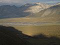
Sunrise over the East Fork of the Chandalar River, in the Brooks Range
-
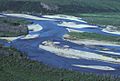
Chandalar River in summer
-
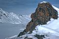
Chandalar River in winter
-
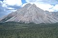
Mountain in the Chandalar River Valley


