Chappaquiddick Island facts for kids
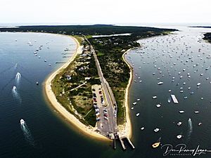
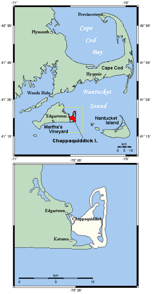
Chappaquiddick Island is a small piece of land near Martha's Vineyard in Massachusetts. People sometimes call it "Chappy." It's part of the town of Edgartown, Massachusetts. Even though it's often connected to Martha's Vineyard by a thin strip of sand called Norton Point, it's still known as an island.
Sometimes, big storms like hurricanes can break this sandy connection, making Chappaquiddick a true island for a while. For example, it was separated from Martha's Vineyard for eight years, from 2007 to 2015.
Visitors enjoy Chappaquiddick because it's quiet and peaceful. They come for its beautiful beaches, to ride bikes, go hiking, and watch birds. There's also a special place called MyToi Gardens, which is a small Japanese garden hidden among the local plants. The island has paved roads, Chappaquiddick Road and Poucha Road, which lead to sandy paths, trails, and shorelines.
Contents
What's in a Name?
The name Chappaquiddick comes from an old Native American word, "cheppiaquidne." This word means "separated island," which makes sense because the island is often separated from Martha's Vineyard by a narrow channel of water. You might also see the name spelled as "Chaubaqueduck" or "Chappaquidgick" in old writings.
Who Lived Here First?
For a long time, Chappaquiddick Island was mainly home to the Chappaquiddick group of the Wampanoag people. They lived there well into the 1800s. Today, they still have a special area of about 100 acres (40 hectares) of brush land in the middle of the island, which is their reservation.
European settlers first came to Edgartown in 1642. They soon claimed Chappaquiddick as part of their village. The first homes built by people of European descent on the island appeared around 1750. These early residents raised animals and farmed the land.
Exploring Chappaquiddick's Nature
A group called The Trustees of Reservations helps protect nearly 1,000 acres (400 hectares) of land on Chappaquiddick. This protected area stretches from Wasque, at the southern tip, all the way to Cape Poge, in the northeast.
Fishing and Lighthouses
Wasque is a popular spot for fishing, where people can catch fish like bluefish and striped bass. At Cape Poge, you'll find the Cape Poge Lighthouse. This lighthouse was first built in 1801 and helps guide ships safely through the shallow waters nearby.
Island Habitats
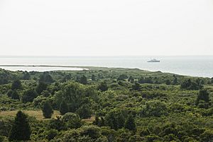
Chappaquiddick is known for its many different natural environments. It has large salt marshes, ponds, woods filled with red cedar trees, and grassy fields. You can also find lots of coastal wildlife here, such as sandpipers, piping plovers, blue herons, osprey, and oysters.
The main bodies of water inside the island are Cape Poge Bay, Katama Bay, and Pocha Pond. All of these are salty.
Changing Coastlines
The island's coast has always changed over time because of ocean currents, storm waves, and tides. However, in recent years, erosion has become a bigger problem. Wasque Point, in particular, was hit hard during a big storm in 2007. Between 2007 and 2013, about 40 acres (16 hectares) of land were lost at Wasque. The strong currents wore away cliffs, caused a pond to disappear, damaged trails along the shore, and even threatened a house.
Chappaquiddick is located at coordinates 41°22′34″N 70°28′33″W. It covers about 6.145 square miles (15.915 square kilometers) of land. It is part of the town of Edgartown and Dukes County.
Who Lives on Chappaquiddick?
In 2010, there were 179 people living on Chappaquiddick Island. Most of the people were White (93.30%), with smaller numbers of African American, Native American, Asian, and people of two or more races. About 2.23% of the population was Hispanic or Latino.
People who live on Chappaquiddick often feel like they are a separate community from the rest of Edgartown. Long-time residents might say they are "going to the mainland" when they travel to Edgartown. If they travel to places like Boston or Cape Cod, they might even say they are "going to America"!
How to Get There
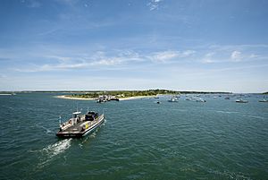
To get to Chappaquiddick, you can take a special ferry. These small, flat boats are called the On Time II and On Time III. They carry people, bikes, and up to three cars at a time between Chappaquiddick and Edgartown. During the summer, two ferries run, but only one runs during the rest of the year. If the islands are connected by the sand strip and conditions are good, you can also drive a four-wheel-drive vehicle along the south shore.
Images for kids
 | Frances Mary Albrier |
 | Whitney Young |
 | Muhammad Ali |


