Charleston, Nevada facts for kids
Quick facts for kids
Charleston, Nevada
|
|
|---|---|
 |
|
| Country | United States |
| State | Nevada |
| County | Elko |
| Elevation | 6,076 ft (1,852 m) |
| Time zone | UTC-8 (Pacific (PST)) |
| • Summer (DST) | UTC-7 (PDT) |
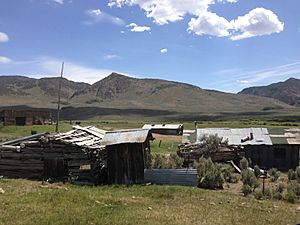
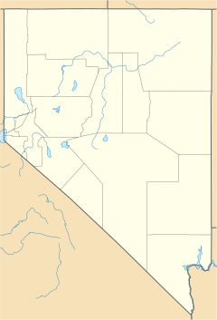
Charleston is a ghost town in Elko County, Nevada, United States. A ghost town is a place where people used to live and work, but now very few or no one lives there. Charleston is located along the Bruneau River. It is just south of the Mountain City and Jarbidge Ranger Districts. These areas are part of the Humboldt-Toiyabe National Forest. The town is also near the southwest edge of the Jarbidge Wilderness, a protected natural area.
History of Charleston
Gold Rush Days
The settlement of Charleston began in 1876. This was when people found gold in a place called Seventy-Six Creek. This creek was at the base of Copper Mountain. At first, the camp was called Mardis. But soon, it was named Charleston after a local gold seeker, Tom Charles.
The town grew very quickly. People built a hotel, saloons, schools, and stores. There was even an icehouse. However, by 1884, most of the gold mining had slowed down or stopped.
Later Years and Decline
A post office was opened in Charleston in 1895. It stayed open for many years, until 1951.
The town saw a comeback in 1905. This was when the local mines started producing gold again. A special machine called a five-stamp mill was built to help process the gold. The mines had another short period of activity from 1932 to 1937. Today, the mines are no longer used. The only two buildings left from the old settlement are on private land.
Climate in Charleston
Charleston has a specific type of weather. It has a humid continental climate. This means it has warm to hot summers and cold winters. It is also very close to a subarctic climate. This type of climate has very cold and long winters.
There is a weather station about 1 mile (1.6 km) north of Charleston. It is located at an elevation of 5,968 feet (1,819 meters). This station helps scientists track the weather patterns.
| Climate data for Charleston Jarbidge 17 SSW, Nevada, 2003–2014 normals, 1961–2017 extremes: 5968ft (1819m) | |||||||||||||
|---|---|---|---|---|---|---|---|---|---|---|---|---|---|
| Month | Jan | Feb | Mar | Apr | May | Jun | Jul | Aug | Sep | Oct | Nov | Dec | Year |
| Record high °F (°C) | 56 (13) |
62 (17) |
72 (22) |
80 (27) |
89 (32) |
98 (37) |
103 (39) |
98 (37) |
92 (33) |
87 (31) |
72 (22) |
58 (14) |
103 (39) |
| Mean maximum °F (°C) | 43.9 (6.6) |
48.5 (9.2) |
60.5 (15.8) |
71.0 (21.7) |
79.6 (26.4) |
86.8 (30.4) |
94.8 (34.9) |
92.0 (33.3) |
87.0 (30.6) |
77.8 (25.4) |
64.6 (18.1) |
50.2 (10.1) |
95.2 (35.1) |
| Mean daily maximum °F (°C) | 33.7 (0.9) |
36.5 (2.5) |
45.3 (7.4) |
53.7 (12.1) |
63.4 (17.4) |
73.1 (22.8) |
86.8 (30.4) |
83.5 (28.6) |
75.4 (24.1) |
61.3 (16.3) |
47.2 (8.4) |
36.0 (2.2) |
58.0 (14.4) |
| Daily mean °F (°C) | 17.4 (−8.1) |
21.3 (−5.9) |
30.8 (−0.7) |
38.3 (3.5) |
45.4 (7.4) |
52.4 (11.3) |
62.1 (16.7) |
59.0 (15.0) |
50.5 (10.3) |
40.4 (4.7) |
31.0 (−0.6) |
20.9 (−6.2) |
39.1 (4.0) |
| Mean daily minimum °F (°C) | 1.1 (−17.2) |
6.1 (−14.4) |
16.2 (−8.8) |
22.9 (−5.1) |
27.6 (−2.4) |
31.5 (−0.3) |
37.5 (3.1) |
34.4 (1.3) |
25.8 (−3.4) |
19.5 (−6.9) |
15.2 (−9.3) |
5.4 (−14.8) |
20.3 (−6.5) |
| Mean minimum °F (°C) | −21.9 (−29.9) |
−16.8 (−27.1) |
−2.8 (−19.3) |
9.1 (−12.7) |
14.6 (−9.7) |
22.4 (−5.3) |
27.3 (−2.6) |
23.8 (−4.6) |
14.0 (−10.0) |
6.3 (−14.3) |
−6.6 (−21.4) |
−16.3 (−26.8) |
−26.5 (−32.5) |
| Record low °F (°C) | −39 (−39) |
−39 (−39) |
−28 (−33) |
−2 (−19) |
6 (−14) |
15 (−9) |
20 (−7) |
15 (−9) |
5 (−15) |
−2 (−19) |
−32 (−36) |
−42 (−41) |
−42 (−41) |
| Average precipitation inches (mm) | 0.69 (18) |
0.35 (8.9) |
0.58 (15) |
0.92 (23) |
1.25 (32) |
0.78 (20) |
0.43 (11) |
0.78 (20) |
0.48 (12) |
0.91 (23) |
0.84 (21) |
1.11 (28) |
9.12 (231.9) |
| Average snowfall inches (cm) | 14.1 (36) |
6.4 (16) |
5.0 (13) |
3.3 (8.4) |
0.3 (0.76) |
trace | 0.0 (0.0) |
trace | 0.2 (0.51) |
0.5 (1.3) |
3.6 (9.1) |
13.8 (35) |
47.2 (120.07) |
| Source: XMACIS2 | |||||||||||||
 | Calvin Brent |
 | Walter T. Bailey |
 | Martha Cassell Thompson |
 | Alberta Jeannette Cassell |


