Charlton, Queensland facts for kids
Quick facts for kids CharltonQueensland |
|||||||||||||||
|---|---|---|---|---|---|---|---|---|---|---|---|---|---|---|---|

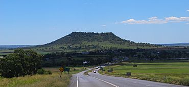
Looking west along the Warrego Highway in Charlton towards Gowrie Mountain, 2015
|
|||||||||||||||
| Population | 107 (2021 census) | ||||||||||||||
| • Density | 7.93/km2 (20.5/sq mi) | ||||||||||||||
| Postcode(s) | 4350 | ||||||||||||||
| Area | 13.5 km2 (5.2 sq mi) | ||||||||||||||
| Time zone | AEST (UTC+10:00) | ||||||||||||||
| Location |
|
||||||||||||||
| LGA(s) | Toowoomba Region | ||||||||||||||
| State electorate(s) | Condamine | ||||||||||||||
| Federal Division(s) | Groom | ||||||||||||||
|
|||||||||||||||
Charlton is a small rural area in Queensland, Australia. It's part of the Toowoomba Region. You can find it about 13 kilometers (8 miles) west of the Toowoomba city center. The main road, the Warrego Highway, runs right through it. In 2021, only 107 people lived in Charlton.
Contents
What is Charlton Like?
Charlton is a quiet place with a mix of natural features and important roads.
Land and Mountains
The Western railway line forms the northern edge of Charlton. A small creek called Dry Creek marks its southern border. Part of Gowrie Mountain is located here. The highest point of this mountain, at 674 meters (2,211 feet) above sea level, is in Charlton.
Roads and Highways
The Warrego Highway is a major road that goes through Charlton. This area is important for how traffic moves around Toowoomba.
- To the northeast, the Warrego Highway is now part of the Toowoomba Bypass. This is a newer road that helps cars go around the city.
- To the east, the old Warrego Highway is now called the Toowoomba Connection Road.
- To the southwest, you'll find a new part of the Gore Highway, which is also part of the Toowoomba Bypass.
- To the northwest, the Warrego Highway continues as it always has.
Charlton's Past
Charlton has a bit of history, especially when it comes to its school.
The Old School
A school first opened in Charlton on July 4, 1898. It was originally called Gowrie Estate Provisional School. Later, in 1909, it became Gowrie Estate State School. In November 1915, its name changed to Charlton State School. It was located on the Warrego Highway.
In 2010, the school had 40 students. They were taught in two classes: one for younger kids (Prep to Year 3) and one for older kids (Years 4 to 7). The school closed its doors on December 31, 2013.
Who Lives in Charlton?
The number of people living in Charlton has changed a little over the years.
- In 2016, there were 120 people living in Charlton.
- By 2021, the population was 107 people.
Learning in Charlton
Today, there are no schools directly in Charlton. Kids living here go to schools in nearby towns.
Nearby Schools
- For primary school, students can go to Kingsthorpe State School (to the northwest), Gowrie Junction State School (to the northeast), Fairview Heights State School (to the southeast), or Wellcamp State School (to the south).
- For high school, the closest government school is Wilsonton State High School, located to the east.
 | Sharif Bey |
 | Hale Woodruff |
 | Richmond Barthé |
 | Purvis Young |


