Kingsthorpe, Queensland facts for kids
Quick facts for kids KingsthorpeQueensland |
|||||||||||||||
|---|---|---|---|---|---|---|---|---|---|---|---|---|---|---|---|

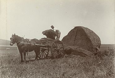
Loading hay onto the wagon, Kingsthorpe District, cira 1902
|
|||||||||||||||
| Population | 2,159 (2021 census) | ||||||||||||||
| • Density | 45.45/km2 (117.7/sq mi) | ||||||||||||||
| Postcode(s) | 4400 | ||||||||||||||
| Area | 47.5 km2 (18.3 sq mi) | ||||||||||||||
| Time zone | AEST (UTC+10:00) | ||||||||||||||
| Location |
|
||||||||||||||
| LGA(s) | Toowoomba Region | ||||||||||||||
| State electorate(s) | Condamine | ||||||||||||||
| Federal Division(s) | Groom | ||||||||||||||
|
|||||||||||||||
Kingsthorpe is a small town and area in the Toowoomba Region of Queensland, Australia. It's a rural place, meaning it's mostly countryside with farms. In 2021, about 2,159 people lived in Kingsthorpe.
Contents
Where is Kingsthorpe?
Kingsthorpe is located on the Darling Downs, a beautiful farming area in Queensland. It's about 21.4 kilometers (13 miles) north-west of the main part of Toowoomba. If you travel further, it's about 144 kilometers (89 miles) west of Brisbane, the capital city of Queensland.
The town has a railway station on the Western railway line. This line helps connect Kingsthorpe to other places. There was also an older station called Kings railway station nearby, but it is now closed.
Kingsthorpe's Story
How Kingsthorpe Got its Name
Kingsthorpe was named after two brothers, Colonel Henry Venn King and George Beresford King. They were pastoralists, which means they owned large areas of land for raising animals like sheep or cattle. Their property was called Gowrie.
Old Churches and Schools
An old church called St Gregory's Anglican Church was first built in Meringandan in 1886. It was later moved to Kingsthorpe in 1905. It was used for many years before it closed around 1982.
Gowrie Mountain Provisional School opened in 1901. It became a State School in 1909 but closed its doors in 1967.
The current Kingsthorpe State School opened on 10 July 1911. It has been teaching local children for over a hundred years!
Local Government Changes
Kingsthorpe used to be part of the Shire of Rosalie. But in 2008, this shire joined with others to form the larger Toowoomba Region local government area.
Who Lives in Kingsthorpe?
The number of people living in Kingsthorpe has been growing. In 2011, there were 1,820 people. By 2016, the population grew to 1,867. The latest count in 2021 showed that 2,159 people call Kingsthorpe home.
Learning in Kingsthorpe
Kingsthorpe State School is the main school in town. It's a government primary school for students from Prep (the first year of school) to Year 6. Boys and girls attend this school, which is located at 50 Goombungee Road. In 2017, the school had 187 students.
There isn't a high school in Kingsthorpe itself. Older students usually travel to nearby towns like Oakey, Highfields, or Wilsonton Heights (in Toowoomba) for their secondary education.
Fun Things to Do in Kingsthorpe
Community Services
The Toowoomba Regional Council provides library services to Kingsthorpe with a mobile library. A special van visits Kingsthorpe State School and Kingsthorpe Village Green every Wednesday, bringing books and other resources to the community.
The Kingsthorpe branch of the Queensland Country Women's Association (QCWA) meets at 2 Gowrie Street. The QCWA is a group that supports women and communities in rural areas.
Parks and Recreation
Kingsthorpe has several parks where you can relax and play. These include Rosalie Walk, Settlers Park, Village Green, and Stoney Ridge Park. They have play equipment and places to enjoy the outdoors.
The Recreational Reserve is a great spot for sports. It has a large oval for games, tennis courts, and picnic areas with electric barbecues. There's also a clubhouse with a canteen.
Mount Kingsthorpe Bushland Reserve
For amazing views, you can visit the Mount Kingsthorpe Bushland Reserve. It's on a hill in the south-east of the area. The hill rises to about 600 meters (1,968 feet), offering wide-open views from the top. You can find the access point between 29 and 33 Emmanulla Road.
 | James B. Knighten |
 | Azellia White |
 | Willa Brown |


