Biddeston, Queensland facts for kids
Quick facts for kids BiddestonToowoomba Region, Queensland |
|||||||||||||||
|---|---|---|---|---|---|---|---|---|---|---|---|---|---|---|---|

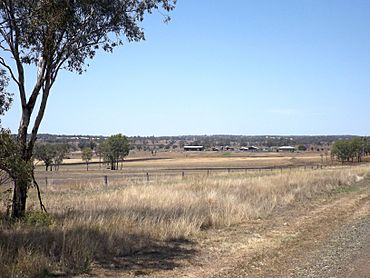
Fields along Oakey Biddleston Road, 2014
|
|||||||||||||||
| Population | 269 (2021 census) | ||||||||||||||
| • Density | 3.645/km2 (9.44/sq mi) | ||||||||||||||
| Postcode(s) | 4401 | ||||||||||||||
| Area | 73.8 km2 (28.5 sq mi) | ||||||||||||||
| Time zone | AEST (UTC+10:00) | ||||||||||||||
| Location | |||||||||||||||
| LGA(s) | Toowoomba Region | ||||||||||||||
| State electorate(s) | Condamine | ||||||||||||||
| Federal Division(s) | Groom | ||||||||||||||
|
|||||||||||||||
Biddeston is a small rural town. It is located in the Toowoomba Region of Queensland, Australia. In 2021, about 269 people lived in Biddeston. It is a quiet area with lots of countryside.
Contents
A Look at Biddeston's Past
Biddeston has an interesting history. A school called Crosshill State School opened in 1880. It taught students for many years before closing in 1940.
A place to send mail, called a postal receiving office, started in 1882. It became a full post office in 1927. The Anderson family, who owned Biddeston Farm, ran it. This is likely how the area got its name. The post office closed in 1965.
The official town area was set up in 1890.
Biddeston State School's Story
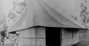
Land was put aside for a school in 1880. But it took a long time for the school to open. Biddeston State School finally opened on October 14, 1919. It started with only 14 children. Their classroom was just a tent!
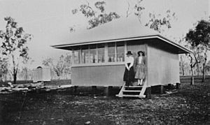
A proper timber building was built in 1921. It was a single room. Even as more students joined, the building wasn't made much bigger. A verandah was added in 1927. In 1954, a second classroom was finally built. A pre-school section was added in 1986.
Another school, Burton Provisional School, opened in 1900. It became Burton State School in 1909. This school closed in 1944. It was located on Toowoomba Cecil Plains Road.
Who Lives in Biddeston?
In 2021, the town of Biddeston had a population of 269 people. The number of people living in Biddeston has changed a bit over the years.
Roads in Biddeston
The main road that goes through Biddeston is the Toowoomba–Cecil Plains Road. It runs from east to west across the area.
What Biddeston Does
Biddeston is a rural area. This means it has many farms and large properties. These properties are often called "homesteads." They are important for farming and agriculture in the region.
Here are some of the homesteads in the area:
- Aberdeen (27°32′24″S 151°44′48″E / 27.5400°S 151.7467°E)
- Aughamore (27°34′06″S 151°43′43″E / 27.5684°S 151.7285°E)
- Bronte Park (27°34′14″S 151°44′40″E / 27.5705°S 151.7445°E)
- Burton (27°32′25″S 151°44′56″E / 27.5404°S 151.7489°E)
- Chelandry (27°34′21″S 151°43′50″E / 27.5726°S 151.7306°E)
- Croxley (27°31′46″S 151°44′31″E / 27.5294°S 151.7419°E)
- Egmont Park (27°36′09″S 151°43′49″E / 27.6024°S 151.7302°E)
- Enterprise (27°30′45″S 151°44′55″E / 27.5125°S 151.7486°E)
- Glen Bride (27°32′21″S 151°44′20″E / 27.5391°S 151.7388°E)
- Glen View (27°35′02″S 151°44′00″E / 27.5838°S 151.7333°E)
- Goldrush Lodge (27°35′03″S 151°43′35″E / 27.5843°S 151.7264°E)
- Hillview (27°34′52″S 151°45′07″E / 27.5810°S 151.7519°E)
- Kerrabee Park (27°32′40″S 151°45′19″E / 27.5445°S 151.7552°E)
- Lange (27°33′17″S 151°43′53″E / 27.5546°S 151.7315°E)
- Martrise (27°32′06″S 151°42′06″E / 27.5349°S 151.7018°E)
- Mayfield (27°32′41″S 151°45′33″E / 27.5448°S 151.7591°E)
- Parklands (27°33′57″S 151°44′31″E / 27.5659°S 151.7419°E)
- Rayhill (27°35′11″S 151°42′41″E / 27.5865°S 151.7114°E)
- Roxanna (27°33′05″S 151°45′04″E / 27.5513°S 151.7511°E)
- Silver Springs (27°35′24″S 151°43′45″E / 27.5899°S 151.7291°E)
- The Towers (27°30′52″S 151°43′20″E / 27.5145°S 151.7221°E)
- Wallaby Hill (27°36′04″S 151°43′56″E / 27.6012°S 151.7323°E)
- Windemere (27°33′02″S 151°45′00″E / 27.5506°S 151.7501°E)
- Ziebel (27°31′13″S 151°43′58″E / 27.5203°S 151.7328°E)
Learning in Biddeston
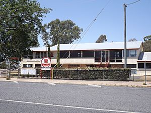
Biddeston State School is a government primary school. It teaches students from Prep to Year 6. Both boys and girls attend this school. It is located at 2425 Cecil Plains Road. In 2018, the school had 70 students.
There are no high schools directly in Biddeston. Students who want to go to secondary school usually attend Oakey State High School. This school is in the nearby town of Oakey.
Fun Events
One exciting event in Biddeston is the Biddeston Tractor Pull. This is an annual event. People bring their old or specially changed tractors. They compete to see which tractor can pull the heaviest loads. It's a fun day for everyone!
 | Madam C. J. Walker |
 | Janet Emerson Bashen |
 | Annie Turnbo Malone |
 | Maggie L. Walker |


