
Wellcamp, Queensland facts for kids
Quick facts for kids WellcampToowoomba Region, Queensland |
|||||||||||||||
|---|---|---|---|---|---|---|---|---|---|---|---|---|---|---|---|

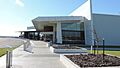
Approach to the passenger terminal, Toowoomba Wellcamp Airport, 2016
|
|||||||||||||||

Wellcamp
Location in Queensland
|
|||||||||||||||
| Population | 346 (2021 census) | ||||||||||||||
| • Density | 7.090/km2 (18.36/sq mi) | ||||||||||||||
| Postcode(s) | 4350 | ||||||||||||||
| Area | 48.8 km2 (18.8 sq mi) | ||||||||||||||
| Time zone | AEST (UTC+10:00) | ||||||||||||||
| Location |
|
||||||||||||||
| LGA(s) | Toowoomba Region | ||||||||||||||
| State electorate(s) | Condamine | ||||||||||||||
| Federal Division(s) | Groom | ||||||||||||||
|
|||||||||||||||
Wellcamp is a small rural area in the Toowoomba Region of Queensland, Australia. It's known for its airport and peaceful country setting. In 2021, about 346 people lived in Wellcamp.
Contents
What is Wellcamp Like?
Wellcamp is a quiet rural area. It has wide-open spaces and is a great place for farming. It is located west of the city of Toowoomba.
Wellcamp Airport: A Hub for Travel

One of the most important places in Wellcamp is the Toowoomba Wellcamp Airport. This airport helps people travel to and from Toowoomba and nearby areas. It is located on Toowoomba-Cecil Plains Road.
The airport was built by a local company called Wagners. They also own and run the airport. It first opened in November 2014.
Roads and Travel in Wellcamp
The Toowoomba Bypass is a major road that goes through Wellcamp. It helps traffic move smoothly from north to south. This bypass also connects to Toowoomba–Cecil Plains Road, which leads to the airport and to Cecil Plains.
Wellcamp's Past
Wellcamp has an interesting history. It was named a long time ago by the Queensland Railways Department.
How Wellcamp Got Its Name
The name "Wellcamp" came from a camp where workers stayed. These workers were building the Toowoomba–Hendon railway. Their camp was right next to a well, which is how the name "Wellcamp" came about. The railway line opened in 1869.
Schools and Churches in Early Wellcamp
Wellcamp Provisional School first opened its doors on February 27, 1899. A few years later, in 1909, it became Wellcamp State School.
There was also a church in Wellcamp. The Wellcamp Methodist Church opened in 1905 but closed in 1932. It was located near the Wellcamp State School.
Learning in Wellcamp
Wellcamp has its own primary school, which is a special part of the community.
Wellcamp State School

Wellcamp State School is a government primary school. It teaches students from Prep (the first year of school) up to Year 6. The school is located on Drayton-Wellcamp Road.
In 2017, the school had 77 students. By 2018, the number of students grew to 95. This shows that the school is an important place for children in the area.
High School Options
Wellcamp does not have its own government high school. Students who live in Wellcamp usually go to high schools in nearby towns. Some of these schools include:
- Wilsonton State High School in Wilsonton
- Harristown State High School in Harristown
- Oakey State High School in Oakey
Images for kids
-
Approach to the passenger terminal, Toowoomba Wellcamp Airport, 2016
