Cecil Plains, Queensland facts for kids
Quick facts for kids Cecil PlainsQueensland |
|||||||||||||||
|---|---|---|---|---|---|---|---|---|---|---|---|---|---|---|---|

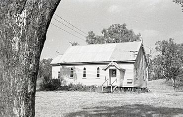
St. Margaret's Anglican Church, 1975
|
|||||||||||||||
| Population | 380 (2021 census) | ||||||||||||||
| • Density | 1.049/km2 (2.72/sq mi) | ||||||||||||||
| Postcode(s) | 4407 | ||||||||||||||
| Area | 362.2 km2 (139.8 sq mi) | ||||||||||||||
| Time zone | AEST (UTC+10:00) | ||||||||||||||
| Location | |||||||||||||||
| LGA(s) | Toowoomba Region | ||||||||||||||
| State electorate(s) |
|
||||||||||||||
| Federal Division(s) | Maranoa | ||||||||||||||
|
|||||||||||||||
Cecil Plains is a small town and area in the Toowoomba Region of Queensland, Australia. It's a rural place, meaning it's mostly countryside with farms. In 2021, about 380 people lived in Cecil Plains.
Contents
What is Cecil Plains Like?
Cecil Plains is located in a very rich farming area called the Darling Downs. It's about 217 kilometers (135 miles) west of Brisbane, the capital city of Queensland. The soil here is very fertile and black, which is perfect for growing cotton. In fact, Cecil Plains is home to one of the biggest cotton processing factories (called a cotton gin) in the southern part of the world!
How to Get Around Cecil Plains
Several roads connect Cecil Plains to other towns. These include the Pampas-Horrane Road, Toowoomba–Cecil Plains Road, Dalby–Cecil Plains Road, Millmerran-Cecil Plains Road, and Cecil Plains-Moonie Road. These roads help farmers transport their crops and people travel to and from the town.
A Look Back: History of Cecil Plains
Cecil Plains has a long and interesting history, starting with its first European settlers.
Early Days and the Station
European settlement in this area began in 1842. A man named Henry Stuart Russell claimed land near the Condamine River and started a large farm called Cecil Plains Station. The town of Cecil Plains grew up around where this farm's main house was.
The famous explorer Ludwig Leichhardt even used the station as a base for his trips into the surrounding region in 1844 and 1847. The station first raised cattle, but later switched to producing wool from sheep.
How Cecil Plains Got Its Name
The town of Cecil Plains was named after the large farm, Cecil Plains Station. The station itself was named after Henry Stuart Russell's mother, Cecil Charlotte Russell.
Growing the Community
In 1877, a large part of the Cecil Plains Station land was divided into smaller farms. This allowed more people to settle in the area and start their own farms.
The first school, Cecil Plains Provisional School, opened on January 17, 1898. It later became Cecil Plains State School in 1922. In 1964, a secondary department was added, meaning older students could continue their education there. A pre-school also opened in 1975.
In 1916, the Queensland government bought Cecil Plains Station. They divided it into even more smaller farms, including some for soldiers who had returned from war. These new farmers mainly grew wheat and produced dairy products.
The Cecil Plains railway line reached the town in 1919, making it easier to transport goods and people. A post office opened in 1921, helping people send and receive mail.
Churches and Community Life
The first Anglican church, St Margaret's, was built in Cecil Plains and opened in 1927. The Our Lady of Lourdes Catholic Church was officially opened in 1930. These churches became important places for the community.
A police station opened in 1934, helping to keep the town safe. The local pub, called the Victory Hotel, opened in 1938 after the town voted for it. A Presbyterian church also opened in 1938.
Cecil Plains During World War II
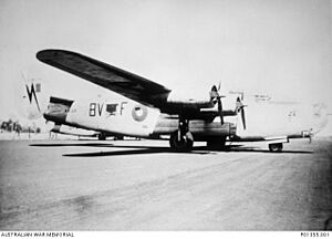
During World War II, an airfield was built near Cecil Plains in 1942. It was called Cecil Plains Airfield (or Tipton Airfield). It was originally built for US Air Force planes, but it was mainly used by the Royal Australian Air Force (RAAF). From 1944 to 1945, RAAF squadrons, including the 12 Squadron and 102 Squadron, used the airfield for their planes, like the B-24 Liberators. You can still see the old runways from the air today!
Cotton Becomes King
Starting in the 1960s, cotton became the most important crop grown in the Cecil Plains area. This led to the large cotton gin that is there today.
Fun Things to Do in Cecil Plains
Cecil Plains has some great places for recreation and fun.
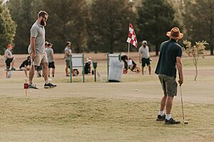
- The Cecil Plains Golf Club is a popular spot for golf enthusiasts.
- Apex Park, located at the Cecil Plains Weir, is a nice place to relax and enjoy the outdoors.
Important Places in Cecil Plains
Cecil Plains has several important services and community spots.
Library Services
The Cecil Plains Library is run by the Toowoomba Regional Council. It opened in 1987 and is located on Taylor Street. It's open a few days a week and offers public Wi-Fi, books, and other resources.
Churches
- St Margaret's Anglican Church holds services every two weeks. It's part of the Dalby parish and is located on Watson Street.
- Our Lady of Lourdes Catholic Church is on Geraghty Street and holds monthly services.
Education
Cecil Plains State School is a government school for both primary and early secondary students (from Prep to Year 9). It's located on Taylor Street. In 2018, about 65 students attended the school.
For students who want to continue their education up to Year 12, the nearest high school is Dalby State High School in Dalby.
 | Mary Eliza Mahoney |
 | Susie King Taylor |
 | Ida Gray |
 | Eliza Ann Grier |


