Checotah, Oklahoma facts for kids
Quick facts for kids
Checotah, Oklahoma
|
|
|---|---|
|
Town
|
|

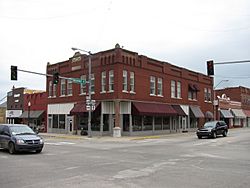
Kniseley and Long Building
|
|
| Nicknames:
Steer Wrestling Capital of the World, Gem of the Prairie
|
|

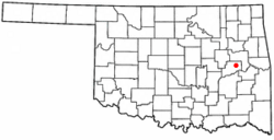
Location of Checotah, Oklahoma
|
|
| Country | United States |
| State | Oklahoma |
| County | McIntosh |
| Area | |
| • Total | 9.03 sq mi (23.39 km2) |
| • Land | 8.96 sq mi (23.22 km2) |
| • Water | 0.06 sq mi (0.17 km2) |
| Elevation | 620 ft (190 m) |
| Population
(2020)
|
|
| • Total | 3,018 |
| • Density | 336.64/sq mi (129.97/km2) |
| Time zone | UTC-6 (Central (CST)) |
| • Summer (DST) | UTC-5 (CDT) |
| ZIP code |
74426
|
| Area code(s) | 539/918 |
| FIPS code | 40-13650 |
| GNIS feature ID | 2409438 |
Checotah is a town located in McIntosh County, Oklahoma, in the United States. It was named after Samuel Checote, who was the first chief of the Creek Nation elected after the American Civil War.
Checotah is known for its many antique shops and a historic area downtown. It also claims to be the "Steer Wrestling Capital of the World." Long ago, people called Checotah "The Gem of the Prairie" because it was such a special place.
Contents
History of Checotah
How Checotah Started
Checotah began in 1872 when the Missouri–Kansas–Texas Railroad (also called the Katy) built a railway stop. This stop was on an old road called the Texas Road. The town was first named Checote Switch, after Samuel Checote. But later, a mapmaker spelled it as Checotah.
The Creek Nation officially recognized the town in 1893. An important group called the Dawes Commission held its first meeting here.
The McIntosh County Seat War
Between 1907 and 1909, Checotah had a disagreement with a nearby town called Eufaula. This fight was about which town should be the main government center, or "county seat," for McIntosh County.
Checotah was chosen as the new county seat. However, the people of Eufaula did not want to give up the county records. A group of armed men from Checotah tried to take the records from Eufaula's courthouse. But they were stopped in a gunfight. Eufaula was later chosen as the permanent county seat.
Old Roads and Highways
In 1915, Checotah became part of the Jefferson Highway. This long road stretched over 2,300 miles. It connected Winnipeg, Manitoba, Canada, all the way to New Orleans, Louisiana, in the United States.
Geography of Checotah
Where is Checotah Located?
Checotah is about 652 feet (199 meters) above sea level. It is located where two major roads meet: I-40 and U.S. Route 69.
Nearby Lakes and Land
Close to Checotah is Eufaula Lake. This is the largest lake that is completely within the state of Oklahoma.
The town covers a total area of about 9.0 square miles (23.3 square kilometers). A small part of this area, about 0.1 square miles (0.17 square kilometers), is covered by water.
Population and People
| Historical population | |||
|---|---|---|---|
| Census | Pop. | %± | |
| 1900 | 805 | — | |
| 1910 | 1,683 | 109.1% | |
| 1920 | 2,390 | 42.0% | |
| 1930 | 2,110 | −11.7% | |
| 1940 | 2,126 | 0.8% | |
| 1950 | 2,638 | 24.1% | |
| 1960 | 2,614 | −0.9% | |
| 1970 | 3,074 | 17.6% | |
| 1980 | 3,454 | 12.4% | |
| 1990 | 3,290 | −4.7% | |
| 2000 | 3,481 | 5.8% | |
| 2010 | 3,335 | −4.2% | |
| 2020 | 3,018 | −9.5% | |
| U.S. Decennial Census | |||
How Many People Live Here?
In 2000, about 3,481 people lived in Checotah. By 2020, the population was 3,018.
Who Lives in Checotah?
In 2000, there were about 1,389 households in the town. Many households had children under 18 living with them. About 45% of households were married couples. Some households had a female head without a husband.
The average household had about 2 to 3 people. The average age of people in Checotah was 39 years old. About 26% of the population was under 18. About 22% of the population was 65 or older.
The average yearly income for a household was around $22,029. Some families and individuals in Checotah earned less money.
Historic Places to See
National Register of Historic Places
Checotah has several buildings and areas listed on the National Register of Historic Places. These are important places that are kept safe because of their history.
Some of these places include:
- The Checotah Business District
- Checotah City Hall
- The Checotah MKT Depot
- The Methodist Episcopal Church (South)
- The Oklahoma Odd Fellows Home at Checotah
- The Tabor House
Honey Springs Battlefield
Checotah is considered the host town for the Honey Springs Battlefield. This important historical site is about 4.5 miles (7.2 kilometers) northeast of the town. It was the location of a significant battle during the Civil War.
Famous People from Checotah
Many notable people have connections to Checotah, including:
- Paul H. Carr, a brave sailor who received the Silver Star award.
- Woody Crumbo, a Native American artist who lived and worked in Checotah.
- Merle Haggard's parents, James Francis Haggard and Flossie Mae Harp.
- Jim G. Lucas, a journalist and war reporter who won a Pulitzer Prize.
- Mel McDaniel, a country music singer.
- Tracy Scroggins, a professional football player (linebacker) in the NFL.
- Carrie Underwood, a famous country music singer who has won many Grammy Awards.
See also
 In Spanish: Checotah (Oklahoma) para niños
 | Laphonza Butler |
 | Daisy Bates |
 | Elizabeth Piper Ensley |


