Cherry Creek (Tuolumne River tributary) facts for kids
Quick facts for kids Cherry Creek |
|
|---|---|

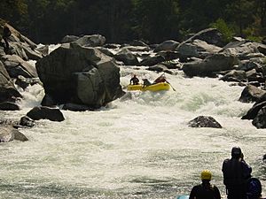
Rafters on Mushroom Rapid in Cherry Creek, June 2002
|
|

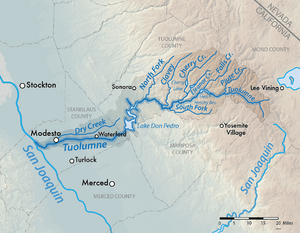
Map of the Tuolumne River watershed, including Cherry Creek
|
|
| Country | United States |
| State | California |
| Physical characteristics | |
| Main source | Sierra Nevada Emigrant Wilderness, Tuolumne County 7,119 ft (2,170 m) 38°05′54″N 119°47′23″W / 38.09833°N 119.78972°W |
| River mouth | Tuolumne River West of Mather, Tuolumne County 2,162 ft (659 m) 37°53′19″N 119°58′19″W / 37.88861°N 119.97194°W |
| Length | 26 mi (42 km) |
| Basin features | |
| Basin size | 234 sq mi (610 km2) |
Cherry Creek is a big, fast-moving stream in the Sierra Nevada mountains. It's the largest stream that flows into the Tuolumne River. The main part of Cherry Creek is about 26 miles (42 km) long. Its whole water area, called a watershed, covers 234 square miles (610 km2) in the Stanislaus National Forest. A small part of this area also reaches into Yosemite National Park.
Contents
Where Cherry Creek Flows
Cherry Creek starts where its North and East Forks meet. This spot is called Lord Meadow, and it's about 7,119 feet (2,170 m) high. It's in the Emigrant Wilderness area.
The creek then flows through a deep canyon made of granite rock. It eventually flows into Cherry Lake. This is a large lake created by the Cherry Valley Dam.
Below the dam, another stream called Eleanor Creek joins Cherry Creek. Cherry Creek then continues for about 10 miles (16 km). It flows through foothills of the Sierra Nevada. Finally, it meets the Tuolumne River. This meeting point is about 6 miles (9.7 km) west of Mather.
The Forks of Cherry Creek
Cherry Creek has several smaller streams, or "forks," that feed into it.
East Fork Cherry Creek
The East Fork is about 13 miles (21 km) long. It begins near Bigelow Peak at a high elevation of 9,399 feet (2,865 m). It flows southwest through Huckleberry Lake. Then it drops steeply to meet the North Fork.
North Fork Cherry Creek
The North Fork is about 14 miles (23 km) long. It starts at High Emigrant Lake, which is 9,711 feet (2,960 m) high. It flows through several lakes, including Emigrant Lake. After that, it goes through a canyon to meet the East Fork.
West Fork Cherry Creek
The West Fork is about 18 miles (29 km) long. It starts at the Pinto Lakes, at 9,383 feet (2,860 m). It picks up other streams like Spring Creek and Buck Meadow Creek. It joins the main Cherry Creek about a mile (1.6 km) before Cherry Lake.
Eleanor Creek
Eleanor Creek is a main stream that flows into the lower part of Cherry Creek. It starts inside Yosemite National Park. It flows into Lake Eleanor, which is a natural lake made bigger by a dam. After the dam, it flows through a short, steep canyon before joining Cherry Creek.
How People Use Cherry Creek
For a long time, people have used the Cherry Creek area. They use it to make electricity, supply water, and control floods.
Early Dams and Power
The first dam in the Cherry Creek area was the Lake Eleanor Dam. It was built in 1918. This dam was part of the Hetch Hetchy Project. This project helps provide water and power to the city of San Francisco. The electricity from Lake Eleanor helped build other dams and tunnels for the Hetch Hetchy Project.
Cherry Valley Dam and Cherry Lake
Building the Cherry Valley Dam started in 1953 and finished in 1955. This dam created Cherry Lake on the main Cherry Creek. The dam is 315-foot (96 m) high. It was built by San Francisco and other water districts.
Cherry Lake can hold a lot of water, about 273,500 acre-feet (337,400,000 m3). It's connected to Lake Eleanor by a tunnel. This means the two lakes can work together. They provide drinking water and help prevent floods for towns in the Central Valley.
The water from Cherry Lake also makes electricity. It flows through a 6-mile (9.7 km) long tunnel to the Dion R. Holm Powerhouse. The water drops 2,100 feet (640 m), which powers two generators. These generators can make 165,000 kilowatts of electricity.
Animals in Cherry Creek
Cherry Creek is home to different kinds of fish. Some fish are native, meaning they've always lived there. Others were brought in by people.
You can find brown bullhead, brown trout, and golden shiner fish in the creek. In the upper parts of Cherry Creek, there are wild brook trout. In the lower creek, you might see green sunfish.
A long time ago, before dams were built on the Tuolumne River, chinook salmon and steelhead trout used to swim up Cherry Creek every year.
Fun Things to Do at Cherry Creek
The areas where Cherry Creek starts are very beautiful. They have granite valleys that look a bit like Yosemite Valley. However, you can only reach these areas by hiking with a backpack.
If you like adventure, you can go whitewater rafting on parts of Cherry Creek. This is considered very difficult, in the Class V/V+ category. Some people say it's one of the hardest rivers for commercial rafting in the country!
 | Kyle Baker |
 | Joseph Yoakum |
 | Laura Wheeler Waring |
 | Henry Ossawa Tanner |

