Chinook, Montana facts for kids
Quick facts for kids
Chinook
|
|
|---|---|
 |
|

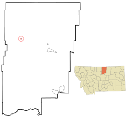
Location of Chinook, Montana
|
|
| Country | United States |
| State | Montana |
| County | Blaine |
| Area | |
| • Total | 0.52 sq mi (1.35 km2) |
| • Land | 0.52 sq mi (1.35 km2) |
| • Water | 0.00 sq mi (0.00 km2) |
| Elevation | 2,425 ft (739 m) |
| Population
(2020)
|
|
| • Total | 1,185 |
| • Density | 2,265.77/sq mi (875.33/km2) |
| Time zone | UTC-7 (Mountain (MST)) |
| • Summer (DST) | UTC-6 (MDT) |
| ZIP codes |
59523, 59535
|
| Area code(s) | 406 |
| FIPS code | 30-14575 |
| GNIS feature ID | 2409455 |
Chinook is a small city in Montana, United States. It is the main town, or county seat, of Blaine County. In 2020, about 1,185 people lived there.
Chinook is known for its history. You can visit the Bear Paw Battlefield Museum in the city center. The actual Bear Paw Battlefield is about 20 miles (32 km) south of town. This was an important site in American history.
Contents
Why is it Called Chinook?
The city of Chinook gets its name from the Chinook wind. This is a special warm wind that blows on the eastern side of the Rocky Mountains.
The Gros Ventre people have their own name for the town: ʔaasíccóóútaanʔɔ. This means 'thinker town'. It's said to be named after a man called Thinker. He was part Native American and part white. His English name was Thomas O'Hanlon. He started the town back in 1871.
Where is Chinook Located?
Chinook is located right where Lodge Creek flows into the Milk River. The Milk River runs just south of the town.
The city covers a total area of about 0.51 square miles (1.32 square kilometers). All of this area is land.
What is the Climate Like?
Chinook has a semi-arid climate. This means it's quite dry. Winters are long, cold, and dry. Summers are hot and get more rain.
| Climate data for Chinook, Montana (1991–2020 normals, extremes 1895–present) | |||||||||||||
|---|---|---|---|---|---|---|---|---|---|---|---|---|---|
| Month | Jan | Feb | Mar | Apr | May | Jun | Jul | Aug | Sep | Oct | Nov | Dec | Year |
| Record high °F (°C) | 69 (21) |
75 (24) |
82 (28) |
94 (34) |
98 (37) |
109 (43) |
110 (43) |
109 (43) |
104 (40) |
90 (32) |
82 (28) |
70 (21) |
110 (43) |
| Mean maximum °F (°C) | 54.8 (12.7) |
56.1 (13.4) |
66.9 (19.4) |
78.9 (26.1) |
86.3 (30.2) |
92.3 (33.5) |
98.1 (36.7) |
97.9 (36.6) |
91.4 (33.0) |
79.1 (26.2) |
65.7 (18.7) |
55.6 (13.1) |
99.7 (37.6) |
| Mean daily maximum °F (°C) | 27.1 (−2.7) |
31.4 (−0.3) |
43.0 (6.1) |
56.9 (13.8) |
67.0 (19.4) |
75.4 (24.1) |
84.3 (29.1) |
83.3 (28.5) |
72.3 (22.4) |
56.9 (13.8) |
41.3 (5.2) |
30.5 (−0.8) |
55.8 (13.2) |
| Daily mean °F (°C) | 15.7 (−9.1) |
19.2 (−7.1) |
30.4 (−0.9) |
43.1 (6.2) |
53.5 (11.9) |
62.4 (16.9) |
69.0 (20.6) |
67.5 (19.7) |
56.8 (13.8) |
42.7 (5.9) |
29.2 (−1.6) |
19.0 (−7.2) |
42.4 (5.8) |
| Mean daily minimum °F (°C) | 4.2 (−15.4) |
6.9 (−13.9) |
17.7 (−7.9) |
29.4 (−1.4) |
40.0 (4.4) |
49.3 (9.6) |
53.6 (12.0) |
51.7 (10.9) |
41.2 (5.1) |
28.5 (−1.9) |
17.0 (−8.3) |
7.5 (−13.6) |
28.9 (−1.7) |
| Mean minimum °F (°C) | −24.1 (−31.2) |
−17.8 (−27.7) |
−5.2 (−20.7) |
15.2 (−9.3) |
26.1 (−3.3) |
38.2 (3.4) |
44.5 (6.9) |
40.5 (4.7) |
27.9 (−2.3) |
10.9 (−11.7) |
−6.0 (−21.1) |
−16.9 (−27.2) |
−32.0 (−35.6) |
| Record low °F (°C) | −50 (−46) |
−51 (−46) |
−38 (−39) |
−13 (−25) |
11 (−12) |
28 (−2) |
32 (0) |
30 (−1) |
13 (−11) |
−24 (−31) |
−38 (−39) |
−53 (−47) |
−53 (−47) |
| Average precipitation inches (mm) | 0.45 (11) |
0.37 (9.4) |
0.59 (15) |
1.04 (26) |
2.42 (61) |
2.86 (73) |
1.62 (41) |
1.14 (29) |
0.99 (25) |
0.88 (22) |
0.69 (18) |
0.39 (9.9) |
13.44 (341) |
| Average snowfall inches (cm) | 6.8 (17) |
6.4 (16) |
4.7 (12) |
1.6 (4.1) |
0.7 (1.8) |
0.0 (0.0) |
0.0 (0.0) |
0.0 (0.0) |
0.1 (0.25) |
1.2 (3.0) |
6.3 (16) |
6.0 (15) |
33.8 (85.15) |
| Average extreme snow depth inches (cm) | 7.6 (19) |
7.2 (18) |
7.3 (19) |
1.8 (4.6) |
0.6 (1.5) |
0.0 (0.0) |
0.0 (0.0) |
0.0 (0.0) |
0.1 (0.25) |
1.2 (3.0) |
4.1 (10) |
5.3 (13) |
13.7 (35) |
| Average precipitation days (≥ 0.01 in) | 4.8 | 4.6 | 4.6 | 6.4 | 9.7 | 11.4 | 7.2 | 5.4 | 6.5 | 5.5 | 5.5 | 4.9 | 76.5 |
| Average snowy days (≥ 0.1 in) | 4.0 | 4.1 | 2.9 | 0.7 | 0.3 | 0.0 | 0.0 | 0.0 | 0.1 | 0.8 | 3.5 | 3.6 | 20.0 |
| Source: NOAA | |||||||||||||
Who Lives in Chinook?
| Historical population | |||
|---|---|---|---|
| Census | Pop. | %± | |
| 1910 | 780 | — | |
| 1920 | 1,217 | 56.0% | |
| 1930 | 1,320 | 8.5% | |
| 1940 | 2,051 | 55.4% | |
| 1950 | 2,307 | 12.5% | |
| 1960 | 2,326 | 0.8% | |
| 1970 | 1,813 | −22.1% | |
| 1980 | 1,660 | −8.4% | |
| 1990 | 1,512 | −8.9% | |
| 2000 | 1,386 | −8.3% | |
| 2010 | 1,203 | −13.2% | |
| 2020 | 1,185 | −1.5% | |
| U.S. Decennial Census | |||
In 2010, there were 1,203 people living in Chinook. There were 599 households, which are groups of people living together.
Most people in Chinook are White (88.4%). About 9.3% are Native American. A small number of people are Asian or from other backgrounds.
The average age in Chinook in 2010 was about 46.7 years old. About 21.4% of the people were under 18. About 23.4% were 65 or older.
Chinook High School's Unique Mascot
Chinook High School is famous for its unusual mascot: the Sugarbeeter! This mascot even placed third in a national contest by USA Today for the oddest mascot. It has been featured in many articles.
The name "Sugarbeeters" started in 1929. The Utah-Idaho Sugar Company, which had a factory in Chinook, helped buy jerseys for the boys' basketball team. These jerseys had a sugar beet logo on them. Since then, the nickname has stuck!
Learning in Chinook
Chinook Public Schools teach students from kindergarten all the way through 12th grade. Chinook High School is considered a Class C school. This means it has fewer than 108 students. This class size helps decide how athletic competitions are organized.
The city is also home to the Blaine County Library, where you can find many books and resources.
Local News and Radio
Chinook has its own local weekly newspaper called the Blaine County Journal News-Opinion. You can read it in print or online.
There's also a local FM radio station, KRYK, based in Chinook. It plays popular music, known as "hot adult contemporary."
Getting Around Chinook
U.S. Route 2 is a major road that goes through the northern part of Chinook. It runs from east to west.
For air travel, the Edgar G. Obie Airport is just 1 mile (1.6 km) west of town. It's a public airport. If you need a commercial flight, the closest airport is Havre City–County Airport, about 22 miles (35 km) to the west.
One Health provides healthcare services to Blaine County. They have clinics in both Chinook and Harlem, Montana.
Famous People from Chinook
- Elliott Blackstone: He was a police sergeant in San Francisco. He worked hard to support LGBT rights for a long time.
- Chet Blaylock: He was a member of the Montana State Senate. He used to teach at a school in Chinook.
- U.S. Grant Sharp, Jr.: He was a four-star admiral in the United States Navy. He was the Commander in Chief of the United States Pacific Fleet.
See also
 In Spanish: Chinook (Montana) para niños
 | Delilah Pierce |
 | Gordon Parks |
 | Augusta Savage |
 | Charles Ethan Porter |

