
Chirripó National Park facts for kids
Quick facts for kids Chirripó National Park |
|
|---|---|
|
IUCN Category II (National Park)
|
|
 |
|
| Location | Costa Rica |
| Nearest city | San Isidro de El General |
| Area | 50,849 hectares (125,650 acres) |
| Established | August 19, 1975 |
| Governing body | National System of Conservation Areas (SINAC) |
Chirripó National Park is a very special national park in Costa Rica. It is located in the Talamanca Mountain range. The park is about 20 km (12 mi) northeast of San Isidro de El General. This amazing park is also part of La Amistad International Park. That park stretches across both Costa Rica and Panama. Chirripó National Park was officially created on August 19, 1975. It covers a huge area of about 50,150 ha (123,923 acres). The park is home to the highest mountain in Costa Rica, called Cerro Chirripó. This tall mountain reaches an altitude of 3,920 m (12,861 ft).
Contents
What Does Chirripó Mean?
In the native language, the word "Chirripó" means Land of Eternal Waters. This name makes a lot of sense! The park protects many important rivers. These include the Rio Chirripó Atlántico, Rio Telire, Rio Chirripó Pacífico, and the Rio Ceibo.
Weather in the Park
The weather in Chirripó National Park changes a lot. It depends on how high up you are. The lowest temperature ever recorded in Costa Rica was −9 °C (16 °F). This cold temperature happened on Mount Chirripó. The warmer season runs from December to May. It is usually best to visit the park during these months.
Plants and Animals
Chirripó National Park has many different habitats. This is because of the big changes in altitude and climate. You can find large trees here, like oak and sweet cedar. There are also many beautiful types of orchids. The most common animals you might see in this region are coyotes, jaguars, squirrels, frogs, rabbits, and quetzals.
Climbing Mount Chirripó
The first person known to have climbed Mount Chirripó was a priest named Agustin Blessing. He made the climb in 1904. Other expeditions happened before the park was created. These were in 1905, 1913, 1915, 1920, 1932, and 1942. Today, the park has clear trails that lead to the top of the mountain. There is also a ranger station to help visitors.
Images for kids
-
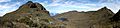
The Valle de los Lagos in Chirripó National Park.
-
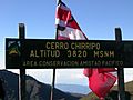
Cerro Chirripó.
-
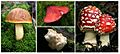
Fungi of Chirripo National Park.


See also
 In Spanish: Parque nacional Chirripó para niños
