Chisago City, Minnesota facts for kids
Quick facts for kids
Chisago City
|
|
|---|---|

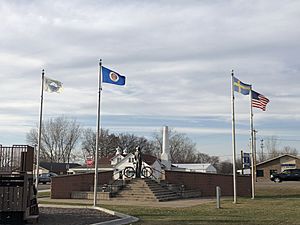
Statue of Vilhelm Moberg in downtown Chisago City
|
|
| Motto(s):
"Gateway to the Lakes"
|
|

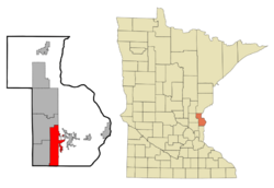
Location of Chisago City
within Chisago County, Minnesota |
|
| Country | United States |
| State | Minnesota |
| County | Chisago |
| Area | |
| • Total | 14.78 sq mi (38.28 km2) |
| • Land | 12.56 sq mi (32.53 km2) |
| • Water | 2.22 sq mi (5.75 km2) |
| Elevation | 919 ft (280 m) |
| Population
(2020)
|
|
| • Total | 5,558 |
| • Density | 442.52/sq mi (170.85/km2) |
| Time zone | UTC-6 (Central (CST)) |
| • Summer (DST) | UTC-5 (CDT) |
| ZIP code |
55013
|
| Area code(s) | 651 |
| FIPS code | 27-11350 |
| GNIS feature ID | 663797 |
| Website | www.ci.chisago.mn.us |
Chisago City is a city in Chisago County, Minnesota, in the United States. It is about 35 miles northeast of the big cities of Minneapolis–Saint Paul. In 2020, about 5,558 people lived there.
Chisago City is special because it sits between two beautiful lakes: Chisago Lake and Green Lake. It is part of a larger area known as the Chisago lakes region.
Contents
Exploring Chisago City's Location
Chisago City is located in the state of Minnesota. It covers a total area of about 14.99 square miles (38.28 square kilometers). Most of this area, about 12.53 square miles (32.53 square kilometers), is land. The rest, about 2.46 square miles (5.75 square kilometers), is water, mainly from its two lakes.
Weather in Chisago City
Chisago City experiences all four seasons. Summers are usually warm, and winters are cold with snow. The weather can change quite a bit throughout the year.
| Climate data for Chisago City, Minnesota (1991–2020 normals, extremes 1958–present) | |||||||||||||
|---|---|---|---|---|---|---|---|---|---|---|---|---|---|
| Month | Jan | Feb | Mar | Apr | May | Jun | Jul | Aug | Sep | Oct | Nov | Dec | Year |
| Record high °F (°C) | 57 (14) |
65 (18) |
81 (27) |
91 (33) |
95 (35) |
100 (38) |
104 (40) |
102 (39) |
96 (36) |
91 (33) |
76 (24) |
65 (18) |
104 (40) |
| Mean daily maximum °F (°C) | 24.2 (−4.3) |
30.1 (−1.1) |
43.0 (6.1) |
57.6 (14.2) |
69.8 (21.0) |
79.1 (26.2) |
83.4 (28.6) |
81.5 (27.5) |
73.7 (23.2) |
59.9 (15.5) |
43.0 (6.1) |
28.9 (−1.7) |
56.2 (13.4) |
| Daily mean °F (°C) | 13.6 (−10.2) |
18.2 (−7.7) |
31.0 (−0.6) |
45.1 (7.3) |
57.6 (14.2) |
67.6 (19.8) |
71.8 (22.1) |
69.9 (21.1) |
61.9 (16.6) |
48.5 (9.2) |
33.3 (0.7) |
19.8 (−6.8) |
44.9 (7.2) |
| Mean daily minimum °F (°C) | 3.0 (−16.1) |
6.3 (−14.3) |
18.9 (−7.3) |
32.6 (0.3) |
45.4 (7.4) |
56.0 (13.3) |
60.2 (15.7) |
58.3 (14.6) |
50.0 (10.0) |
37.1 (2.8) |
23.6 (−4.7) |
10.7 (−11.8) |
33.5 (0.8) |
| Record low °F (°C) | −38 (−39) |
−37 (−38) |
−32 (−36) |
2 (−17) |
21 (−6) |
33 (1) |
42 (6) |
41 (5) |
25 (−4) |
13 (−11) |
−20 (−29) |
−37 (−38) |
−38 (−39) |
| Average precipitation inches (mm) | 0.88 (22) |
0.90 (23) |
1.70 (43) |
3.00 (76) |
4.36 (111) |
4.48 (114) |
4.70 (119) |
4.03 (102) |
3.18 (81) |
2.91 (74) |
1.80 (46) |
1.17 (30) |
33.11 (841) |
| Average snowfall inches (cm) | 9.6 (24) |
9.3 (24) |
9.2 (23) |
3.7 (9.4) |
0.0 (0.0) |
0.0 (0.0) |
0.0 (0.0) |
0.0 (0.0) |
0.0 (0.0) |
0.6 (1.5) |
7.4 (19) |
11.8 (30) |
51.6 (131) |
| Average precipitation days (≥ 0.01 in) | 8.2 | 6.0 | 7.5 | 9.7 | 11.6 | 12.5 | 10.8 | 10.3 | 9.8 | 10.1 | 6.9 | 8.3 | 111.7 |
| Average snowy days (≥ 0.1 in) | 9.6 | 6.4 | 4.8 | 1.9 | 0.0 | 0.0 | 0.0 | 0.0 | 0.0 | 0.5 | 4.2 | 8.4 | 35.8 |
| Source: NOAA | |||||||||||||
Getting Around Chisago City
Roads and Highways
U.S. Highway 8 is the main road that runs through Chisago City. It helps people travel to and from the community.
Old Railroad Lines
In the past, a railroad line called the Northern Pacific's Taylor Falls Branch used to serve Chisago City. This line is no longer in use today.
The Story of Chisago City
How Chisago City Started
Chisago City was founded in May 1857. It was started by Anders Swenson, who was an immigrant from Småland, a region in Sweden. He was born in 1817 and came to America in 1850. The city got its name from the nearby Chisago Lake.
Early Settlers
In 1852, only a few people had settled in the area. One of the first was John Smith, who arrived that spring. He said there were only five other settlers near Chisago Lake before him.
More Swedish immigrants began to arrive in large numbers between 1853 and 1854. Many of them came from Kronoberg County in Sweden. During the first few years, most of the land around the lake was settled. Later immigrants had to travel further out to find land for their homes.
Moving the Town
Chisago City was first built about a mile south of its current spot. But in 1880, the railroad was built and it didn't go through the original town. So, the whole city decided to move closer to the railroad tracks. This was a common thing for towns to do back then, as railroads were very important for travel and trade.
Who Lives in Chisago City?
| Historical population | |||
|---|---|---|---|
| Census | Pop. | %± | |
| 1880 | 92 | — | |
| 1910 | 276 | — | |
| 1920 | 422 | 52.9% | |
| 1930 | 416 | −1.4% | |
| 1940 | 510 | 22.6% | |
| 1950 | 703 | 37.8% | |
| 1960 | 772 | 9.8% | |
| 1970 | 1,068 | 38.3% | |
| 1980 | 1,634 | 53.0% | |
| 1990 | 2,009 | 22.9% | |
| 2000 | 2,622 | 30.5% | |
| 2010 | 4,967 | 89.4% | |
| 2020 | 5,558 | 11.9% | |
| U.S. Decennial Census | |||
Population Changes
The population of Chisago City has grown quite a lot over the years. In 1880, there were only 92 people living there. By 2020, the population had grown to 5,558 people.
A Look at the 2010 Census
In 2010, there were 4,967 people living in Chisago City. These people lived in 2,051 homes. Most of the people (96.7%) were White. A small number of people were African American, Native American, or Asian. About 1.7% of the population was Hispanic or Latino.
Many homes (29.8%) had children under 18 living there. About half of the homes (51.9%) were married couples. The average age of people in the city was 43.3 years old.
Cities Chisago City is Friends With
Chisago City has a special connection with another city far away. This is called a "sister city" relationship, which helps people from different places learn about each other's cultures.
 Algutsboda, Sweden
See also
 In Spanish: Chisago City (Minnesota) para niños
 | Victor J. Glover |
 | Yvonne Cagle |
 | Jeanette Epps |
 | Bernard A. Harris Jr. |

