Chistochina, Alaska facts for kids
Quick facts for kids
Chistochina
Tsiis Tl’edze’ Caegge
|
|
|---|---|

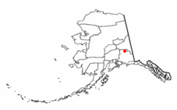
Location of Chistochina, Alaska
|
|
| Country | United States |
| State | Alaska |
| Census Area | Copper River |
| Area | |
| • Total | 368.79 sq mi (955.17 km2) |
| • Land | 368.41 sq mi (954.18 km2) |
| • Water | 0.38 sq mi (0.99 km2) |
| Population
(2020)
|
|
| • Total | 60 |
| • Density | 0.16/sq mi (0.06/km2) |
| Time zone | UTC-9 (Alaska (AKST)) |
| • Summer (DST) | UTC-8 (AKDT) |
| Area code(s) | 907 |
| FIPS code | 02-14000 |
Chistochina is a small community in Alaska, United States. Its name in the Ahtna Athabascan language is Tsiis Tl’edze’ Caegge. In 2020, about 60 people lived there. It is called a "census-designated place" (CDP) because it's a community that the government counts for population, but it's not a city or town with its own local government.
Contents
Where is Chistochina Located?
Chistochina is found in the Copper River Census Area, Alaska. It sits at these coordinates: 62°34′40″N 144°40′11″W.
This community is located along the Tok Cutoff Highway. It is about halfway between the Canada–US border and the city of Anchorage. It is also midway between the towns of Tok and Glennallen.
The total area of Chistochina is about 359.8 square miles (931.9 square kilometers). Most of this area is land, with only a small part being water.
What is the History of Chistochina?
Chistochina started as a fish camp for the Ahtna Athabascan people. It was also a popular stopping point for traders and trappers.
Later, the road that led to the village became part of the Valdez-Eagle Trail. This trail was built by miners during the gold rush in 1897. A place called Chistochina Lodge was built as a roadhouse, offering a place to stay for people looking for gold.
Gold was found and mined along the upper Chistochina River. Over time, families settled in the area. Even today, Chistochina remains one of the most traditional Ahtna Athabascan villages.
Who are the Ahtna Athabascans?
Chistochina is known as the most traditional village of the Ahtna people. It is home to the Cheesh Na' Tribe. The Ahtna people have their own language, called Ahtna Athabascan. They also have their own name for Mount Sanford, which is Kelt'aeni.
How Many People Live in Chistochina?
| Historical population | |||
|---|---|---|---|
| Census | Pop. | %± | |
| 1940 | 34 | — | |
| 1950 | 31 | −8.8% | |
| 1960 | 28 | −9.7% | |
| 1970 | 33 | 17.9% | |
| 1980 | 55 | 66.7% | |
| 1990 | 60 | 9.1% | |
| 2000 | 93 | 55.0% | |
| 2010 | 93 | 0.0% | |
| 2020 | 60 | −35.5% | |
| U.S. Decennial Census | |||
Chistochina first appeared on the U.S. Census in 1940. It was counted as an unincorporated village. Since 1980, it has been listed as a "census-designated area."
In 2020, the population was 60 people. This was a decrease from 93 people in 2010.
About 25.8% of the people living there were under 18 years old. About 16.1% were 65 years or older. The average age of people in Chistochina was 38 years.
Education in Chistochina
The Copper River School District used to run the Chistochina School.
See also
 In Spanish: Chistochina (Alaska) para niños
 | Janet Taylor Pickett |
 | Synthia Saint James |
 | Howardena Pindell |
 | Faith Ringgold |


