Chopaka, British Columbia facts for kids
Quick facts for kids
Chopaka
|
|
|---|---|
| Country | Canada |
| Province | British Columbia |
| Region | Similkameen Country |
| Regional District | Okanagan-Similkameen |
| Area codes | 250, 778, 236, & 672 |
| Highway | |
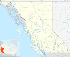
Chopaka is a small community in the Similkameen region of south-central British Columbia, Canada. It is located right next to the Canada–United States border, on the west side of the Similkameen River. The Nighthawk–Chopaka Border Crossing is just to the east. By road, Chopaka is about 96 kilometers (60 miles) southeast of Princeton and 75 kilometers (47 miles) south of Penticton.
Contents
What Does Chopaka Mean?
The name "Chopaka" (pronounced like tobacco) means "lofty" or "grand." It refers to Chopaka Mountain, which is a very tall mountain in the area. The word comes from "c̓up̓áq̓," which can mean "sticking out mountain."
Local stories say that Coyote turned a hunter named Chopaka into stone, or that the mountain is a transformed maiden. Another idea is that the word means soapstone, a type of rock used to make pipes. It might even refer to the pipe itself.
First Nations History
In the early 1700s, different groups of people lived in the South Similkameen area. Later in that century, the Okanagan-speaking peoples gradually became the main group, replacing the Stuwix and Thompson peoples.
When the international border between Canada and the United States was created in 1846, it divided the traditional lands of the Syilx (Okanagan) people. The mouth of the Similkameen River (in the US) was an important winter home for the Okanagans who lived in Canada.
In the late 1870s or early 1880s, a Roman Catholic (RC) church was built in Chopaka. In 1878, land was set aside for First Nations reserves, and these were later changed and made larger in the 1880s. The reserves near the border are called Chopaka 7 and 8.
A new RC church was built in 1890. The reserves were officially mapped in 1889 and listed in 1902. In 1905, the Vancouver, Victoria and Eastern Railway (VV&E) took over about 47 hectares (117 acres) of land across several reserves for their railway tracks. The next year, the band chief said the payment for the land was much too low. A local rancher agreed, but the payment was not changed. The railway construction also involved moving the church away from the new tracks.
It seems that for many years, children from the First Nations community either did not go to school or attended a church boarding school in Washington State, USA.
In 1923, the church got a new cement foundation, a sacristy (a room for church items), and a place for the priest to live.
By the 1960s, a locked gate blocked the old road that used to go across the border next to the railway. Before this, local people could move freely between Canada and the US without much paperwork.
In 1995, the Lower Similkameen Band argued that the railway had not paid enough for the land. They also said that the old railway land, which was no longer used, should become part of the reserve again. The claim was rejected in 1996. However, an investigation into this rejection started in 2003. In 2008, a special Commission agreed that the payment per acre was much lower than for non-reserve lands. They suggested that fair payment should be negotiated. Since the railway no longer needed the land after 1985, the Commission also recommended that this strip of land should legally become reserve land again.
In 2009, when people needed passports to cross the border, First Nations people protested. They cut the barbed wire in this area and symbolically crossed the border line.
In 2015, a new building for the Lower Similkameen Band, used for administration and community events, opened on a hillside near the old Similkameen train station.
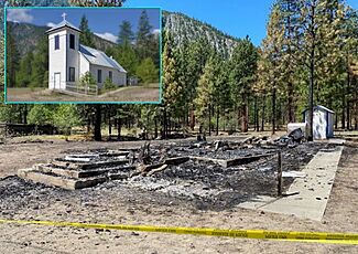
Sadly, in 2021, the Chopaka church burned down in what was thought to be an arson attack.
Railway History
The Great Northern Railway (GN) owned the VV&E railway line. The railway tracks reached the border at Chopaka in April 1907. The railway bridge was about 1 kilometer (0.6 miles) upstream from where the Chopaka Road bridge is today. In May, a train engine crossed on a temporary bridge structure, and track-laying continued on the other side. A few days later, high water damaged part of the temporary structure. By August, temporary repairs were done, but then partly damaged by fire, and repaired again. The permanent bridge was finished in September. It was about 10 kilometers (6 miles) north of the border and had three large wooden howe truss sections.
In 1923, the Great Northern Railway built a barn at the station.
In 1936, the wooden railway bridge was destroyed by fire and then rebuilt.
Passenger train services stopped in the 1950s.
The railway track between the border and Keremeos, which had not been used since a bridge washed out in 1972, was officially closed in 1985.
| GN Train Timetables (Regular stop or Flag stop) | |||||||||||||||
|---|---|---|---|---|---|---|---|---|---|---|---|---|---|---|---|
| Mile | 1909 | 1913 | 1916 | 1922 | 1925 | 1928 | 1931 | 1936 | 1942 | 1942 | 1946 | 1951 | 1955 | 1967 | |
| Keremeos | 38.1 | Reg. | Reg. | Reg. | Reg. | Reg. | Reg. | Reg. | Reg. | Reg. | Reg. | Reg. | Reg. | Reg. | |
| Cawston | 34.2 | Flag | Flag | Flag | Flag | Flag | Flag | Flag | Flag | Flag | Reg. | ||||
| Similkameen, BC | 30.8 | Flag | Flag | Flag | Reg. | Reg. | Reg. | Reg. | Reg. | Reg. | |||||
| Chopaka, WA | 21.2 | Reg. | Reg. | Reg. | Reg. | Reg. | Reg. | Reg. | Reg. | Reg. | Reg. | Reg. | Reg. | Reg. | |
| Nighthawk | 11.3 | Reg. | Reg. | Reg. | Reg. | Reg. | Reg. | Reg. | Reg. | Reg. | Reg. | Reg. | Reg. | Reg. | |
| Oroville | 0.0 | Reg. | Reg. | Reg. | Reg. | Reg. | Reg. | Reg. | Reg. | Reg. | Reg. | Reg. | Reg. | Reg. | |
. This station was initially called Delmar.
Roads and Bridges
The Dewdney Trail, an old route to Osoyoos, passed through this area. Later, a wagon road followed the east side of the river towards the border.
Before the Armstrong rail bridge was built in 1907, the Armstrong family ran a ferry service for many years. In 1931, plans were made for the current Chopaka Road bridge. It's not clear if people used the railway bridge for walking before this, or if another public Chopaka bridge existed nearby in the 1910s.
To help people cross the river when the water was high, a road was built in 1911 on the west side of the river, leading to the border. This gave the Armstrong family and other residents a way to get around. The rebuilding and paving of BC Highway 3A north from Keremeos, finished in 1948, made it so less traffic went through Similkameen.
The wooden bridge that was repaired a lot in 1956–57 was probably the current bridge. In 1964–65, the highway was paved. Travel through to Osoyoos became easier in 1965 when the highway over Richter Pass was completed.
Former Similkameen Community
Bob Stevenson, a miner, arrived in 1860 but soon left. He gave his land to Daniel McCurdy and his family, who came around 1885. That same year, R.C. Armstrong settled on land right next to the Lower Similkameen reserves.
A school was built in Similkameen in the early 1890s. This one-room school was about 7 by 11 meters (24 by 36 feet) and was located about 1.6 kilometers (1 mile) north of the settlement, on the edge of the McCurdy ranch. School was held in the McCurdy family's cabin for three months starting in September 1892, because the schoolhouse wasn't finished yet. R.C. Armstrong's ranch, about 19 kilometers (12 miles) south of Keremeos, marked the southern boundary of the Similkameen school district. By 1897, there was also a sawmill in the area.
Daniel McCurdy was the first postmaster for the Similkameen post office from 1906 to 1919. This post office was about 2.4 kilometers (1.5 miles) south of Cawston. There was also a Chopaka post office that operated from March to October in 1908.
After the Keremeos school opened, fewer students attended the Similkameen school. For long periods, the school was closed because it couldn't get enough students or a teacher. However, the idea that the school closed for good in 1916 when the Cawston school was built is wrong, because 12 students were still enrolled in 1918–19. A few First Nations children may have attended, likely those of mixed heritage, to follow government rules at the time.
Similkameen was also one of the first border outposts in the interior. Daniel McCurdy worked as a customs officer there for four years in the 1910s. By that time, the Armstrong family ran a large sheep ranch.
In 1935, the old schoolhouse burned down. In 1939, the post office closed. Around this time, Similkameen stopped being mentioned as a distinct place. The McCurdy Private Cemetery, on the old McCurdy property, has graves of people who lived in the area but were not part of the McCurdy family. The old McCurdy cabin, once known as the first Lower Similkameen school, is now considered to be within the Chopaka area.
Maps
- VV&E rail line map.
- Okanagan Circuit, 1918.
 | Emma Amos |
 | Edward Mitchell Bannister |
 | Larry D. Alexander |
 | Ernie Barnes |


