
Châtelat facts for kids
Quick facts for kids
Châtelat
|
||
|---|---|---|

Châtelat village
|
||
|
||

Châtelat
Location in Switzerland

Châtelat
Location in Canton of Bern
|
||
| Country | Switzerland | |
| Canton | Bern | |
| District | Jura bernois | |
| Area | ||
| • Total | 4.09 km2 (1.58 sq mi) | |
| Elevation | 802 m (2,631 ft) | |
| Population
(Dec 2011)
|
||
| • Total | 111 | |
| • Density | 27.14/km2 (70.3/sq mi) | |
| Postal code |
2715
|
|
| Surrounded by | Saicourt, Sornetan, Monible, Rebévelier, Lajoux (JU) | |

Châtelat was a small town in Switzerland. It was located in the canton of Bern, in an area called Jura bernois. Even though this area speaks French, most people in Châtelat spoke German. On January 1, 2015, Châtelat joined with three other towns: Monible, Sornetan, and Souboz. Together, they formed a new town called Petit-Val.
Contents
A Look Back: History of Châtelat

The first time Châtelat was ever written about was in the year 1335. Back then, it was called Schestellat.
For a long time, Châtelat was part of the church area of Sornetan. This area was overseen by a religious leader from Moutier-Grandval Abbey. In 1531, during the Protestant Reformation, both Châtelat and Sornetan changed to a new Christian faith. Later, a group of people called Mennonites settled in a village called Moron, which was part of Châtelat. Moron was high up on a mountain and hard to reach, which was common for Mennonite settlements.
In 1797, France won a war and took control of Châtelat. It became part of a French area called Mont-Terrible. Then, in 1800, it became part of another French area called Haut-Rhin. After Napoleon lost power, Châtelat was given to the Canton of Bern in 1815. During the time France was in charge, a village called Fornet-Dessous was its own town. But after Bern took over, Fornet-Dessous became part of Châtelat. Sadly, in 1829, a big fire destroyed Fornet-Dessous.
Today, the area is still mostly rural, meaning it has lots of farms and open land. About two-thirds of the jobs in the town are in farming.
Exploring the Land: Geography of Châtelat

Before it merged, Châtelat covered about 4.2 square kilometers (1.6 square miles). More than half of this land, about 54.9%, was used for farming. A large part, 42.2%, was covered by forests. The rest of the land had buildings and roads (2.7%) or rivers (0.5%).
Most of the forested land was dense forest, and some areas had orchards or small groups of trees. For farming, some land was used for growing crops, and much of it was pastures for animals. All the water in the area came from flowing rivers or streams.
Châtelat was located in a valley called Petit Val. The main village was divided by a road called Pichoux-Strasse. The town included the villages of Châtelat, Moron, and Fornet-Dessous. A nearby village, Fornet-Dessus, belongs to the town of Lajoux.
In 2010, Châtelat became part of a new administrative district called Arrondissement administratif Jura bernois.
Symbols and Meaning: Coat of Arms
The coat of arms for Châtelat shows a black tower on a green hill, with three red stars. The tower looks like a castle, and in French, "château" means castle. This is a clever way the name of the town is shown in its symbol. The three stars represent the three main parts of the town: Châtelat, Fornet, and Moron.
Who Lives Here: Demographics


In 2013, Châtelat had 105 people living there. A small number of these people (2.7%) were not Swiss citizens. Over ten years, the number of people living in Châtelat stayed about the same.
Most people in Châtelat (63.9%) spoke German as their main language. The rest spoke French.
In 2008, there were slightly more men (50.5%) than women (49.5%) living in Châtelat. Most of the people (58.2%) were born in Châtelat and still lived there in 2000.
In 2011, about 27% of the people were children and teenagers (0-19 years old). Adults (20-64 years old) made up 49.5% of the population, and seniors (over 64 years old) were 23.4%.
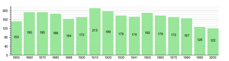
The chart below shows how the population of Châtelat has changed over many years:
Special Places: Sights
The entire village of Châtelat is recognized as an important historical site in Switzerland. It is part of the Inventory of Swiss Heritage Sites, which means it has special cultural value.
How People Make a Living: Economy

In 2011, the unemployment rate in Châtelat was very low, at 0.49%. This means almost everyone who wanted a job had one. In 2008, 61 people worked in the town.
- Primary sector: 40 people worked in farming and related businesses. This was the biggest job area.
- Secondary sector: 15 people worked in manufacturing (making things).
- Tertiary sector: 6 people worked in services, like technical jobs or education.
Most people (87.5%) who worked in Châtelat also lived there. However, more people left Châtelat to work elsewhere than came into Châtelat for work.
In 2011, a married person in Châtelat earning 150,000 CHF paid about 13% in local and canton taxes. An unmarried person paid about 19.1%.
Beliefs: Religion
In 2000, about 23.8% of the people in Châtelat belonged to the Swiss Reformed Church. About 3.3% were Roman Catholic. A large group (61.48%) belonged to other Christian churches. Some people (4.92%) did not belong to any church, and a few (6.56%) did not answer the question.
Learning and Schools: Education
In Châtelat, about 47.7% of adults had finished high school (non-mandatory upper secondary education). About 12.3% had gone on to higher education, like a university.
The school system in the Canton of Bern starts with one year of optional Kindergarten. Then, students go to six years of Primary school. After that, they have three years of lower Secondary school. In Secondary school, students are grouped by their abilities. After lower Secondary, students can continue their education or start an apprenticeship (learning a job while working).
During the 2011-12 school year, 20 students attended primary school classes in Châtelat. In 2000, 9 students went to school in Châtelat. Most of these students (7) came from other towns. Also, 14 residents of Châtelat went to schools outside of the town.
See also
 In Spanish: Ch%C3%A2telat para ni%C3%B1os
