
Cimarron, Colorado facts for kids
Quick facts for kids
Cimarron, Colorado
|
|
|---|---|

In 1883
|
|

Cimarron, Colorado
Location in Colorado

Cimarron, Colorado
Location in the United States
|
|
| Country | |
| State | |
| County | Montrose County |
| Elevation | 2,102 m (6,897 ft) |
| Time zone | UTC-7 (MST) |
| • Summer (DST) | UTC-6 (MDT) |
| ZIP Code |
81220
|
| GNIS feature ID | 188168 |
Cimarron is a small, quiet community in Montrose County, Colorado, United States. It's not officially a town, but rather an unincorporated hamlet. You can find it on the north side of U.S. Highway 50. It's about 19 miles east of Montrose and 42 miles west of Gunnison, Colorado.
Even though it's small, Cimarron has a store where you can get fuel. It also has a post office that serves the local rural area. The ZIP Code for Cimarron is 81220.
Cimarron is located right next to the Cimarron River. It's also very close to the famous Black Canyon of the Gunnison and the beautiful Curecanti National Recreation Area.
Exploring Cimarron's Landmarks
One cool historical spot near Cimarron is the D & RG Narrow Gauge Trestle. This old bridge crosses the Cimarron River gorge. It's so important that it's listed on the National Register of Historic Places. This means it's a special place worth protecting!

Understanding Cimarron's Climate
Cimarron has a climate that gets a bit of everything. It's mostly a humid continental climate. This means it has warm summers and cold, snowy winters. Sometimes, it can also feel like a cold semi-arid climate, which means it's quite dry.
The weather can change a lot between day and night. It also gets a good amount of snow, especially in winter.
Images for kids
-
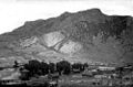
Cimarron in 1883, showing its early days.
See also
 In Spanish: Cimarrón (Colorado) para niños
