
Cimarron River (Arkansas River tributary) facts for kids
Quick facts for kids Cimarron River |
|
|---|---|

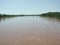
The Cimarron River, near Forgan, Oklahoma
|
|

Map of the Arkansas River basin with the Cimarron River highlighted.
|
|
| Country | United States |
| State | Colorado, Kansas, New Mexico, Oklahoma |
| Cities | Cushing, Oklahoma, Mannford, Oklahoma |
| Physical characteristics | |
| Main source | Confluence of Dry Cimarron River and Carrizozo Creek Kenton, Cimarron County, Oklahoma 4,318 ft (1,316 m) 36°54′24″N 102°59′12″W / 36.90667°N 102.98667°W |
| River mouth | Arkansas River Keystone Lake, at Westport, Pawnee County, Oklahoma 722 ft (220 m) 36°10′14″N 96°16′19″W / 36.17056°N 96.27194°W |
| Length | 698 mi (1,123 km) |
| Basin features | |
| Basin size | 18,950 sq mi (49,100 km2) |

The Cimarron River is a long river in the United States. It stretches for about 698 miles (1,123 km) (1,123 km). The river flows through four states: New Mexico, Oklahoma, Colorado, and Kansas. Its journey begins in northeastern New Mexico, near Folsom.
Most of the Cimarron River's path is in Oklahoma. It either forms the border of or flows through eleven counties there. You won't find any large cities directly along its route. The river eventually joins the Arkansas River at Keystone Reservoir in Oklahoma. This reservoir is the only place where the river's flow is held back by a dam. The Cimarron River collects water from an area of about 18,927 square miles (49,020 km2) (49,020 km2).
What's in a Name?
The name Cimarron comes from an old Spanish name. It was called Río de los Carneros Cimarrón. This means "River of the Wild Sheep." Early explorers gave it this name because of the wild animals they saw.
River's Journey and Features
In parts of New Mexico and western Oklahoma, the river is known as the Dry Cimarron River. Even though it's called "Dry," it's not always completely dry. Sometimes, its water flows hidden beneath the sand in the riverbed. A scenic road, the Dry Cimarron Scenic Byway, follows this part of the river.
The river officially becomes the Cimarron River when it meets Carrizozo Creek. This happens just inside Oklahoma, near Kenton, Oklahoma. Carrizozo Creek also starts in New Mexico and crosses the state border multiple times. As the Cimarron River continues, other smaller creeks join it. These include North Carrizo Creek, Tesesquite Creek, and South Carrizo Creek. It also meets Cold Springs Creek, Ute Canyon Creek, and Flagg Springs Creek.
The Cimarron River flows along the southern edge of Black Mesa. This is the highest point in Oklahoma. When the river first enters Kansas, it flows through the Cimarron National Grassland. This is a large area of protected grasslands.
The water quality of the Cimarron River is not very good. This is because the river flows over natural mineral deposits and salt plains. It also passes through salty springs. As it flows, the water dissolves large amounts of these minerals and salt. The river also picks up a lot of red soil. It carries this soil all the way to where it ends. Before the Keystone Dam was built, this red soil would even change the color of the Arkansas River downstream.
Images for kids
-
Cimarron River near Guthrie, Oklahoma during a flood. Photo by National Weather Service.

See also
 In Spanish: Río Cimarrón para niños
