
Forgan, Oklahoma facts for kids
Quick facts for kids
Forgan, Oklahoma
|
|
|---|---|

Location in Beaver County and state of Oklahoma.
|
|
| Country | United States |
| State | Oklahoma |
| County | Beaver |
| Area | |
| • Total | 0.39 sq mi (1.02 km2) |
| • Land | 0.39 sq mi (1.02 km2) |
| • Water | 0.00 sq mi (0.00 km2) |
| Elevation | 2,585 ft (788 m) |
| Population
(2020)
|
|
| • Total | 450 |
| • Density | 1,145.04/sq mi (441.87/km2) |
| Time zone | UTC-6 (Central (CST)) |
| • Summer (DST) | UTC-5 (CDT) |
| ZIP code |
73938
|
| Area code(s) | 580 |
| FIPS code | 40-26900 |
| GNIS feature ID | 2412637 |
Forgan is a small town located in Beaver County, Oklahoma, in the United States. In 2020, about 450 people lived there. It's a quiet place with a rich history, especially linked to farming and the land.
Contents
History of Forgan, Oklahoma
Forgan was named after James B. Forgan. He was a banker from Chicago who helped fund projects. The town's first newspaper, the Forgan Enterprise, started on June 6, 1912. At that time, Forgan had many businesses and even four doctors.
Farming and the Dust Bowl Impact
Since Forgan is in a great area for growing wheat, large buildings called grain elevators were built. These elevators stored the wheat before it was sent away.
However, the town faced a big challenge in the 1930s. This was during the Dust Bowl, a time when huge dust storms hit the area. Many people had to leave, and the town's population dropped to 428 by 1940.
Forgan's Modern Economy
Today, Forgan's economy still depends on farming. People grow wheat and milo (a type of grain). Ranching, which is raising cattle, is also important. The town also benefits from the oil and gas industry and large hog farms.
Geography of Forgan
Forgan is located between two rivers: the Cimarron River and the Beaver River. The town covers a total area of about 0.4 square miles (1.02 square kilometers). All of this area is land.
Forgan's Population Over Time
| Historical population | |||
|---|---|---|---|
| Census | Pop. | %± | |
| 1920 | 582 | — | |
| 1930 | 605 | 4.0% | |
| 1940 | 428 | −29.3% | |
| 1950 | 410 | −4.2% | |
| 1960 | 532 | 29.8% | |
| 1970 | 496 | −6.8% | |
| 1980 | 611 | 23.2% | |
| 1990 | 489 | −20.0% | |
| 2000 | 532 | 8.8% | |
| 2010 | 547 | 2.8% | |
| 2020 | 450 | −17.7% | |
| U.S. Decennial Census | |||
In 2010, there were 547 people living in Forgan. The town had about 239 homes.
Who Lives in Forgan?
Most people in Forgan are White. A smaller number of people are Native American or Asian. Some residents are from other backgrounds, and about 14% of the population is Hispanic or Latino.
Households and Families
There were 197 households in Forgan in 2010. About 37% of these homes had children under 18 living there. Many homes (57.9%) were married couples living together. Some homes (12.2%) had a female head of household without a husband.
The average household had about 2.7 people. The average family had about 3.2 people.
Age Groups in Forgan
The population of Forgan is spread out across different age groups. About 33% of the people were under 18 years old. Around 11% were 65 years or older. The average age in the town was 33 years old.
Income and Economy
In 2010, the average income for a household in Forgan was about $26,739 per year. For families, the average income was around $29,167. About 17.9% of the people in Forgan lived below the poverty line. This included about 24.4% of children under 18.
Images for kids
-
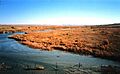
The Cimarron River, which flows near Forgan, Oklahoma.

See also
 In Spanish: Forgan (Oklahoma) para niños
