
City of Parks facts for kids
The City of Parks is a big plan to create many new parks and a long trail for walking and biking in and around Louisville, Kentucky. This exciting project was announced on February 22, 2005. The plan includes turning about 4,000 acres (about 1,600 hectares) of land near Floyds Fork into beautiful park areas. It also involves making the Jefferson Memorial Forest larger and adding more land along the riverfront for trails. There are also plans to connect Louisville's trail system to a 7-mile (11 km) trail in Southern Indiana, linking cities like New Albany, Clarksville, and Jeffersonville.
Contents
Exploring the Louisville Loop Trail
The Louisville Loop is a long trail for bikes and walkers that is being built to circle the city of Louisville, Kentucky. When finished, this trail is planned to be about 100 miles (160 km) long. It will connect many of the city's parks, both old and new, making it easy for everyone to enjoy nature and stay active.
A Look Back at the Trail's History

Louisville's first attempt at a bike path was the Beargrass Bikeway. It opened in 1980 and connected Cherokee Park to the Belvedere. Later, in 1988, people suggested extending a section from the Belvedere to Shawnee Park. These early efforts helped pave the way for the much larger Louisville Loop project.
Completed Sections of the Loop
By May 2012, about 30 miles (48 km) of the Louisville Loop were already completed. These sections stretched from the Farnsley-Moremen House all the way to Downtown Louisville.
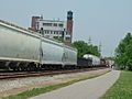
The Riverwalk was the first part of the Louisville Loop to be finished. It was built in the 1980s. This trail is about 6.9 miles (11.1 km) long and runs along the Ohio River waterfront. It goes from the Belvedere to Chickasaw Park, passing through Lannan Park and Shawnee Park. Some parts of the Riverwalk are on city streets and sidewalks. Along the trail, you can find markers every tenth of a mile. These markers also share interesting facts about river life in the 1800s, like old jobs and types of boats.
The Levee Trail is another older section of the Louisville Loop. It is about 3.6 miles (5.8 km) long. This trail follows the flood protection system from Riverside Park in Pleasure Ridge Park to the Farnsley-Moremen House and Lees Lane.

In 2007, the Mill Creek Trail was completed. This 10-mile (16 km) trail connects the Levee Trail and the Riverwalk. It ends at Lee Lane in Riverside Gardens. A small part of the Mill Creek Trail was actually built earlier, in 2002, by LG&E. The city added an extension in 2007, which included a new bridge over Mill Creek. This bridge cost $2 million to build.
Upcoming Trail Developments
The entire Louisville Loop is planned to be about 100 miles (160 km) long when it is fully connected. As of 2023, construction was underway for several new parts of the Louisville Loop. These included sections near McCrawly Lake, connecting Middletown to Beckley Creek Park, and completing parts of Algonquin Parkway. Plans were also being made for trails within the Jefferson Memorial Forest. Other routes being designed included trails along the Parkways, a section near the Water Company on River Road, and a path connecting Broad Run Park to the area around Beulah Church Road.
Images for kids
-
The RiverWalk near the vertical liftgate bridge
-
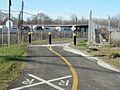
Rail crossing for the trail in Rubbertown
-
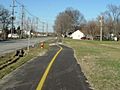
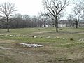
Section of the trail in West Louisville
-
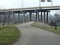
The RiverWalk going under the I-64 Causeway
-
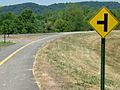
Junction of the trails leading to Mill Creek bridge and landing
-
RiverWalk at the Old Portland Wharf
-
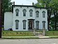
A Civil War era house off the RiverWalk
-
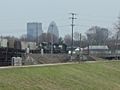
Louisville skyline viewed from the RiverWalk


See Also
