
Ciudad Hidalgo, Michoacán facts for kids
Quick facts for kids
Ciudad Hidalgo
Taximaroa
|
|
|---|---|
|
City
|
|

Aerial view of the downtown and west side of the city.
|
|

Ciudad Hidalgo
Location in Mexico
|
|
| Country | |
| State | Michoacán |
| Municipality | Hidalgo |
| Founded | 1531 (Spanish settlement) |
| Municipality Founded | 1831 |
| Area | |
| • City | 1,063.06 km2 (410.45 sq mi) |
| Elevation
(of seat)
|
2,060 m (6,760 ft) |
| Population
(2020) Municipality
|
|
| • City | 115,035 |
| • Seat | 71,528 |
| Time zone | UTC-6 (Central (US Central)) |
| • Summer (DST) | UTC-5 (Central) |
| Postal code (of seat) |
61100
|
| Website | Web site |
Ciudad Hidalgo, or simply Hidalgo, is a city in the state of Michoacán, Mexico. It is the main city of the Hidalgo Municipality. The city is in a rural, mountainous area. Even though many buildings are modern, its most important old building is the 16th-century church and former monastery of San José.
Long ago, the city was called Taximaroa. It was part of the Purépecha Empire and was very close to the Aztec Empire. This led to two Aztec attacks that failed. It was also where the Spanish first entered Purépecha lands in 1522. Today, making furniture and working with wood are important jobs for people in Ciudad Hidalgo and nearby towns. However, cutting down too many trees is a problem. So, the area is now trying to attract visitors to enjoy its beautiful nature and historical places.
Contents
About Ciudad Hidalgo


Ciudad Hidalgo is one of the ten most important cities in Michoacán. Most of its buildings and streets are modern. But it still feels a bit like a countryside town, especially in how people make a living.
The city has fun events throughout the year:
- During Holy Week, there is a fair for homemade preserved fruits and vegetables. People have been making these foods here since the early 1900s.
- The city hosts the biggest furniture show in Michoacán, called Expo Mueble.
- The Expo Feria de Todos los Santos is a fair connected to Day of the Dead and All Saints Day.
Historical Buildings
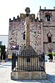
The most important old building is a 16th-century church with a former monastery. It still has its original courtyard, called an atrium. In the atrium, there is a special stone cross made by local people long ago. This cross sits on a pyramid-shaped base with a skull and bones. It also shows the symbol of the Franciscan religious group. The pyramid base and skulls show the influence of local cultures. There is even a shiny obsidian mirror on the cross. This mirror was a symbol of the god Tezcatlipoca, who was worshipped by both the Aztecs and the Purépecha people.
Inside the church, there are two interesting baptismal fonts. One large font might have been a public fountain in the 1500s. It has small angels and lion designs. There are also letters on its edge, but they don't spell words. People say they were used to teach reading. The smaller font is made from one stone and has a small angel design.
Another important church is Nuestra Señora del Perpetuo Socorro (Our Lady of Perpetual Succour). It is just outside the city center. This church was finished in 1977 and looks red because it's made of brick. It has a modern design with straight lines.
The Casa de la Cultura (Cultural Center) in the city offers many classes. Kids and adults can learn dance, flower arranging, painting, textiles, computers, music, and more.
Hidalgo Municipality

Ciudad Hidalgo is the main city for over 500 other communities in the area. Together, they form the Hidalgo Municipality, which covers about 1,063 square kilometers. More than half of the municipality's 110,311 people (from 2005) live in Ciudad Hidalgo itself.
Many towns in the municipality focus on forestry, like Agostitlán and Huajúmbaro. San Matías is known for farming and crafts. San Bartolo Cuitareo and Jose Maria Morelos focus on farming and forestry. In 2005, about 155 people in the municipality spoke an indigenous language, mostly Otomi. These Otomi people mainly live in San Matías and San Bartolo Cuitareo.
The municipality is in the far east of Michoacán, about 104 km from Morelia, the state capital. It shares borders with several other municipalities.
Nature and Geography
The city is in a flat valley surrounded by mountains. These mountains are covered with pine trees, oyamels, holm oak, and other types of trees. The weather is usually mild, with rain in the summer. The average temperature is between 8 and 20 degrees Celsius.
The municipality is part of the Trans-Mexican Volcanic Belt, which includes the Sierra de Mil Cumbres mountain range. Important peaks include Del Fraile and San Andres. Rivers like Agostitlan and Grande flow through the area, with dams like Sabaneta. You can find animals like coyotes, foxes, skunks, opossums, rabbits, raccoons, and armadillos here. Cerro San Andres is home to one of the places where monarch butterflies gather, even though it's not part of the main Biosphere Reserve.
Natural Attractions
Just outside the city, there are caves called the Grutas de Tziranda. "Tziranda" means "paper" in the Purépecha language. These caves stretch for about 300 meters and have thousands of amazing rock formations made of calcite and other minerals. About twenty types of bats live and have their babies inside these caves. The caves are lit up, and music plays for visitors.
The Los Azufres Park is famous for its hot springs, which are heated by an inactive volcano. This area is very large and high up in the mountains. People have believed the springs have healing powers since ancient times. Many spas are in the area, like Laguna Larga and Eréndira. The calm waters of Laguna Larga reflect the green trees around them. Laguna Verde is green because of the sulfur in its water. In some places, you can even see mud boiling in craters! The water in Laguna Los Azufres is very hot and full of minerals like sulfur. There are also geysers (natural hot water spouts) and fresh water springs.
The heat from this area is used to make electricity. There are hotels, spas, and other businesses that offer fun activities like camping, cycling, rowing, swimming, and hiking.
Economy
Working with wood and making wood products are very important for the economy of Ciudad Hidalgo and the municipality. However, cutting down too many trees has become a problem. The local government wants to grow tourism to use the area's natural beauty and reduce its reliance on forestry. Currently, tourism makes up only about three percent of the economy.
About thirty percent of the economy comes from industry, which includes making processed foods, metal items, furniture, and textiles. About twenty percent of the economy is based on farming and raising animals. Farmers grow corn, wheat, tomatoes, peaches, apples, and avocados. They also raise chickens, cows, pigs, and horses. The area also has minerals like lime, clay, and sulfur. Most of the rest of the economy comes from small, family-owned shops.
History of Ciudad Hidalgo
The original name of this area was Taximaroa. The meaning of this name is not fully clear. Some say it means "altar of the god's put on the road," referring to a place where the Purépecha people defeated the Aztecs. Another idea is that it means "place of carpenters," which is what the Aztec name for the place, Tlaximaloyan, means.
The first people to live here were the Otomi, who arrived thousands of years ago. They called the area "Ouesehuarape," meaning "place where they cut wood." In 1401, the Purépecha people took control of the area. This made it the closest part of their empire to the Aztec Empire.
In 1479, the Aztec leader Axayacatl attacked Taximaroa with 24,000 warriors and burned the city. But the Purépecha later drove them out, and the town was rebuilt. The Aztecs attacked again in 1495 under Moctezuma II, but they were defeated once more. After this, the Purépecha built a special center to remember their victory over the Aztecs.
In 1522, the Spanish, led by Cristóbal de Olid, arrived in Taximaroa. This was their first time entering Purépecha lands. Olid took control of the native settlement, and the first Catholic Mass in Purépecha territory was held here. Before another Spanish leader, Nuño de Guzmán, arrived in 1529, the local people decided to leave Taximaroa.
The Franciscans, a group of Catholic missionaries, came to the area in 1531 to teach the native people. They rebuilt the settlement, giving it the Spanish town layout we see today. In 1535, Hernán Cortés visited the area and gave the settlement and its lands to Gonzalo de Salazar. Cortés also had a hospital built for the native people. In 1591, Taximaroa became a self-governing "Indian Republic" and the main town for the region. Later that decade, the San José church and monastery complex began to be built.
After Mexico became independent from Spain, the area became the municipality of Taximaroa in 1831. During the Mexican Revolution, federal troops attacked the town. In 1914, a battle called the Sabaeta Action took place, where troops supporting Venustiano Carranza won. After the Revolution, the settlement became a city and changed its name to Ciudad Hidalgo. This new name honors Miguel Hidalgo y Costilla, a hero of Mexican Independence, who owned a hacienda (a large estate) near here in the late 1700s.
Population
In 2020, Ciudad Hidalgo had 71,528 people living there. This makes it the 8th most populated city in Michoacán. It is also the second most populated city in the eastern part of Michoacán, after Heroica Zitácuaro.
See also
 In Spanish: Ciudad Hidalgo (Michoacán) para niños
Images for kids
-

Aerial view of the downtown and west side of the city.
-
The San José parish church
-
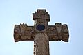
A close-up of the atrium cross, showing the obsidian mirror
-
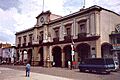
The Municipal Palace of Hidalgo
