Clare, Iowa facts for kids
Quick facts for kids
Clare, Iowa
|
|
|---|---|

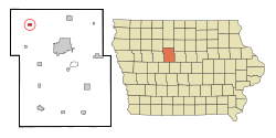
Location of Clare, Iowa
|
|
| Country | |
| State | |
| County | Webster |
| Incorporated | 1882 |
| Area | |
| • Total | 0.50 sq mi (1.28 km2) |
| • Land | 0.50 sq mi (1.28 km2) |
| • Water | 0.00 sq mi (0.00 km2) |
| Elevation | 1,155 ft (352 m) |
| Population
(2020)
|
|
| • Total | 136 |
| • Density | 274.19/sq mi (105.92/km2) |
| Time zone | UTC-6 (CST) |
| • Summer (DST) | UTC-5 (CDT) |
| ZIP code |
50524
|
| Area code(s) | 515 |
| FIPS code | 19-13485 |
| GNIS feature ID | 0455422 |
Clare is a small city located in Webster County, Iowa, in the United States. In 2020, about 136 people lived there. The city was started around 1882 by people who came from Clare County, Ireland. Clare also has its own post office on West Front Street.
Contents
Geography of Clare
Clare is found at specific coordinates: 42 degrees North and 94 degrees West. This helps us locate it on a map.
The United States Census Bureau says that Clare covers about 0.51 square miles (1.28 square kilometers). All of this area is land.
Clare is located inside the eastern part of the Manson crater. This is a very old impact structure, like a giant bowl, that is now hidden under layers of dirt and rock left by glaciers.
People of Clare
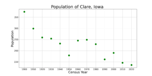
| Historical population | |||
|---|---|---|---|
| Census | Pop. | %± | |
| 1900 | 374 | — | |
| 1910 | 299 | −20.1% | |
| 1920 | 259 | −13.4% | |
| 1930 | 254 | −1.9% | |
| 1940 | 232 | −8.7% | |
| 1950 | 179 | −22.8% | |
| 1960 | 245 | 36.9% | |
| 1970 | 249 | 1.6% | |
| 1980 | 229 | −8.0% | |
| 1990 | 161 | −29.7% | |
| 2000 | 190 | 18.0% | |
| 2010 | 146 | −23.2% | |
| 2020 | 136 | −6.8% | |
| U.S. Decennial Census | |||
Clare's Population in 2020
According to the census from 2020, 136 people lived in Clare. There were 51 households and 37 families. The city had about 274 people per square mile.
Most of the people living in Clare (about 94%) were White. A small number were Native American or from two or more races. About 1.5% of the people were Hispanic or Latino.
In terms of households, about 25% had children under 18 living with them. Most households (60.8%) were married couples. About 27.5% of all households were made up of single individuals.
The average age in Clare was 37.8 years. About 25% of residents were under 20 years old. Also, about 24% were 65 years or older. There were slightly more males (55.9%) than females (44.1%) in the city.
Clare's Population in 2010
The census in 2010 showed that 146 people lived in Clare. There were 65 households and 41 families. The city had about 286 people per square mile.
Most people (97.3%) were White. A small number were African American or from other races. About 1.4% of the population was Hispanic or Latino.
Out of the 65 households, 21.5% had children under 18. About 53.8% were married couples. About 30.8% of all households were individuals living alone.
The average age in 2010 was 42.5 years. About 19.2% of residents were under 18. Also, 18.5% were 65 years or older. The city had slightly more males (53.4%) than females (46.6%).
Education in Clare
The Manson–Northwest Webster Community School District serves the community of Clare. This school district was created on July 1, 1993. It was formed when the Manson and Northwest Webster school districts joined together.
See also
 In Spanish: Clare (Iowa) para niños


