Clarksburg, Missouri facts for kids
Quick facts for kids
Clarksburg, Missouri
|
|
|---|---|

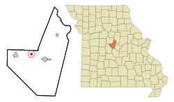
Location in Moniteau County and the state of Missouri
|
|
| Country | United States |
| State | Missouri |
| County | Moniteau |
| Founded | 1884 |
| Named for | Postmaster Hiram Clark |
| Area | |
| • Total | 0.58 sq mi (1.50 km2) |
| • Land | 0.58 sq mi (1.49 km2) |
| • Water | 0.00 sq mi (0.01 km2) |
| Elevation | 906 ft (276 m) |
| Population
(2020)
|
|
| • Total | 254 |
| • Density | 440.21/sq mi (169.95/km2) |
| Time zone | UTC-6 (Central (CST)) |
| • Summer (DST) | UTC-5 (CDT) |
| ZIP code |
65025
|
| Area code(s) | 573 |
| FIPS code | 29-14140 |
| GNIS feature ID | 2393540 |
Clarksburg is a small city located in Moniteau County, Missouri, in the United States. In 2020, about 254 people lived there. This was a bit less than the 334 people counted in 2010. Clarksburg is part of the larger Jefferson City metropolitan area.
Contents
History of Clarksburg
Clarksburg got its name from an early postmaster (the person in charge of a post office) named Hiram Clark. A post office first opened in the area in 1884.
Geography of Clarksburg
Clarksburg is located in the western part of Moniteau County. It is about 6 miles (10 km) west-northwest of California, which is the main town and county seat of Moniteau County. It's also about 7 miles (11 km) east-northeast of Tipton. You can reach Clarksburg by driving about 1 mile (1.6 km) north from U.S. Route 50 on Highway H.
The city covers a total area of about 0.58 square miles (1.50 km2). Most of this area is land, with only a tiny part, about 0.52%, being water. Clarksburg is built on high ground. Water from the city flows north towards West Brush Creek, which then goes to Moniteau Creek and eventually the Missouri River. Water also flows south towards North Moreau Creek, which leads to the Moreau River and then also to the Missouri River.
People of Clarksburg (Demographics)
| Historical population | |||
|---|---|---|---|
| Census | Pop. | %± | |
| 1900 | 509 | — | |
| 1910 | 399 | −21.6% | |
| 1920 | 441 | 10.5% | |
| 1930 | 394 | −10.7% | |
| 1940 | 393 | −0.3% | |
| 1950 | 366 | −6.9% | |
| 1960 | 357 | −2.5% | |
| 1970 | 343 | −3.9% | |
| 1980 | 352 | 2.6% | |
| 1990 | 358 | 1.7% | |
| 2000 | 375 | 4.7% | |
| 2010 | 334 | −10.9% | |
| 2020 | 254 | −24.0% | |
| U.S. Decennial Census | |||
Clarksburg in 2010
In 2010, the city of Clarksburg had 334 people living in 115 households. Most of the people (about 97.9%) were White. A small number were Native American or from other backgrounds. About 1.8% of the population identified as Hispanic or Latino.
Many households (48.7%) had children under 18 living with them. The average household had about 2.9 people. The average age of people in Clarksburg was 31.7 years old. About 34.1% of residents were under 18, and 7.8% were 65 or older. The population was almost evenly split between males (49.1%) and females (50.9%).
See also

- In Spanish: Clarksburg (Misuri) para niños
 | Aurelia Browder |
 | Nannie Helen Burroughs |
 | Michelle Alexander |

