Cleone, California facts for kids
Quick facts for kids
Cleone
|
|
|---|---|

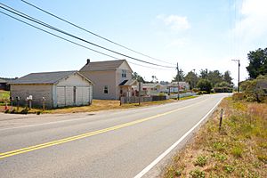
Along State Highway 1 in Cleone
|
|

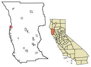
Location in Mendocino County and California
|
|
| Country | |
| State | |
| County | Mendocino |
| Area | |
| • Total | 1.62 sq mi (4.2 km2) |
| • Land | 1.59 sq mi (4.1 km2) |
| • Water | 0.02 sq mi (0.05 km2) 1.50% |
| Elevation | 79 ft (24 m) |
| Population
(2020)
|
|
| • Total | 622 |
| • Density | 390.46/sq mi (150.76/km2) |
| Time zone | UTC-8 (Pacific (PST)) |
| • Summer (DST) | UTC-7 (PDT) |
| ZIP Code |
95437 (Fort Bragg)
|
| Area code(s) | 707 |
| GNIS feature IDs | 1655905; 2628718 |
Cleone (which used to be called Kanuck) is a small community in Mendocino County, California, United States. It's a special type of place called a census-designated place, which means it's a community that the government counts for population but isn't officially a city.
Cleone is located about 3.25 miles (5.2 km) north of Fort Bragg right on California State Highway 1. It sits at an elevation of 79 feet (24 m) above sea level. The name Cleone probably comes from "Kelio," which was a village or group of the Pomo people, who are Native Americans. In 2020, about 622 people lived there.
History of Cleone
The area had a post office called Kanuck that opened in 1883. It quickly changed its name to Cleone in the same year, but then closed in 1908.
In 1883, a sawmill was built about 1.5 miles (2.4 km) east of Cleone. This mill made wood products. The wood was then sent from a wharf (a kind of dock) in Cleone. Special railroad cars would roll down a hill by gravity to the shipping area. Horses would then pull the empty cars back up the hill.
Geography
Cleone covers an area of about 1.6 square miles (4.1 km2). Most of this area is land, with only a small part, about 0.02 square miles (0.05 km2), being water. This means about 1.50% of Cleone's total area is water.
People of Cleone
| Historical population | |||
|---|---|---|---|
| Census | Pop. | %± | |
| 2010 | 618 | — | |
| 2020 | 622 | 0.6% | |
| U.S. Decennial Census | |||
According to the 2010 United States Census, Cleone had 618 people living there. The population density was about 382.1 inhabitants per square mile (147.5/km2) (meaning how many people live in each square mile).
Most of the people in Cleone were White (83.8%). There were also people from other races, including African American, Native American, and Asian residents. About 20.1% of the people were Hispanic or Latino.
All 618 people lived in homes. There were 285 households in total. About 23.2% of these households had children under 18 living in them. The average household had about 2.17 people.
The population included people of all ages. About 17.3% were under 18 years old, and 21.2% were 65 years or older. The average age in Cleone was about 49.6 years.
Education
Cleone is part of the Fort Bragg Unified School District. Students in Cleone attend Fort Bragg High School for their high school education.
Nearby Attractions
The main entrance to MacKerricher State Park is located right in Cleone. This state park is a popular place for outdoor activities and enjoying nature.
See also
 In Spanish: Cleone (California) para niños
 | Madam C. J. Walker |
 | Janet Emerson Bashen |
 | Annie Turnbo Malone |
 | Maggie L. Walker |


